River Irvine

The River Irvine is a river of Ayrshire, 29½ miles long, which divides Cunninghame, the county's northern portion, from Kyle.
The source of the river is on the Lanarkshire border, at an altitude of 810 feet above sea-level, near Loudoun Hill, seven miles west of Strathaven. The river flows westward, and reaches the sea in a joint estuary with the River Garnock, entering Irvine Harbour and Irvine Bay on the Firth of Clyde.
The river on its long course takes in many tributaries, some of which form parish boundaries.
The course of the Irvine and its tributaries
The River Irvine rises in two head-waters, the one in a moss at Meadow-head, on the eastern boundary of the parish of Loudoun, and that of Ayrshire, and the other a mile eastward in the parish of Avondale in Lanarkshire, near the battle-field of Drumclog.

About 2¾ miles from the point of its entering Ayrshire, it is joined from the north by Glen Water, which strictly speaking is the parent stream, on account of its length and the volume of water it carries; for the Glen Water rises at Crosshill in Renfrewshire, and runs six miles southward, joined by five rills in its progress, to the point of confluence with the Irvine. Swollen by this substantial tributary, the Irvine immediately passes the town of Darvel on the right — 1¾ mile onward, the town of Newmilns — at 2¼ miles farther on, the town of Galston, on the left. The Hagg burn joins before the town, having run past the old ruined castle of Arclowden: Old Loudoun Castle or "The Old Place", near the present Loudoun castle.[1] The Burnanne joins at Galston.
A mile and a quarter below Galston the river receives from the north the Polbaith Burn; ¾ of a mile lower down, it is joined from the south by the Cessnock water; and three miles later it passes Kilmarnock and Riccarton on opposite sides, and receives on its right bank the tributary of the Kilmarnock (or Marnock) Water.
Four miles downstream, it is joined on the same bank by Carmel Water; and 2½ miles farther on, it receives still on the same bank, the Annick Water's contribution. The river now runs 1½ mile in a north-westerly direction, passing through the town of Irvine; it then suddenly bends round until it follows a southerly direction; and opposite the town of Irvine, when running southward, it suddenly expands into a basin ¾ of a mile broad, which receives the Garnock river at its north-west extremity, and communicates by a narrow mouth or strait with the Firth (previously Frith)[2] of Clyde. The course of the Irvine is recorded as having shifted in an old Eglinton Estates document, a map recording the previous course with a note that the water left the old riverbed in 1758. This altered the confluence of the River Irvine with the Annick Water.[3]
The Irvine is tidal as far as the nature reserve at Shewalton, half-a-mile or so upstream from the confluence with the Annick Water.
The main contributing rivers and rivulets in descending order of their confluences are therefore the Glen Water, Polbaith Burn, Cessnock Water, Kilmarnock Water, Carmel Water, Annick Water, and the Garnock.
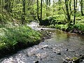
Pictures
-
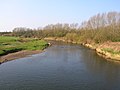
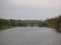 The river Irvine and the view of the viaduct from near Laigh Milton Mill
 -
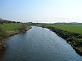
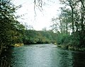
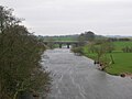 Looking up river from Laigh Milton viaduct
 -
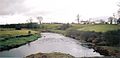
 Old Rome from Gatehead's bridge over the Irvine
 -
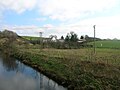
 Near the old Shewalton house and estate, Drybridge
 -
 Near the old Shewalton house and estate, Drybridge
 -
 Girtrig mill weir at Drybridge
 -
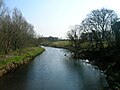
 Near the site of Maid Morville's mound at Holmford, Dreghorn
 -
 Near the site of Maid Morville's mound at Holmford, Dreghorn
 -
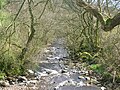
 The river at Newmilns
 -
 The river at Newmilns
 -
 The river from the Muckle Brig in Galston
 -
 The Irvine Harbour and town


Changing course
St Winnan of Kilwinning[4] is said to have made the River Garnock change its course and follow another "adverse to nature". The river's mistake was to fail to deliver up any fish to one of the saint's angler friends!
The Garnock, Annick and Irvine did not even have the same confluence within recorded history, for Timothy Pont's (1604–08) and Herman Moll's (1745) maps show the Garnock emptying into the sea, about two miles (from the mouth of the Irvine.[5] The Annick did not flow into the Garnock at this time and the Ardeer peninsula was an island. Subsequent to Pont's time, the sea came right up to the town, with vessels loading and unloading at the Seagate, which is now half-a-mile from the sea.
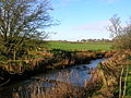
Tributaries of the Irvine
-
 The Annick Water, upstream from Chapeltoun Bridge
 -
 The path near Anderson's Plantation
 -
 The Annick Water from Bourtreehill.
 -
 A view of the Brackenburn at Little Alton
 -
 The Burnanne near its confluence with the Irvine
 -
 A view of the Burnanne at Bank Wood Bridge.
 -
 Near the site of St Anne's Holy Well.
 -
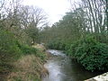
 The Carlin Burn at Hareshawmuir Water
 -
 The Carlin Stone beside the Carlin Burn.
 -
 The Carmel Water in Kilmaurs
 -
 The Chapel Burn near its confluence with the Annick Water.
 -
 The Clerkland Burn at Clerkland West farm
 -
 The Clerkland Burn at Clerkland House
 -
 The Cowlinn Burn from Clonbeith
 -
 The old Glazert ford at Haysmuir
 -
 The Glazert Rivulet and the Annick Water at Water Meetings
 -
 The Glazert at Gallowayford.
 -
 The River Garnock downstream from Dalgarven Mill.
 -
 A view of the Glen Water at Law Bridge in Darvel.
 -
 The Hag Burn at Jocklan Bridge
 -
 The Hareshawmuir Water
 -
 The Lugton Water at Lugton
 -
 The Lugton Water at Caven Bridge, Montgreenan
 -
 The Templeton Burn in the Armsheugh Plantation near Crookedholm


Taming the river
Flood prevention schemes have canalised the Kilmarnock (previously the Marnock) Water where it runs down through Kilmarnock towards the Irvine, with significantly raised banks and automatically closing gates. The Irvine has likewise been tamed with a large flood prevention scheme at east Holmes Wetlands near Galston. Here the river is directed into its old floodplains when the water rises above a certain height, thereby protecting Kilamarnock. A scheme on the River Cessnock is underway (2007). Many sections of the other rivers have been canalised and / or have bunds on either bank to prevent the watercourses flooding into their flood plains.

Wildlife
The river and its banks, support, amongst others, kingfishers, tawny and barn owls, herons, moorhean, coot, mallard, ravens, rooks, treecreepers, buzzards, peewits or lapwings, roe deer, mink, moles, shrews, grey squirrels, hares, hedgehogs, foxes, badgers, pipistrelle bats and otters. Migrating Canada and Graylag Geese frequent the nearby fields on their way up from the Solway Firth and the Caerlaverock area or coming down from Svalbard in the winter.
The river's water quality is generally quite good nowadays, proven by the presence of freshwater limpets and shrimps, together with leeches, caddis fly larvae and water snail species. Pont in 1604 – 08 writes that salmon are plentiful in the River Irvine. The river system contains, amongst others, brown trout, sea trout, salmon, eels, minnows, lampreys, and sticklebacks. Freshwater mussels, a species persecuted for its pearls, are found in places on the Glazert and the Garnock.

Outside links
| ("Wikimedia Commons" has material about River Irvine) |
- Location map: 55°36’0"N, 4°42’0"W
- Video and commentary at Water Meetings confluence of the Annick & Glazert Waters
References
- ↑ Robertson, William (1908). Ayrshire. Its History and Historic Families. Vol. 1. Pub. Dunlop & Dreenan. Kilamrnock. P. 155
- ↑ MacIntosh, John (1894). Ayrshire Nights Entertainments: A Descriptive Guide to the History, Traditions, Antiquities, etc. of the County of Ayr. Pub. Kilmarnock. P. 11.
- ↑ National Archives of Scotland. RHP3/37.
- ↑ Robertson, William (1908). Ayrshire. Its History and Historic Families. Vol. 1. Pub. Dunlop & Dreenan. Kilmarnock. P. 33.
- ↑ Paterson, James (1863–66). History of the Counties of Ayr and Wigton. V. – III – Cunninghame. J. Stillie. Edinburgh. P. 257.