Keadby
| Keadby | |
| Lincolnshire | |
|---|---|
 Keadby Bridge | |
| Location | |
| Grid reference: | SE8311 |
| Location: | 53°35’49"N, -0°44’30"W |
| Data | |
| Population: | 1,930 (2011) |
| Post town: | Scunthorpe |
| Postcode: | DN15 |
| Dialling code: | 01724 |
| Local Government | |
| Council: | North Lincolnshire |
| Parliamentary constituency: |
Scunthorpe |
Keadby is a small village in Lindsey, Lincolnshire. It is situated just off the A18 road, west of Scunthorpe, and on the west bank of the River Trent. The civil parish is called Keadby with Althorpe with a population at the 2011 census of 1,930.[1]
Community
Keadby is pronounced "Kidby".
Keadby's three public houses are now closed: The Barge (previously the Friendly Fox, earlier the Friendship); The Auld South Yorkshire, fire-damaged in 2011 although there are plans to rebuild; and the Mariners Arms, closed in 1991 and subsequently used as a private school.
Village amenities are a fish and chip shop, a working men's club, a small post office and a local shop.
Keadby's economic significance lies in that it was chosen as the destination for the Stainforth and Keadby Canal, opened in 1802. The canal is now mostly a leisure waterway for pleasure boaters, with Keadby being at the "end of the line". There is a lock between the canal and the tidal River Trent. At Keadby is Keadby Power Station, and 'Port Services', a small port for inward-bound timber and scrap metal.
On occasion the village is prone to flooding. In May 2006, due to heavy rainfall, ground floors of several houses were flooded in the Queens Crescent and Day Close areas.
King George V Bridge

- Main article: Keadby Bridge
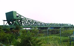
The nearest settlement is Keadby (although the railway station by the bridge is called Althorpe, a village farther away), where the King George V Bridge (also known as Keadby Lifting Bridge) provides a crossing for twin rail lines, a road and a pedestrian walkway over the Trent, connecting the Isle of Axholme to Scunthorpe and the rest of Lincolnshire. The bridge opened on 21 May 1916, at which time the 3,000-ton lifting span was Europe's heaviest bascule bridge.[2] The lifting span was fixed in position in 1955 and no longer opens.
Moveable bridges

The King George V Bridge is not the only moveable bridge in the vicinity of Keadby. There are canal locks at the point where the Stainforth and Keadby Canal connects with the River Trent in Keadby. On the canal, just before these locks, the B1392 road crosses the canal over the Keadby Swing Bridge. Approximately half a mile farther along the canal, a railway line crosses the canal over the Keadby Sliding Bridge, also known as Vazon Sliding Railway Bridge. This is an unusual retractable bridge that can be rolled out of the line of the canal to allow boats through. Just beyond the Sliding Bridge is a small manually operated swing bridge.[3]
References
- ↑ "Civil Parish population 2011". Neighbourhood Statistics. Office for National Statistics. http://www.neighbourhood.statistics.gov.uk/dissemination/LeadKeyFigures.do?a=7&b=11125069&c=Keadby+with+Althorpe&d=16&e=62&g=6382115&i=1001x1003x1032x1004&m=0&r=1&s=1460992105481&enc=1. Retrieved 18 April 2016.
- ↑ "Keadby Lifting Bridge". The Railway Magazine: 434. July 1953.
- ↑ "Vazon Sliding Railway Bridge". Pennine Waterways. http://www.penninewaterways.co.uk/sheffield/sy9.htm.
Outside links
| ("Wikimedia Commons" has material about Keadby) |
- Isle of Axholme website
- Friends of Althorpe and Keadby Primary School
- Pathe newsreel of flooding (unknown date) & bridge
- Pathe newsreel of the King George V bridge being lifted
| Isle of Axholme |
|---|
|
Althorpe • Amcotts • Beltoft • Crowle • Ealand • Eastoft • Epworth • Garthorpe • Haxey • Keadby • Luddington • Owston Ferry • Sandtoft • West Butterwick • Westwoodside • Wroot |