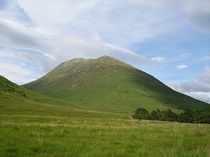
Gulvain
| Gulvain | |||
| Inverness-shire, Argyllshire | |||
|---|---|---|---|
 Gulvain from Gleann Fionnlighe | |||
| Range: | Morar | ||
| Summit: | 3,238 feet NN002875 56°56’8"N, 5°17’8"W | ||
Gulvain is a mountain on the ridge forming the border between Inverness-shire and Argyllshire. It stands to the north of the A830 road west of Fort William and south of Loch Arkaig, rising at the end of Gleann Fionnlighe. It is a Munro, reaching a height of 3,238 feet at its summit. A remote mountain, it is seven miles north of Glenfinnan and most climbs begin from the road.
The summit of Gulvain marks the northernmost point of mainland Argyllshire, albeit that the island of Canna lies further north.
Shape of the mountain
Gulvain is known in Gaelic as Gaor Bheinn, whence comes its English name, and has also been named "Culvain". It is composed of banded granite. It is shaped like a letter Y, as a corrie, Coire Sgreamhach, cuts into the northern end of the summit ridge splitting it into two. Two tops are connected by a ridge running from north-east to south-west, the northern top 10 feet higher than the one to the south. Crags drop at either end, and steep slopes fall away to either side.
The south ridge path is really a stream bed, so in wet conditions an easier, if longer, ascent from Na Socachan is to walk up Allt a Choire Reidh towards Gualann nan Osna and climb the south top's north-west ridge. The main summit ridge runs south-west to north-east with two peaks: the true summit sits at the north-eastern end of the ridge overlooking the corrie.
Ascent and summit
Most climbers will start from the Fort William road (the A830), at the west end of loch Eil, which makes for a long, steep climb pull up to the south top. Indeed, the slopes up to both west and east sides of the summit ridge are steep, especially towards the midpoint of the two peaks.
There are other long routes in from the north, from Knoydart, though it makes more of a walk, or for the hardy a cycle by mountain bike.
From the summit there are superb views to be had as Gulvain is the highest Munro in the area. The Nevis Range and Mamores appear to the south and the Knoydart hills to the north.
Outside links
| ("Wikimedia Commons" has material about Gulvain) |
- The Munros, Scottish Mountaineering Trust, 1986, Donald Bennett (Editor) ISBN 0-907521-13-4
- In the Hills of Breadalbane, V.A. Firsoff, no ISBN
- The Munros, Scotland's Highest Mountains, Cameron McNeish, ISBN 1-84204-082-0
- The Magic Of The Munros, Irvine Butterfield, ISBN 0-7153-2168-4
- Hamish's Mountain Walk, Hamish Brown, ISBN 1-898573-08-5
- Gulvain from MunroMagic
| Munros in SMC Area SMC Section 10 - Loch Eil to Glen Shiel |
|---|
|
Aonach air Chrith • Beinn Sgritheall • Creag a' Mhaim • Creag nan Damh • Druim Shionnach • Gairich • Garbh Chioch Mhor • Gleouraich • Gulvain • Ladhar Bheinn • Luinne Bheinn • Maol Chinn-dearg • Meall Buidhe • Meall na Teanga • Sgùrr a' Mhaoraich • Sgùrr an Doire Leathain • Sgùrr an Lochain • Sgùrr Mòr • Sgùrr na Cìche • Sgùrr na Sgine • Sgurr nan Coireachan (Glen Dessary) • Sgurr nan Coireachan (Glenfinnan) • Sgùrr Thuilm • Spidean Mialach • Sron a' Choire Ghairbh • The Saddle |
