Difference between revisions of "River Enborne"
(Created page with "The River Enborne at Shalford Bridge The '''River Enborne''' is a river of Berkshire and which for a whil...") |
|||
| (One intermediate revision by the same user not shown) | |||
| Line 1: | Line 1: | ||
[[File:River Enborne from Shalford Bridge.jpg|right|thumb|300px|The River Enborne at Shalford Bridge]] | [[File:River Enborne from Shalford Bridge.jpg|right|thumb|300px|The River Enborne at Shalford Bridge]] | ||
| − | The '''River Enborne''' | + | {{county|Berkshire}} |
| + | The '''River Enborne''' forms much of the border of [[Berkshire]] to the north with [[Hampshire]] to the south. | ||
| − | The | + | The river rises near the villages of [[Inkpen]] and [[West Woodhay]] in Berkshire ({{wmap|51.3704|-1.4588}}), close to the meeting of [[Berkshire]], [[Hampshire]] and [[Wiltshire]], and flows steadily eastward until it makes a sudden north-eastward turn, and ultimately it loses its waters in the [[River Kennet]] at [[Aldermaston Wharf]], in [[Berkshire]] ({{wmap|51.3914|-1.1528}}). The river is formed by a series of little brooks rising from wells on the chalk hills either side of the Berkshire and Hampshire border. |
| + | |||
| + | The river shares a name with a parish on its course, [[Enborne]], albeit that village is away from the river: only its hamlet, [[Enborne Row]] in on the riverbank. The river may be named from the village, and the village form another bourn. | ||
==Geography== | ==Geography== | ||
| Line 9: | Line 12: | ||
Eastwards, the river is crossed by the A34 (Newbury bypass) at [[Enborne Row]]. Near here, to the south, are two woodlands managed by the [[National Trust for Places of Historic Interest or Natural Beauty|National Trust]]: "The Chase" and "Great Pen Wood". | Eastwards, the river is crossed by the A34 (Newbury bypass) at [[Enborne Row]]. Near here, to the south, are two woodlands managed by the [[National Trust for Places of Historic Interest or Natural Beauty|National Trust]]: "The Chase" and "Great Pen Wood". | ||
| − | Further downstream the river passes to the south of [[Greenham Common]], and here, near [[Headley, | + | Further downstream the river passes to the south of [[Greenham Common]], and here, near [[Headley, North Hampshire|Headley]], the river is joined by a tributary from the South, from [[Ecchinswell]] and [[Watership Down|Watership Down Hill]]. |
| − | The river leaves off marking the county border at Hyde End near [[Crookham]], and from here the Enborne turns northwards into the body of Berkshire. Past [[Brimpton]] it enters the meadows around the [[River Kennet]] and meanders through these eastwards across open farmland and Brimpton Common, to join the main stream of the [[River Kennet]] near [[Aldermaston Wharf]]. | + | The river leaves off marking the county border at Hyde End near [[Crookham, Berkshire|Crookham]], and from here the Enborne turns northwards into the body of Berkshire. Past [[Brimpton]] it enters the meadows around the [[River Kennet]] and meanders through these eastwards across open farmland and Brimpton Common, to join the main stream of the [[River Kennet]] near [[Aldermaston Wharf]]. |
==The river in fiction== | ==The river in fiction== | ||
The river plays a significant part in Richard Adams' novel, ''Watership Down''. Early in the book, the rabbits from Sandleford are threatened by a dog. Blackberry realises that they can float across on a wooden board, and thus they make their escape.<ref>[http://books.google.co.uk/books?id=ittzoegmRpAC&pg=PA30 Watership Down]</ref> | The river plays a significant part in Richard Adams' novel, ''Watership Down''. Early in the book, the rabbits from Sandleford are threatened by a dog. Blackberry realises that they can float across on a wooden board, and thus they make their escape.<ref>[http://books.google.co.uk/books?id=ittzoegmRpAC&pg=PA30 Watership Down]</ref> | ||
| − | == | + | ==Pictures== |
| + | {{commons}} | ||
<gallery> | <gallery> | ||
File:Watership Down River Enborne.jpg|River Enborne | File:Watership Down River Enborne.jpg|River Enborne | ||
| − | File:Headley ford looking south - geograph.org.uk - 82101.jpg|River Enborne at Headley Ford, near | + | File:Headley ford looking south - geograph.org.uk - 82101.jpg|River Enborne at Headley Ford, near Crookham Common |
| − | File:Shalford Bridge, Near Woolhampton - geograph.org.uk - 1418.jpg|River Enborne at Shalford bridge, near | + | File:Shalford Bridge, Near Woolhampton - geograph.org.uk - 1418.jpg|River Enborne at Shalford bridge, near Brimpton |
File:Oxford Bridge near Inwood Copse - geograph.org.uk - 4839.jpg|Oxford Bridge over a small tributary of the River Enborne, near Inwood Copse | File:Oxford Bridge near Inwood Copse - geograph.org.uk - 4839.jpg|Oxford Bridge over a small tributary of the River Enborne, near Inwood Copse | ||
</gallery> | </gallery> | ||
| Line 27: | Line 31: | ||
{{reflist}} | {{reflist}} | ||
| − | + | [[Category:Rivers of Berkshire|Enborne]] | |
| − | [[Category:Rivers of | + | [[Category:Rivers of Hampshire|Enborne]] |
Latest revision as of 19:37, 2 September 2022

The River Enborne forms much of the border of Berkshire to the north with Hampshire to the south.
The river rises near the villages of Inkpen and West Woodhay in Berkshire (51°22’13"N, 1°27’32"W), close to the meeting of Berkshire, Hampshire and Wiltshire, and flows steadily eastward until it makes a sudden north-eastward turn, and ultimately it loses its waters in the River Kennet at Aldermaston Wharf, in Berkshire (51°23’29"N, 1°9’10"W). The river is formed by a series of little brooks rising from wells on the chalk hills either side of the Berkshire and Hampshire border.
The river shares a name with a parish on its course, Enborne, albeit that village is away from the river: only its hamlet, Enborne Row in on the riverbank. The river may be named from the village, and the village form another bourn.
Geography
From its source near the villages of Inkpen and Woodhay, the Enborne flows eastwards. At Smith's Bridge, near Holtwood the river begins to form the boundary between Berkshire and Hampshire, which duty it performs for most of its course, swelling as it goes.
Eastwards, the river is crossed by the A34 (Newbury bypass) at Enborne Row. Near here, to the south, are two woodlands managed by the National Trust: "The Chase" and "Great Pen Wood".
Further downstream the river passes to the south of Greenham Common, and here, near Headley, the river is joined by a tributary from the South, from Ecchinswell and Watership Down Hill.
The river leaves off marking the county border at Hyde End near Crookham, and from here the Enborne turns northwards into the body of Berkshire. Past Brimpton it enters the meadows around the River Kennet and meanders through these eastwards across open farmland and Brimpton Common, to join the main stream of the River Kennet near Aldermaston Wharf.
The river in fiction
The river plays a significant part in Richard Adams' novel, Watership Down. Early in the book, the rabbits from Sandleford are threatened by a dog. Blackberry realises that they can float across on a wooden board, and thus they make their escape.[1]
Pictures
| ("Wikimedia Commons" has material about River Enborne) |
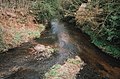
River Enborne
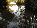
River Enborne at Headley Ford, near Crookham Common
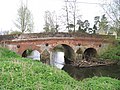
River Enborne at Shalford bridge, near Brimpton
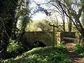
Oxford Bridge over a small tributary of the River Enborne, near Inwood Copse


