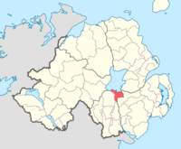
Oneilland East
Oneilland East is a barony of County Armagh, in the very northeast of the county, between the south shore of Lough Neagh and the River Blackwater, which is the boundary of County Down. It is also called Clanbrasil, from the Gaelic clan of former days, the Clann Bhreasail.[1]
The barony is part of the larger area of Armagh known as Oneilland, which was a barony before being divided into eastern and western parts. Oneilland East is bordered by three other baronies: Oneilland West to the west in Armagh; and Iveagh Lower to the east and Orior Lower to the south, both in County Down.[2]
History
Oneilland East and Oneilland West used to form the barony and Plantation precinct of Oneilland, named from its dominance by the O'Neil clan before the Plantation of Ulster. When Oneilland was split in two, Oneilland East consisted of the barony east of the River Bann, corresponding to the ancient Gaelic district of Clanbrassil.
Carrickblacker House is in Oneilland East, and is the home of the Blacker family.[3] The Blacker family are claimed as being descended from the Viking Blacar Goðfriþsson, who was a King of Dublin.[3] On 26 February 943, Blacar defeated Muirchertach mac Néill and his army, near Armagh, allegedly by the River Bann where Carrickblacker now stands.[3]
Towns and villages
The towns and villages of Oneilland East include:
Towns
Villages
Civil parishes
The civil parishes in Oneilland East are:[4][5]
- Magheralin (split with barony of Iveagh Lower, Lower Half)
- Montiaghs
- Seagoe
- Shankill (split with barony of Iveagh Lower, Lower Half)
References
- ↑ PlaceNames NI: Oneilland East
- ↑ PRONI Baronies of Northern Ireland
- ↑ 3.0 3.1 3.2 "The Blackers of Carrickblacker". Carrick Blacker. Alan Blacker. http://www.alanblacker.com/introduction.htm. Retrieved 8 June 2011.
- ↑ PRONI Civil Parishes of County Armagh
- ↑ Baronies and civil parishes of County Armagh
