Northumberland National Park


The Northumberland National Park lies wholly within Northumberland; a national park covers an area of more than 400 square miles of wild fell country from just south of Hadrian's Wall to the northernmost confines of Northumberland. It is one of the least populated and least visited of the National Parks.
The park takes up almost precisely one-fifth of the county's 2,018 square miles, covering the north and east, amongst the Pennine Fells and the Cheviots.
Contents
Landscape

The park covers several distinct areas. In the north are the Cheviots, a range of hills that joins the Pennines to the Southern Uplands. Further south, the hills give way to areas of rolling moorland, some of which have been covered by forestry plantations to form Kielder Forest on the north-western bounds of the county. The southernmost part of the park covers the dramatic central section of Hadrian's Wall.
The 10,000-year history of the region is explored through the many archaeological sites, ranging from prehistoric monuments and Roman remains to Pele towers, constructed as a defence against Border Reivers.
The official symbol adopted by the Northumberland National Park Authority is the curlew.


Geography
The national park encompasses much of the Cheviot Hills and adjoins the Southern Uplands, of which the Cheviots may be considered a part.
Kielder Forest lies within much of the park and in other areas forms a forest park. Kielder Forest is the largest man-made forest in Europe and surrounds Kielder Water.
Otterburn Training Area
The Ministry of Defence owns much of the land in the national park as the Otterburn Training Area. Some areas of this training area are off-limits, but others can be accessed only at certain times or with permission.
The training area accounts for 23% of the Northumberland National Park.
Dark Sky Park status
In December 2013 the International Dark-Sky Association conferred 'Dark Sky Park' status on the area, becoming the largest protected Dark Sky Park in Europe.[1]
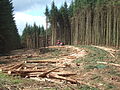
In the South of the Park, timber-harvesting is a large part of Kielder Forest's main purpose
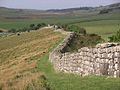
Hadrian's Wall represents a part of the National Park's historical importance
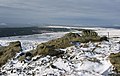
Sighty Cragg


Outside links
| ("Wikimedia Commons" has material about Northumberland National Park) |
- Location map: 55°19’1"N, 2°13’1"W
- Homepage for Northumberland National Park Authority
- Homepage for Northumberland National Park Mountain Rescue Team
References
- ↑ "Dark sky status awarded to Northumberland Park area". bbc.co.uk. 2013-12-09. http://www.bbc.co.uk/news/uk-england-tyne-25260186. Retrieved 2013-12-09.
| National Parks of the United Kingdom |
|---|
|
Brecon Beacons • Cairngorms • Dartmoor • Exmoor • Lake District • Loch Lomond and the Trossachs • New Forest • North York Moors • Northumberland • Peak District • Pembrokeshire Coast • Snowdonia • South Downs • Yorkshire Dales |