Difference between revisions of "Mutford and Lothingland"
(Created page with "{{county|Suffolk}} Mutford and Lothingland Hundred shown within Suffolk '''Mutford and Lothingland''' is a [...") |
|||
| Line 18: | Line 18: | ||
*[[Fritton]] | *[[Fritton]] | ||
*[[Gisleham]] | *[[Gisleham]] | ||
| − | *[[Gorleston-on-Sea|Gorleston]] (including South Town) | + | *[[Gorleston-on-Sea|Gorleston]] (including South Town)<sup>*</sup> |
| + | *[[Great Yarmouth]] (Cobham Island)<sup>†</sup> | ||
*[[Gunton]] | *[[Gunton]] | ||
*[[Herringfleet]] | *[[Herringfleet]] | ||
| Line 32: | Line 33: | ||
*[[Somerleyton]] | *[[Somerleyton]] | ||
{{div col end}} | {{div col end}} | ||
| + | <sup>*</sup>: Extends into Norfolk.<br /> | ||
| + | <sup>†</sup>: Mostly in Norfolk. | ||
{{Suffolk hundreds}} | {{Suffolk hundreds}} | ||
Revision as of 11:23, 23 July 2020
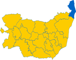
Mutford and Lothingland is a hundred in Suffolk, situated in the very north-east of the county, adjacent to the border with Norfolk. It is bounded by Wangford to the south-west; by Blything to the south; and by Norfolk to the north and west. Containing those parts of Great Yarmouth in Suffolk, it had a population of 128,624 in 2011.
Mutford is that part of the hundred south of the Oulton Broad, with Lothingland to the north. Both are shown as separate hundreds on the 1832 Boundary Commission map, although they were combined in every previous census.
It contains the following ancient parishes:
- Ashby
- Barnby
- Belton
- Blundeston
- Bradwell
- Burgh Castle
- Carlton Colville
- Corton
- Flixton
- Fritton
- Gisleham
- Gorleston (including South Town)*
- Great Yarmouth (Cobham Island)†
- Gunton
- Herringfleet
- Hopton
- Kessingland
- Kirkley
- Lound
- Lowestoft
- Mutford
- Oulton
- Pakefield
- Rushmere
- Somerleyton
*: Extends into Norfolk.
†: Mostly in Norfolk.
| Hundreds of Suffolk |
|---|
|
Babergh • Blackbourn • Blything • Bosmere and Claydon • Carlford • Colneis • Cosford • Hartismere • Hoxne • Lackford • Loes • Mutford and Lothingland • Plomesgate • Risbridge • Samford • Stow • Thedwestry • Thingoe • Thredling • Wangford • Wilford |
