Difference between revisions of "Kincardine, Ross-shire"
(Created page with "{{county|Ross}} Kincardine Church '''Kincardine''' is a parish 14 miles north-west of Tain in Ross-...") |
|||
| Line 1: | Line 1: | ||
{{county|Ross}} | {{county|Ross}} | ||
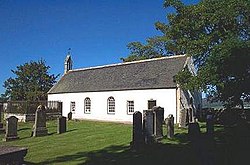
[[File:Kincardine Church - geograph.org.uk - 225510.jpg|thumb|250px|Kincardine Church]] | [[File:Kincardine Church - geograph.org.uk - 225510.jpg|thumb|250px|Kincardine Church]] | ||
| − | '''Kincardine''' is a parish 14 miles north-west of [[Tain]] in [[Ross-shire]]. It also comprehends two detached parts of [[Cromartyshire]] (Nos. 11 and 12). This place perhaps derives its name, of Celtic origin, signifying "the termination of the heights", from its situation at the extremity of some ranges of lofty hills. The parish contains the settlements of [[Ardgay]], Croik and Culrain. | + | '''Kincardine''' is a parish 14 miles north-west of [[Tain]] in [[Ross-shire]]. It also comprehends two detached parts of [[Cromartyshire]] (Nos. 11 and 12). This place perhaps derives its name, of Celtic origin, signifying "the termination of the heights", from its situation at the extremity of some ranges of lofty hills. The parish contains the settlements of [[Ardgay]], Croik and [[Culrain]]. The hamlet of Kincardine lies ¾ mile south-east of Ardgay. |
The northern border of the parish coincides with the border between [[Ross-shire]] and [[Sutherland]], whereas the southern borders are with the Ross parishes of [[Edderton]], [[Rosskeen]], [[Alness]], [[Fodderty]], [[Contin]] and [[Lochbroom]]. | The northern border of the parish coincides with the border between [[Ross-shire]] and [[Sutherland]], whereas the southern borders are with the Ross parishes of [[Edderton]], [[Rosskeen]], [[Alness]], [[Fodderty]], [[Contin]] and [[Lochbroom]]. | ||
| − | The [[River Carron, Easter Ross|River Carron]] and its tributaries from their source to the [[Kyle of Sutherland]] lie entirely within the parish. The A836 road runs along the eastern boundary and crosses the Kyle of Sutherland at [[Bonar Bridge]]. The Far North railway line from [[Inverness]] to [[Thurso]] and [[Wick]] also follows the same route but continues north to Culrain before crossing the Kyle. Railway stations are to be found at Ardgay and Culrain. | + | The [[River Carron, Easter Ross|River Carron]] and its tributaries from their source to the [[Kyle of Sutherland]] lie entirely within the parish. The A836 road runs along the eastern boundary and crosses the Kyle of Sutherland at [[Bonar Bridge]]. The Far North railway line from [[Inverness]] to [[Thurso]] and [[Wick]] also follows the same route but continues north to Culrain before crossing the Kyle at the [[Shin Railway Viaduct|Shin Viaduct]]. Railway stations are to be found at Ardgay and Culrain. |
| + | |||
| + | ==Outside links== | ||
| + | *Overview map: {{wmap|57.905|-4.685|zoom=11}} | ||
| + | *Map of Kincardine hamlet: {{wmap|57.873|-4.362|zoom=14|name=Kincardine}} | ||
[[Category:Towns and villages in Cromartyshire]] | [[Category:Towns and villages in Cromartyshire]] | ||
[[Category:Towns and villages in Ross-shire]] | [[Category:Towns and villages in Ross-shire]] | ||
{{stub}} | {{stub}} | ||
Latest revision as of 10:20, 6 October 2017
Kincardine is a parish 14 miles north-west of Tain in Ross-shire. It also comprehends two detached parts of Cromartyshire (Nos. 11 and 12). This place perhaps derives its name, of Celtic origin, signifying "the termination of the heights", from its situation at the extremity of some ranges of lofty hills. The parish contains the settlements of Ardgay, Croik and Culrain. The hamlet of Kincardine lies ¾ mile south-east of Ardgay.
The northern border of the parish coincides with the border between Ross-shire and Sutherland, whereas the southern borders are with the Ross parishes of Edderton, Rosskeen, Alness, Fodderty, Contin and Lochbroom.
The River Carron and its tributaries from their source to the Kyle of Sutherland lie entirely within the parish. The A836 road runs along the eastern boundary and crosses the Kyle of Sutherland at Bonar Bridge. The Far North railway line from Inverness to Thurso and Wick also follows the same route but continues north to Culrain before crossing the Kyle at the Shin Viaduct. Railway stations are to be found at Ardgay and Culrain.
Outside links
- Overview map: 57°54’18"N, 4°41’6"W
- Map of Kincardine hamlet: 57°52’23"N, 4°21’43"W
