Bodmin Moor

Bodmin Moor is a wild, granite moorland in north-eastern Cornwall. It covers some 80 square miles, across which are wind-scoured hills, weirdly shaped granite outcrops, hill farms, bourns and open moorland.
The name "Bodmin Moor" is relatively recent and appears to have been chosen by the Ordnance Survey in 1813. The Moor was formerly known as Fowey Moor after the River Fowey which rises within it.[1] Its Cornish name, Goen Bren, is first recorded in the 12th century.[2]

.jpg)
Contents
Geography
Dramatic granite tors rise from the rolling moorland and crown many of the hills.
The best known hills are Brown Willy, the county top of Cornwall at 1,378 feet and Rough Tor at 1,312 feet. To the southeast, Kilmar Tor and Caradon Hill are the most prominent hills.
Considerable areas of the moor are poorly drained and form marshes which in hot summers may dry out. The rest of the moor is mostly rough pasture or overgrown with heather and other low vegetation.
The Moor contains about 500 holdings with around 10,000 head of beef cattle, 55,000 breeding ewes and 1,000 horses and ponies.[3] Most of the moor is a "Site of Special Scientific Interest" and has been officially designated an "Area of Outstanding Natural Beauty" as part of the wider Cornwall AONB.[4]
Geology

Bodmin Moor is one of five granite plutons in Cornwall that make up part of the Cornubian batholith.[5] The moor was created in the Carboniferous period of geological history.


Rivers and inland waters
Bodmin Moor is the source of several of Cornwall's rivers, running to the north and south coasts and to the Tamar. The main rivers rising here, running clockwise from the north are:
- The De Lank River rises near Roughtor and flows along an irregular course before joining the Camel south of Wenford.
- The Camel rises on Hendraburnick Down and flows for 25 miles before joining the sea at Padstow on the north coast
- The Inny rises near Davidstow and flows southeast to the Tamar.
- The Tiddy rises near Pensilva and flows southeast to the River Lynher (which empties into the Tamar Estuary).
- The Fowey rises at 951 feet and flows through Lostwithiel and into the Fowey estuary on the south coast.
- The River Warleggan rises near Temple and flows south to join the Fowey.
On the southern slopes of the moor lies Dozmary Pool. It is Cornwall's only natural inland lake and is glacial in origin.
In the 20th century three reservoirs have been constructed on the moor; these are Colliford Lake, Siblyback Lake and Crowdy Reservoir which supply water for a large part of the county's population. Various species of waterfowl are resident around these waters.[6]
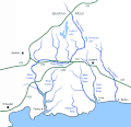
Rivers south of Bodmin Moor
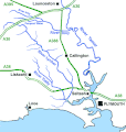
Rivers southeast of Bodmin moor
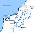
Rivers northwest of Bodmin Moor


Parishes

The parishes on the moor are:
History and antiquities


Prehistory
10,000 years ago, in the Mesolithic, hunter-gatherers wandered the moor when it was wooded and had a temperate climate. There are several documented cases of flint scatters being discovered by archaeologists, indicating that these hunter gatherers practised flint knapping in the region.[7]
During the Neolithic, from about 4,500 to 2,300 BC, men began clearing trees and farming the land. It was also in this era that the building of various megalithic monuments began, predominantly long cairns (three of which have currently been identified, at Louden, Catshole and Bearah) and stone circles (sixteen of which have been identified).
In the following Bronze Age, the creation of stone constructions increased dramatically, with the raising of over 300 further cairns, and more stone circles and stone rows.[7] More than 200 Bronze Age settlements with enclosures and field patterns have been recorded.[8] and many prehistoric stone barrows and circles lie scattered across the moor. In a programme shown in 2007 Channel 4's Time Team investigated a 500-yard cairn and the site of a Bronze Age village on the slopes of Rough Tor.[9]
King Arthur's Hall thought to be a late Neolithic or early Bronze Age site, labelled a ceremonial site until its use can be ascertained. It can be found to the east of St Breward on the moor.
Middle Ages and modern period
Where practicable areas of the moor were used for pasture by herdsmen from the parishes surrounding the moor. Granite boulders were also taken from the moor and used for stone posts and to a certain extent for building (such material is known as moorstone).[10] Granite quarrying only became reasonably effective when gunpowder became available.
The moor gave its then name (Foweymore) to one of the mediæval districts called stannaries which administered tin mining: the boundaries of these were never defined precisely. Until the establishment of a turnpike road through the moor (the present A30) in the 1770s the size of the moorland area made travel within Cornwall very difficult and made for the county's isolation.
Monuments and ruins
Roughtor was the site of a mediæval chapel of St Michael and is now designated as a memorial to the 43rd Wessex Division of the British Army.
In 1844 on Bodmin Moor the body of 18 year old Charlotte Dymond was discovered. Local labourer Matthew Weeks was accused of the murder and at noon on 12 August 1844 he was led from Bodmin Gaol and hanged. The murder site now has a monument erected from public money and the grave is at Davidstow churchyard.
Legends and traditions
Dozmary Pool is identified by some with the lake in which, according to Arthurian legend, Sir Bedivere threw Excalibur to The Lady of the Lake.[11] Another legend relating to the pool concerns Jan Tregeagle.
The Beast of Bodmin is a modern myth; a great beast described as being like a panther or some other great cat, has been reported many times but never identified with certainty.
References
- ↑ Pounds, Norman John Greville (2000). A History of the English Parish: the culture of religion from Augustine to Victoria. Cambridge University Press. pp. 593. ISBN 9780521633512.; p. 72
- ↑ Weatherhill, Craig (2009) A Concise Dictionary of Cornish Place-names. Westport, co. Mayo: Evertype; p. 6
- ↑ The Bodmin Moor Pages ~ The History
- ↑ http://www.cornwall-aonb.gov.uk/documents/12_bodmin_character.pdf
- ↑ [1] Charoy, B. (1986) Genesis of the Cornubian Batholith (South West England): the example of the Carnmenellis Pluton in: Journal of Petrology; 1986 Oxford: OUP
- ↑ Bere, Rennie (1982) The Nature of Cornwall. Buckingham: Barracuda Books, pp. 63-67
- ↑ 7.0 7.1 Tilley, C. (1996) "The Power of Rocks: landscape and topography on Bodmin Moor", in: World Archaeology; 28, p. 165
- ↑ channel4.com - Time Team - Bodmin Moor, Cornwall
- ↑ "Bodmin Moor, Cornwall". Channel 4: Time Team. 8 April 2007. http://www.channel4.com/history/microsites/T/timeteam/2007_bod_found.html. Retrieved 2009-11-09.
- ↑ Clifton-Taylor, A. "Building materials" in: Pevsner, N. (1970) Cornwall. 2nd ed. Penguin Books, p. 29-34
- ↑ Cornish Archaeology; No 34, 1995
- Weatherhill, Craig (1995) Cornish Place Names & Language. Wilmslow: Sigma Leisure ISBN 1850584621
Outside links
| ("Wikimedia Commons" has material about Bodmin Moor) |