Difference between revisions of "Beinn Bhrotain"
From Wikishire
m |
m |
||
| Line 3: | Line 3: | ||
|county=Aberdeenshire | |county=Aberdeenshire | ||
|range=Cairngorms | |range=Cairngorms | ||
| + | |SMC=8 | ||
|picture=View towards Beinn Bhrotain - geograph.org.uk - 1676851.jpg | |picture=View towards Beinn Bhrotain - geograph.org.uk - 1676851.jpg | ||
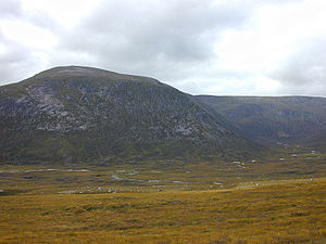
|picture caption=View across Glen Dee to Beinn Bhrotain, September 2000 | |picture caption=View across Glen Dee to Beinn Bhrotain, September 2000 | ||
Revision as of 22:10, 18 November 2013
| Beinn Bhrotain | |||
| Aberdeenshire | |||
|---|---|---|---|
 View across Glen Dee to Beinn Bhrotain, September 2000 | |||
| Range: | Cairngorms | ||
| Summit: | 3,796 feet NN954923 | ||
Beinn Bhrotain is a mountain in the Cairngorms range, in Aberdeenshire, 10 miles west of Braemar.
The mountain's name is Gaelic, and means "Hill of the mastiff".
This Mountain or hill article is a stub: help to improve Wikishire by building it up.
References
| ("Wikimedia Commons" has material about Beinn Bhrotain) |
| Munros in SMC Area SMC Section 8 - The Cairngorms |
|---|
|
Beinn a' Bhuird • Beinn a' Chaorainn • Beinn Bhreac • Beinn Bhrotain • Beinn Mheadhoin • Ben Avon • Ben Macdhui • Braeriach • Bynack More • Cairn Gorm • Cairn Toul • Carn a' Mhaim • Derry Cairngorm • Monadh Mòr • Mullach Clach a' Bhlair • Sgòr an Lochain Uaine • Sgòr Gaoith • The Devil's Point |