St Dominic, Cornwall
| St Dominic | |
| Cornwall | |
|---|---|
 St Dominic Parish Church | |
| Location | |
| Grid reference: | SX401677 |
| Location: | 50°29’20"N, 4°15’25"W |
| Data | |
| Post town: | Saltash |
| Postcode: | PL12 |
| Local Government | |
| Council: | Cornwall |
St Dominic is a village in eastern Cornwall, two and a half miles east of Callington, and five miles north of Saltash. It is within the Hundred of East Wivelshire.
The historical spelling was 'St Dominick', but this has gradually changed to drop the letter K,[1] though the K persists on Ordnance Survey mapping.

St Dominic parish is bounded by Calstock parish to the north, by the River Tamar and border with Devon to the east, by St Mellion parish to the south and by Callington parish to the west.
The parish is named after a female saint, St Dominica. The population of the parish was 774 at the 2011 census.
Parish church
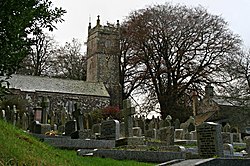
The parish church is dedicated to St Dominica and has two aisles. The south aisle is the earlier of the two; the tower (of the 13th century) is of an unusual design.[2]

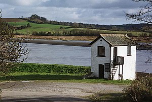
As well as St Dominic itself, which is the churchtown, the parish includes such hamlets as Burraton, Bohetheric (also known as Etheric), and Halton Quay, where there is an Anglican chapel.
Cotehele, a National Trust house and estate, is to the north of St Dominic.
References
- ↑ Information on St Dominic, Cornwall from GENUKI
- ↑ Nikolaus Pevsner: The Buildings of England: Cornwall, 1951; 1970 Penguin Books ISBN 978-0-300-09589-0
- Allen, Natalie: 'Through the Letter-box' (1988) ISBN 978-0-9508408-2-6 pages=177-179: A history of St Dominic post office