Pembroke Parish
| Pembroke Parish | |
| Bermuda | |
|---|---|
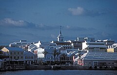
 Front Street in Hamilton | |
 | |
Pembroke Parish is one of the nine parishes of Bermuda. It is named after William Herbert, 3rd Earl of Pembroke (1580-1630).
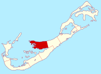
The parish occupies most of the short peninsula which juts from the central north coast of Bermuda's main island, and surrounds the city of Hamilton on three sides (the fourth being taken up by the shore of Hamilton Harbour). As such, its shape bears some passing resemblance to the county of Pembrokeshire. The peninsula juts into the eastern side of the Great Sound, the large expanse of water which dominates the geography of western Bermuda. In the east, Pembroke meets Devonshire Parish. As with most of Bermuda's parishes, it covers just over 2.3 square miles or 1,500 acres.
About the parish
Natural features in Pembroke include Spanish Point, and Point Shares, as well as numerous small islands off Point Shares.
Other notable features of Pembroke include Fort Hamilton and Government House.
Pembroke Marsh East was designated a Ramsar site on 11 May 1999.
Outside links
Coordinates: 32°17′50″N 64°46′50″W / 32.29722°N 64.78056°W
| Parishes of Bermuda |
|---|
|
Devonshire • Hamilton • Paget • Pembroke • St George's • Sandys • Smith's • Southampton • Warwick |