Ealand
| Ealand | |
| Lincolnshire | |
|---|---|
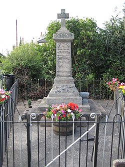
 The war memorial, Ealand | |
| Location | |
| Grid reference: | SE782112 |
| Location: | 53°35’33"N, -0°49’8"W |
| Data | |
| Population: | 4,828 (2011) |
| Post town: | Scunthorpe |
| Postcode: | DN17 |
| Local Government | |
| Council: | North Lincolnshire |
Ealand is a small village in Lindsey, Lincolnshire,. It is situated within the Isle of Axholme, a mile south-east from Crowle (where the 2011 census population is now combined as Crowle and Ealand), and ½ mile north from the junction between the A161 and the A18 roads.[1]
The Stainforth and Keadby Canal and Crowle railway station are at the southern edge of Ealand. The A161, which previously ran through the village, has been diverted, and uses a new bridge over the parallel railway line and canal.
Ealand has a Primitive Methodist chapel,[2] a war memorial, and the disused building of the previous New Trent Inn.[3] It has two Grade II listed buildings, an early to mid-18th-century house on Ealand Outgate[4] and early 19th-century Curlews farmhouse on the A161.[5]
Immediately to the west of the A161 is Seven Lakes Leisure Park, sited on clay pits of the former Crowle Brickworks.
References
- ↑ OS Explorer Map 280: Isle of Axholme, Scunthorpe and Gainsborough: (1:25 000) : ISBN 0 319 46432 6
- ↑ "Ealand Primitive Methodist Chapel", Geograph.org.uk. Retrieved 23 July 2011
- ↑ "The New Trent Inn, Ealand", Geograph.org.uk. Retrieved 23 July 2011
- ↑ National Heritage List 1083263: 61, Ealand Outgate
- ↑ National Heritage List 1083299: Curlews Farmhouse, A161
Outside links
| ("Wikimedia Commons" has material about Ealand) |
- Crowle Community Forum
- Isle of Axholme website
- "Crowle", Genuki.org.uk. Retrieved 23 July 2011
| Isle of Axholme |
|---|
|
Althorpe • Amcotts • Beltoft • Crowle • Ealand • Eastoft • Epworth • Garthorpe • Haxey • Keadby • Luddington • Owston Ferry • Sandtoft • West Butterwick • Westwoodside • Wroot |
