Brecon Beacons
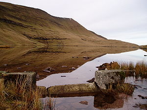
The Brecon Beacons (Welsh: Bannau Brycheiniog) are a mountain range in Brecknockshire. It forms the central section of the Brecon Beacons National Park (Parc Cenedlaethol Bannau Brycheiniog), one of Wales's three National Park.
Range

The Brecon Beacons range consists of the mountains to the south of Brecon. The highest of these is Pen y Fan (2,900 feet); other notable summits include Corn Du (2,864 feet), Cribyn (2,608 feet), and Fan y Big (2,359 feet). These summits form a long ridge which forms a horseshoe around the head of the Taf Fechan river to the south-east, with long parallel spurs extending to the north-east. The round of the Taf Fechan skyline forms a popular ridge walk known as the 'Beacons Horseshoe'. Many other fine walks exist in this part of the National Park but the mountains are known for swift changes in weather conditions, even in summer. In winter they can be dangerous.
The Brecon Beacons are named after the ancient practice of lighting signal fires on mountains to warn of attacks by enemies or marauders, or more recently to commemorate public and national events such as coronations or the Millennium.
National Park


The National Park was established in 1957, the last of the three Welsh parks, along with Snowdonia (1951) and the Pembrokeshire Coast. It covers 519 square miles (332 100 acres) stretching from Llandeilo in the west to Hay-on-Wye in the east. It encompasses the ranges confusingly named the Black Mountains (in the east of the Park, on the border with Herefordshire) and the Black Mountain (in the west). The area to the west of the Brecon Beacons range is known as Fforest Fawr (Great Forest).
The western half of the National Park gained European and Global Geopark status in 2005[1]. Fforest Fawr Geopark includes not only the historic extent of Fforest Fawr but also the Black Mountain and much of the central Brecon Beacons together with surrounding lowlands.
Most of the National Park is moorland, with some forestry plantations, and pasture in the valleys. In 1966 the Brecon Beacons Mountain Centre was opened as an interpretive facility to better enable visitors and tourists to understand and enjoy the area.
On 22 May 2005, the first walk to span the entire length of the Brecon Beacons National Park was opened. The 100 mile route, called The Beacons Way, runs from the foot of Ysgyryd Fawr east of Abergavenny, through Crickhowell and ends in the village of Bethlehem, Carmarthenshire.
Activities in the Park include walking, cycling, mountain biking, horse riding, as well as sailing, windsurfing, canoeing and fishing its rivers and reservoirs, rock climbing, hang-gliding, caravanning, camping and caving. The Taff Trail also passes through the Beacons on its way from Brecon to Cardiff.

The Park is known for its waterfalls, including the 89-foot Sgwd Henrhyd and the falls at Ystradfellte, and its caves, such as Ogof Ffynnon Ddu.

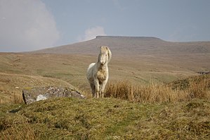
Welsh mountain ponies graze wild within the Park, as do many mountain sheep.
Due to the remoteness of some of its mountains and the weather, the Park is used for military training. The Special Air Service is known for holding especially demanding selection training exercises here such as the "Fan dance". The infantry regiments of the British Army all train at Sennybridge, where non-commissioned officer selection also takes place.

In 2006 and 2007 controversy surrounded the government decision to build the South Wales Gas Pipeline through the Park, the National Park Authority calling the decision a “huge blow”.[2]
Mountain rescue
Mountain rescue in Wales is provided by eight groups, with assistance from local police forces, and in serious situations an RAF helicopter from RAF Valley. These are:
- BMRT - Brecon Mountain Rescue Team [1]
- SARDA South Wales - Search and Rescue Dog Association covering Southern & Mid Wales [2]
- SARDA Wales - Search and Rescue Dog Association covering Northern Wales
- C/Beacons - Central Beacons
- WBMSART - Western Beacons Mountain Search and Rescue Team [3]
- LMRT - Longtown Mountain Rescue Team based in the east
- NEWSAR - North East Wales Search and Rescue [4]
- SARA - Severn Area Rescue Association
Most are staffed by local volunteers and funded primarily by donations. Their work is not restricted to mountain and wilderness rescue; teams sometimes assist the local police to search for missing or vulnerable persons in the community.
History
Over twenty hill-forts were established in the area during the Iron Age. The largest, and indeed the largest in south Wales, were the pair of forts atop Y Garn Goch near Bethlehem - Y Gaer Fawr and Y Gaer Fach - literally 'the big fort' and 'the little fort'.
When the Romans came to Wales in 43AD, they stationed more than 600 soldiers in the area. Y Gaer, near the town of Brecon was their main base.
During the Norman Conquest many castles were erected throughout the park. One of the most famous is Carreg Cennen Castle, but there are many more.

Towns and villages
}
References
Outside links
|
