Creag Leacach: Difference between revisions
Created page with '{{Infobox hill |name=Creag Leacach |county 1=Angus |county 2=Perthshire |range= |SMC=7 |picture=Creag Leacach - geograph.org.uk - 314205.jpg |picture caption= |height=3,238 feet …' |
No edit summary |
||
| Line 8: | Line 8: | ||
|picture caption= | |picture caption= | ||
|height=3,238 feet | |height=3,238 feet | ||
| | |latitude=56.8543 | ||
|longitude=-3.3874 | |||
|os grid ref=NO154745 | |os grid ref=NO154745 | ||
}} | }} | ||
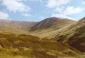
'''Creag Leacach''' is a mountain on the border of [[Angus]] with [[Perthshire]], which reaches a height of 3,238 feet at its summit, and so it qualifies as a [[Munro]]. | '''Creag Leacach''' is a mountain on the border of [[Angus]] with [[Perthshire]], which reaches a height of 3,238 feet at its summit, and so it qualifies as a [[Munro]]. | ||
Creag Leacach is normally climbed in conjunction with neighbouring [[Glas Maol]] to which is connected by Creag Leacach's | Creag Leacach is normally climbed in conjunction with neighbouring [[Glas Maol]] to which is connected by Creag Leacach's north-east ridge. The summit is unusually pointed for the hills hereabouts, with large areas of scree on both its western and eastern faces. | ||
The | The north-east ridge leads to the neighbouring Munro, Glas Maol, while the southwest ridge runs to a subsidiary peak (the Southwest Top) before splitting, and the continuing south-west ridge drops down into Glen Shee. | ||
Route finding on Creag Leacach is easy due to a dry stone wall running the length of the summit ridge directing you to the summit. | Route finding on Creag Leacach is easy due to a dry stone wall running the length of the summit ridge directing you to the summit. | ||
Latest revision as of 11:18, 16 July 2024
| Creag Leacach | |
| Angus, Perthshire | |
|---|---|

| |
| Summit: | 3,238 feet NO154745 56°51’15"N, 3°23’15"W |
Creag Leacach is a mountain on the border of Angus with Perthshire, which reaches a height of 3,238 feet at its summit, and so it qualifies as a Munro.
Creag Leacach is normally climbed in conjunction with neighbouring Glas Maol to which is connected by Creag Leacach's north-east ridge. The summit is unusually pointed for the hills hereabouts, with large areas of scree on both its western and eastern faces.
The north-east ridge leads to the neighbouring Munro, Glas Maol, while the southwest ridge runs to a subsidiary peak (the Southwest Top) before splitting, and the continuing south-west ridge drops down into Glen Shee.
Route finding on Creag Leacach is easy due to a dry stone wall running the length of the summit ridge directing you to the summit.
These hills are an easy day out and are easily accessible from the A93 near the Glenshee ski centre where there is plenty of parking available.
| Munros in SMC Area SMC Section 7 - Glenshee to Mount Keen |
|---|
|
Broad Cairn • Cairn Bannoch • Cairn of Claise • Càrn a' Choire Bhoidheach • Càrn an t-Sagairt Mor • Càrn an Tuirc • Creag Leacach • Driesh • Glas Maol • Lochnagar • Mayar • Mount Keen • Tolmount • Tom Buidhe |