River Douglas, Lancashire: Difference between revisions
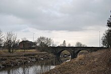
Created page with "right|thumb|270px|The River Douglas at Appley Bridge, Wigan The '''River Douglas''', also known as the '..." |
mNo edit summary |
||
| Line 39: | Line 39: | ||
*Carr Brook | *Carr Brook | ||
*Strine Brook | *Strine Brook | ||
*[[River Yarrow | *[[River Yarrow, Lancashire|River Yarrow]] | ||
==Outside links== | ==Outside links== | ||
Latest revision as of 21:29, 18 November 2014

The River Douglas, also known as the River Asland or Astland,[1] is a river 35 miels long, wholly in Lancashire, and which is ultimately is a tributary of the River Ribble. The Douglas itself takes the waters of two main tributaries; the River Tawd and the River Yarrow.
The river rises on the slopes of Winter Hill on the moorlands of the Lancashire Pennines. From here it flows south-west and down into the big towns of south Lancashire, first to Horwich and then on to Wigan. Flowing through the middle of Wigan the river is navigable, and has enabled Wigan to serve as an inland port: the famous Wigan Pier is on the Douglas.


Below Wigan the Douglas turns west and then northwest through several towns, and enventually comes to the Ribble estuary beyond Tarleton. The last 10 miles are tidal.
In 1892 the Douglas was diverted in Wigan to allow the construction of Wigan Central railway station.
In 1720 an Act of Parliament was passed allowing Thomas Steers and William Squire to make the Douglas navigable to small ships between Wigan and its mouth. Amid financial irregularities, the Douglas Navigation was not completed until 1742, and by 1783, it had been superseded by the Leeds and Liverpool Canal.[2]
The rivr reverted to being a more natural river, although the remains of several locks can still be seen between Parbold and Gathurst.[3]
The Rufford Branch of the canal joins the river at Tarleton.
Tributaries
- Longton Brook
- Centre Drain
- Carr Heys Watercourse
- Tarra Carr Gutter
- Hall Pool
- Dunkirk Dib
- Rakes Brook
- Carr Brook
- Strine Brook
- River Yarrow
Outside links
- Ribble Link Trust
- Photographs of the River Douglas
- A few views of the River Douglas in a personal 'blog'
References
- ↑ Bland, E (1903). Annals of Southport and district. A chronological history of North Meols from Alfred the Great to Edward VII. Southport: J J Riley. http://www.archive.org/details/annalsofsouthpor00blaniala.
- ↑ Charles Hadfield; Gordon Biddle (1970). The Canals of North West England, Vol 1 (pp.1-236). David and Charles. pp. 61–62, 77. ISBN 0-7153-4956-2.
- ↑ Nicholson Guides (2006). Volume 5: North West and the Pennines. p. 93. ISBN 0-00-721113-9.