Haverfordwest: Difference between revisions
No edit summary |
mNo edit summary |
||
| Line 44: | Line 44: | ||
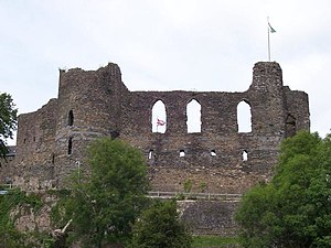
[[File:HaverfordwestCastle - geograph.org.uk - 25363.jpg|thumb|left|Haverfordwest Castle]] | [[File:HaverfordwestCastle - geograph.org.uk - 25363.jpg|thumb|left|Haverfordwest Castle]] | ||
===Origins=== | ===Origins=== | ||
Though little early archaeology has been found in Haverfordwest, Edward Llwyd's note to Camden's "Britannia" (ed. 1695) refers to a valuable find of silver coins at Llanboidy, the latest coin being one of Domitian struck in AD 91. In the 1920s Sir Mortimer Wheeler partially excavated a Roman dwelling or villa at Wolfscastle (work restarted in 2002 by Professor Merroney). The Romas were present at [[Carmarthen]] (''Maridunum'') and in 1992 aerial photography identified a Roman road running west of Carmarthen past [[Wiston]] to Poyston Cross, raising the possibility of Roman fortlets at strategic river crossings at [[Whitland]] and Haverfordwest, though none has been identified. | Though little early archaeology has been found in Haverfordwest, Edward Llwyd's note to Camden's "Britannia" (ed. 1695) refers to a valuable find of silver coins at Llanboidy, the latest coin being one of Domitian struck in AD 91. In the 1920s Sir Mortimer Wheeler partially excavated a Roman dwelling or villa at Wolfscastle (work restarted in 2002 by Professor Merroney). The Romas were present at [[Carmarthen]] (''Maridunum'') and in 1992 aerial photography identified a Roman road running west of Carmarthen past [[Wiston, Pembrokeshire|Wiston]] to Poyston Cross, raising the possibility of Roman fortlets at strategic river crossings at [[Whitland]] and Haverfordwest, though none has been identified. | ||
The strategic position of Haverfordwest with its defensive bluff overlooking the lowest fordable point on the Western Cleddau and accessible to sea traffic would have required a Roman presence, probably modest in scale, from the first century AD to protect supplies to and from the coast, and evidence of Roman activity this far west is found in [[Monmouthshire]]: the Roman legionary headquarters at [[Caerleon]] were roofed with slates from the lower slopes of the Preselly mountains. | The strategic position of Haverfordwest with its defensive bluff overlooking the lowest fordable point on the Western Cleddau and accessible to sea traffic would have required a Roman presence, probably modest in scale, from the first century AD to protect supplies to and from the coast, and evidence of Roman activity this far west is found in [[Monmouthshire]]: the Roman legionary headquarters at [[Caerleon]] were roofed with slates from the lower slopes of the Preselly mountains. | ||
| Line 54: | Line 54: | ||
The ecclesiastical centre of the area (perhaps the seat of a bishop in the Age of the Saints) was probably one of the several churches of the local St Ismael, most probably St Ishmael's.<ref>Williams, A. H., ''An Introduction to the History of Wales'': Volume I: ''Prehistoric Times to 1063'', UoWP, 1941, p 120</ref> This occurred around 1110.<ref>Miles p 12</ref> | The ecclesiastical centre of the area (perhaps the seat of a bishop in the Age of the Saints) was probably one of the several churches of the local St Ismael, most probably St Ishmael's.<ref>Williams, A. H., ''An Introduction to the History of Wales'': Volume I: ''Prehistoric Times to 1063'', UoWP, 1941, p 120</ref> This occurred around 1110.<ref>Miles p 12</ref> | ||
It is said that Haverfordwest Castle was founded by Tancred, a Flemish marcher lord. The castle is elsewhere recorded as having been founded in 1100 by the Norman Gilbert. It is recorded that the Constable of the castle in 1207 was Itohert son of Richard Tancard, possibly a descendant of the first Tancred. | It is said that [[Haverfordwest Castle]] was founded by Tancred, a Flemish marcher lord. The castle is elsewhere recorded as having been founded in 1100 by the Norman Gilbert. It is recorded that the Constable of the castle in 1207 was Itohert son of Richard Tancard, possibly a descendant of the first Tancred. | ||
Flemings settled heavily in the area; they are said to have come in three waves, in 1107, 1111 and 1151, and they developed the area. Gerald of Wales (writing during the reign of Henry II, recorded their presence in the [[Roose Hundred|Hundred of Roose]] in Pembrokeshire. | Flemings settled heavily in the area; they are said to have come in three waves, in 1107, 1111 and 1151, and they developed the area. Gerald of Wales (writing during the reign of Henry II, recorded their presence in the [[Roose Hundred|Hundred of Roose]] in Pembrokeshire. | ||
A Fleming, Wizo, who died in 1130 founded at Wiston a motte and bailey fortification, forerunner of the stone castle, for protection against the Welsh warlords: the Flemings were reportedly unpopular wherever they settled. The precarious position of Normans and Flemings was demonstrated in 1136 when the Normans, having already lost 500 men in battle at Loughor, re-recruited from Lordships from all over South Wales and led by Robert Fitz Martin at Crug Mawr near Cardigan attacked Owain Gwynedd and his army. Routed, they fled over the Teifi Bridge which collapsed; the remaining Normans drowning under the weight of their armour. Their leader Richard de Clare had previously been intercepted and killed by Iorwerth ab Owen. Wiston and the castle were overrun in 1147 by Hywel Sais, son of the Lord Rhys. Ranulf Higden in his Polychronicus records the Flemings as extinct in Pembrokeshire by 1327 but in 1400, called up by Henry IV, Flemings joined an army of 1,500 English settlers who marched north from Pembrokeshire to attack the army of Owain Glyndŵr at Mynydd Hyddgen. | A Fleming, Wizo, who died in 1130 founded at Wiston a motte-and-bailey fortification, forerunner of the stone castle, for protection against the Welsh warlords: the Flemings were reportedly unpopular wherever they settled. The precarious position of Normans and Flemings was demonstrated in 1136 when the Normans, having already lost 500 men in battle at [[Loughor]], re-recruited from Lordships from all over South Wales and led by Robert Fitz Martin at [[Crug Mawr]] near [[Cardigan]] attacked Owain Gwynedd and his army. Routed, they fled over the Teifi Bridge which collapsed; the remaining Normans drowning under the weight of their armour. Their leader Richard de Clare had previously been intercepted and killed by Iorwerth ab Owen. Wiston and the castle were overrun in 1147 by Hywel Sais, son of the Lord Rhys. Ranulf Higden in his Polychronicus records the Flemings as extinct in Pembrokeshire by 1327 but in 1400, called up by Henry IV, Flemings joined an army of 1,500 English settlers who marched north from Pembrokeshire to attack the army of Owain Glyndŵr at Mynydd Hyddgen. | ||
Haverfordwest rapidly grew, initially around the castle and St Martin's church (the settlement being called Castletown), then spreading into the High Street area. It immediately became the capital of the hundred of Roose (part of "Little England beyond Wales"), and because of its pivotal position, the commercial centre of the area, which it has remained to this day. In common with other British towns, Haverfordwest's growth was rapid during the period up to 1300, and its extent<ref>Miles p 28</ref> by then was much the same as it was in the early 19th century. That being the case, its population was probably around 4,000-5,000 - a large town by the standards of the time. It received its first charter from William Marshall, 1st Earl of Pembroke some time between 1213 and 1219, and obtained the lucrative trading privileges of an English borough. It traded both by land and sea, and had a busy tidal quay on the river below the "New" Bridge. At least ten guilds operated, and there was significant woollen cloth manufacture. On 30 April 1479, the town was designated a county corporate by a charter of Edward, Prince of Wales, with the aim of supporting a campaign against piracy in local waters. | Haverfordwest rapidly grew, initially around the castle and St Martin's church (the settlement being called Castletown), then spreading into the High Street area. It immediately became the capital of the hundred of Roose (part of "Little England beyond Wales"), and because of its pivotal position, the commercial centre of the area, which it has remained to this day. In common with other British towns, Haverfordwest's growth was rapid during the period up to 1300, and its extent<ref>Miles p 28</ref> by then was much the same as it was in the early 19th century. That being the case, its population was probably around 4,000-5,000 - a large town by the standards of the time. It received its first charter from William Marshall, 1st Earl of Pembroke some time between 1213 and 1219, and obtained the lucrative trading privileges of an English borough. It traded both by land and sea, and had a busy tidal quay on the river below the "New" Bridge. At least ten guilds operated, and there was significant woollen cloth manufacture. On 30 April 1479, the town was designated a county corporate by a charter of Edward, Prince of Wales, with the aim of supporting a campaign against piracy in local waters. | ||
Latest revision as of 14:44, 19 May 2021
| Haverfordwest Welsh: Hwlffordd | |
| Pembrokeshire | |
|---|---|
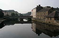
 Bridge over the Cleddau, Haverfordwest | |
| Location | |
| Grid reference: | SM955155 |
| Location: | 51°48’2"N, 4°58’2"W |
| Data | |
| Population: | 10,808 (2001) |
| Post town: | Haverfordwest |
| Postcode: | SA61, SA62 |
| Dialling code: | 01437 |
| Local Government | |
| Council: | Pembrokeshire |
| Parliamentary constituency: |
Preseli Pembrokeshire |
Haverfordwest is a town in Pembrokeshire, the county's most populous town, with a population of 13,367 in 2001.
The name of the town means "heifer ford" from Old English hæfar ("heifer").[1] In local dialect, it is pronounced "harford". The Welsh language name is said by BG Charles to be "merely a corruption of the English name", and as such has no meaning in Welsh. Another notion is that Tudor period monarchs called it "Hereford or Hertford in the West", to distinguish it from either Hereford or Hertford.
The town and its landscape


Haverfordwest serves as the market town for most of Pembrokeshire. It forms an important road network hub between other towns in the county such as Milford Haven, Pembroke Dock, Fishguard and St David's, as a result of its position at the tidal limit of the western Cleddau river.
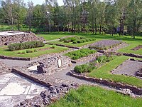
The majority of the town, comprising the parishes of St Mary, St Martin and St Thomas, lies on the western bank of the river. On the eastern bank are the suburbs of Prendergast and Cartlett. At this point, a pair of sandstone ridges extending east-west and separated by a deep, narrow valley, are cut through by the western Cleddau leaving two high spurs on the west side of the river. On the northern spur, the castle and its surrounding settlement form the core of St Martin's parish. On the southern spur, the High Street ascends steeply from the river, and forms the core of St Mary's parish. From the foot of each spur, ancient bridges cross the river to Prendergast: St Martin's Bridge ("the Old Bridge") and St Mary's Bridge ("the New Bridge", built in 1835). St Thomas's parish occupies the south side of the southern spur. From these core areas, the town has spread, mainly along the ridges. In addition to the four ancient parish churches, the remains of an Augustinian priory are visible at the southern edge of the town.
Pembrokeshire Coast National Park
Haverfordwest is six miles away from the village of Broad Haven, part of the Pembrokeshire Coast National Park. The Park is the United Kingdom's only coastal national park, which attracts thousands of tourists each year.
Churches
- Church in Wales:
- St Davids Church, Prendergast
- St Martin's
- St Mary's
- Baptist:
- Pentecostal: Calvary Church
- Roman Catholic: St David & St Patrick
History

Origins
Though little early archaeology has been found in Haverfordwest, Edward Llwyd's note to Camden's "Britannia" (ed. 1695) refers to a valuable find of silver coins at Llanboidy, the latest coin being one of Domitian struck in AD 91. In the 1920s Sir Mortimer Wheeler partially excavated a Roman dwelling or villa at Wolfscastle (work restarted in 2002 by Professor Merroney). The Romas were present at Carmarthen (Maridunum) and in 1992 aerial photography identified a Roman road running west of Carmarthen past Wiston to Poyston Cross, raising the possibility of Roman fortlets at strategic river crossings at Whitland and Haverfordwest, though none has been identified.
The strategic position of Haverfordwest with its defensive bluff overlooking the lowest fordable point on the Western Cleddau and accessible to sea traffic would have required a Roman presence, probably modest in scale, from the first century AD to protect supplies to and from the coast, and evidence of Roman activity this far west is found in Monmouthshire: the Roman legionary headquarters at Caerleon were roofed with slates from the lower slopes of the Preselly mountains.
James Phillips, in (The History of Pembrokeshire) (published 1909) records a find of Roman silver coins in Haverfordwest, the earliest dated coin a Valerian and the latest a Claudius Gothicus. The museum in which the coins were deposited has been "scattered to the winds" and the whereabouts of the coins is unknown. Phillips claimed that the pre-Norman name of Haverfordwest was Caer Alun, and that it was so named by the Emperor Maximus (the "Macsen Gwledig" of the Mabinogion). His sources are not given. A rather fanciful article in The Cambro-Briton in 1822 stated that Maximus, the last Roman Emperor of Britain, a man who for a time divided the Roman Empire with Theodorus, on withdrawing Roman legions from Britain granted civic status and Celtic names to a number of pacified Romano-British settlements, including Southampton, Chichester, Old Sarum near Salisbury, Carmarthen (Caerfyrddin) and Haverfordwest (Caer Alun). The Mabingion, not a historical source but a fine romance, says that Macsen Gwledig married Elen, a Welsh noblewoman, and granted the lands of Britain to her family.
Middle Ages

The ecclesiastical centre of the area (perhaps the seat of a bishop in the Age of the Saints) was probably one of the several churches of the local St Ismael, most probably St Ishmael's.[2] This occurred around 1110.[3]
It is said that Haverfordwest Castle was founded by Tancred, a Flemish marcher lord. The castle is elsewhere recorded as having been founded in 1100 by the Norman Gilbert. It is recorded that the Constable of the castle in 1207 was Itohert son of Richard Tancard, possibly a descendant of the first Tancred.
Flemings settled heavily in the area; they are said to have come in three waves, in 1107, 1111 and 1151, and they developed the area. Gerald of Wales (writing during the reign of Henry II, recorded their presence in the Hundred of Roose in Pembrokeshire.
A Fleming, Wizo, who died in 1130 founded at Wiston a motte-and-bailey fortification, forerunner of the stone castle, for protection against the Welsh warlords: the Flemings were reportedly unpopular wherever they settled. The precarious position of Normans and Flemings was demonstrated in 1136 when the Normans, having already lost 500 men in battle at Loughor, re-recruited from Lordships from all over South Wales and led by Robert Fitz Martin at Crug Mawr near Cardigan attacked Owain Gwynedd and his army. Routed, they fled over the Teifi Bridge which collapsed; the remaining Normans drowning under the weight of their armour. Their leader Richard de Clare had previously been intercepted and killed by Iorwerth ab Owen. Wiston and the castle were overrun in 1147 by Hywel Sais, son of the Lord Rhys. Ranulf Higden in his Polychronicus records the Flemings as extinct in Pembrokeshire by 1327 but in 1400, called up by Henry IV, Flemings joined an army of 1,500 English settlers who marched north from Pembrokeshire to attack the army of Owain Glyndŵr at Mynydd Hyddgen.
Haverfordwest rapidly grew, initially around the castle and St Martin's church (the settlement being called Castletown), then spreading into the High Street area. It immediately became the capital of the hundred of Roose (part of "Little England beyond Wales"), and because of its pivotal position, the commercial centre of the area, which it has remained to this day. In common with other British towns, Haverfordwest's growth was rapid during the period up to 1300, and its extent[4] by then was much the same as it was in the early 19th century. That being the case, its population was probably around 4,000-5,000 - a large town by the standards of the time. It received its first charter from William Marshall, 1st Earl of Pembroke some time between 1213 and 1219, and obtained the lucrative trading privileges of an English borough. It traded both by land and sea, and had a busy tidal quay on the river below the "New" Bridge. At least ten guilds operated, and there was significant woollen cloth manufacture. On 30 April 1479, the town was designated a county corporate by a charter of Edward, Prince of Wales, with the aim of supporting a campaign against piracy in local waters.

In common with other large towns in Britain, Haverfordwest was hit hard by the Black Death in 1348, suffering both depopulation (perhaps by more than 50%) and diminution of trade. Large parts of the town were abandoned, and it did not start to recover until the Tudor period. At the end of the 17th century,[5] the town was still significantly smaller than in 1300. In 1405, the town was burned by the French allies of Owen Glendower, although in its early history Haverfordwest suffered less than most towns in Wales from such depredations.
Post-mediæval
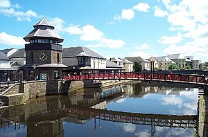
During the English Civil War, the burgesses of the borough supported Parliament, while the ruling gentry were Royalist. As a result, there was considerable conflict, and the town changed hands five times.[6] There followed a period of stagnation in which the comparative status of the town declined. Haverfordwest today has the air of a typical small country market town, but the centre still conveys the feel of the important mediæval borough. The once run-down riverside area has been renovated and Bridge Street has been pedestrianised and improved.
The town has been English-speaking for centuries (south Pembrokeshire being known as 'Little England Beyond Wales'), but because the town markets traded the goods of Welsh farmers to the north and east, there has always been a significant Welsh-speaking influence and the air of a "frontier" town.
Bibliography
- Dillwyn Miles (ed) A History of Haverfordwest, Gomer, 1999, ISBN 1-85902-738-5,
References
Outside links
- Haverfordwest Town Museum
- Photographs of Haverfordwest Panoramic photos of Haverfordwest.
- www.geograph.co.uk : photos of Haverfordwest and surrounding area