Ayre Sheading: Difference between revisions
Created page with "right|thumb|300px|Beach at the Point of Ayre File:Ayre Sheading - Isle of Man.svg|right|thumb|200px|Ayre Sh..." |
No edit summary |
||
| (One intermediate revision by the same user not shown) | |||
| Line 2: | Line 2: | ||
[[File:Ayre Sheading - Isle of Man.svg|right|thumb|200px|Ayre Sheading]] | [[File:Ayre Sheading - Isle of Man.svg|right|thumb|200px|Ayre Sheading]] | ||
{{territory|Isle of Man}} | {{territory|Isle of Man}} | ||
'''Ayre''' is one of six sheadings into which the [[Isle of Man]] is divided, and consists of the | '''Ayre''' is one of six sheadings into which the [[Isle of Man]] is divided, and consists of the ancient parishes of [[Andreas Parish|Andreas]], [[Bride Parish|Bride]] and [[Lezayre]]. | ||
Ayre is the northernmost of the six sheadings, reaching from the island’s northernmost headland, the [[Point of Ayre]], inland to [[Snaefell]] | Ayre is the northernmost of the six sheadings, reaching from the island’s northernmost headland, the [[Point of Ayre]], inland to [[Snaefell]]. | ||
==Name== | ==Name== | ||
| Line 10: | Line 10: | ||
==Location== | ==Location== | ||
*Location map: {{wmap|54.327|-4.444}} | *Location map: {{wmap|54.327|-4.444|zoom=12}} | ||
==References== | ==References== | ||
{{reflist}} | {{reflist}} | ||
{{Manx parishes}} | |||
[[Category:Sheadings of the Isle of Man]] | [[Category:Sheadings of the Isle of Man]] | ||
Latest revision as of 09:53, 17 June 2020


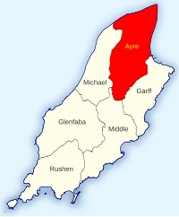
Ayre is one of six sheadings into which the Isle of Man is divided, and consists of the ancient parishes of Andreas, Bride and Lezayre.
Ayre is the northernmost of the six sheadings, reaching from the island’s northernmost headland, the Point of Ayre, inland to Snaefell.
Name
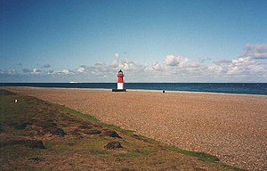
The name of the sheading is taken from it headland, now known as the Point of Ayre, and this name in turn is from the Old Norse "eyrr", meaning a shingle beach. The word typically refers to a storm beach forming a narrow spit of shingle or sand cutting across the landward and seaward ends of a shallow bay. This may partly cut off a sheltered stretch of water from the sea to form a shallow freshwater loch.[1] This word is still in use for the particular landform in Orkney and in Shetland.
Location
- Location map: 54°19’37"N, 4°26’38"W
References
- ↑ "Voes, Ayres and Beaches" Scottish Natural Heritage. Retrieved 12 October 2007.
| Sheadings and parishes of the Isle of Man |
|---|
|
Ayre: Andreas • Bride • Lezayre – Garff: Lonan • Maughold – Glenfaba: German • Marown • Patrick – Michael: Ballaugh • Jurby • Michael — Middle: Braddan • Onchan • Santon — Rushen: Arbory • Malew • Rushen |
