Lydgate, Saddleworth: Difference between revisions
Jump to navigation
Jump to search
Created page with '{{Infobox town |name=Lydgate |county=Yorkshire |riding=West Riding |picture=Lydgate, Saddleworth - geograph.org.uk - 5538.jpg |picture caption=Lydgate |os grid ref=SD97260451 |la…' |
mNo edit summary |
||
| Line 6: | Line 6: | ||
|picture caption=Lydgate | |picture caption=Lydgate | ||
|os grid ref=SD97260451 | |os grid ref=SD97260451 | ||
|latitude=53.536594 | |latitude=53.536594 | ||
|longitude=-2.041771 | |longitude=-2.041771 | ||
|post town=Oldham | |post town=Oldham | ||
Latest revision as of 18:14, 12 April 2011
| Lydgate | |
| Yorkshire West Riding | |
|---|---|
 Lydgate | |
| Location | |
| Grid reference: | SD97260451 |
| Location: | 53°32’12"N, 2°2’30"W |
| Data | |
| Post town: | Oldham |
| Postcode: | OL3 |
| Dialling code: | 01457 |
| Local Government | |
| Council: | Oldham |
| Parliamentary constituency: |
Oldham East and Saddleworth |
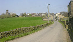
Lydgate is a village Saddleworth in the West Riding of Yorkshire. It lies east of the spreading conurbation, but contiguous with Grasscroft.
The long Lydgate Tunnel emerges here, which used to carry the railway line beneath the hill to join the main line at Greenfield Station. While the main line is still open, the tunnel lies abandoned.

This West Riding of Yorkshire article is a stub: help to improve Wikishire by building it up.
| Villages and hamlets of Saddleworth |
|---|
|
Austerlands • Castleshaw • Delph • Denshaw • Diggle • Dobcross • Friezland • Grasscroft • Greenfield • Grotton • Heights • Lydgate • Scouthead • Springhead • Uppermill |