Berwyn Range: Difference between revisions
No edit summary |
|||
| Line 1: | Line 1: | ||
[[File:Cadair_Berwyn.jpg|right|thumb|300px|Cadair Berwyn, with Llyn Lluncaws in the foreground]] | [[File:Cadair_Berwyn.jpg|right|thumb|300px|Cadair Berwyn, with Llyn Lluncaws in the foreground]] | ||
The '''Berwyn range''' ({{lang|cy|Y Berwyn}}) is an isolated and sparsely populated area of moorland located in | The '''Berwyn range''' ({{lang|cy|Y Berwyn}}) is an isolated and sparsely populated area of moorland located in north-eastern [[Wales]], on the boundaries of [[Merionethshire]] with [[Denbighshire]] and [[Montgomeryshire]]. The range roughly bounded by [[Llangollen]] in the north-east, [[Corwen]] in the north-west, [[Bala]] in the south-west, and [[Oswestry]] in the south-east. | ||
The Berwyn range should not be underestimated, as it was by King Henry II; the mountains caused him to turn back during his invasion of [[Gwynedd]] in 1165. Rather than taking the usual route along the northern coastal plain, his army invaded from [[Oswestry]] and took a route over the Berwyns. The English invasion faced an alliance of Welsh princes led by King Owain Gwynedd, but there was little fighting - endless days of heavy rain forced the army to retreat. | The Berwyn range should not be underestimated, as it was by King Henry II; the mountains caused him to turn back during his invasion of [[Gwynedd]] in 1165. Rather than taking the usual route along the northern coastal plain, his army invaded from [[Oswestry]] and took a route over the Berwyns. The English invasion faced an alliance of Welsh princes led by King Owain Gwynedd, but there was little fighting - endless days of heavy rain forced the army to retreat. | ||
| Line 22: | Line 22: | ||
The mountain lies on main ridge of the Berwyns which runs north–south. The eastern side of the ridge is characterised by steep drops and crags including Craig Berwyn north of the summit and Craig y Llyn to the south. Craig y Llyn forms the headwall of a curved corrie, and it is to this that the word ''cadair'' (chair in Welsh) presumably refers. Further north along the ridge is Cadair Bronwen, whilst to south the ridge continues to Moel Sych. | The mountain lies on main ridge of the Berwyns which runs north–south. The eastern side of the ridge is characterised by steep drops and crags including Craig Berwyn north of the summit and Craig y Llyn to the south. Craig y Llyn forms the headwall of a curved corrie, and it is to this that the word ''cadair'' (chair in Welsh) presumably refers. Further north along the ridge is Cadair Bronwen, whilst to south the ridge continues to Moel Sych. | ||
The highest point of the Berwyns has been a matter of which the understood position has twice been overtuerned by later measurement. It was long held that [[Moel Sych]] was the highest point, but later [[Ordnance Survey]] measurement showed it to be of equal height to the marked summit of [[Cadair Berwyn]] less than a mile to the north, at 2,713 feet. However a later walker | The highest point of the Berwyns has been a matter of which the understood position has twice been overtuerned by later measurement. It was long held that [[Moel Sych]] was the highest point, but later [[Ordnance Survey]] measurement showed it to be of equal height to the marked summit of [[Cadair Berwyn]] less than a mile to the north, at 2,713 feet. However a later walker discovered that the marked summit of Cadair Berwyn, where the trig point stands, is overtopped by another point on the ridge about 200 yards to the south which is over 10 feet higher; the South Top or "Cadair Berwyn New Top". | ||
Several other significant summits in the Berwyns are listed in the hill lists, including [[Foel Wen]] and [[Mynydd Tarw]]. | Several other significant summits in the Berwyns are listed in the hill lists, including [[Foel Wen]] and [[Mynydd Tarw]]. | ||
Latest revision as of 10:14, 4 September 2014

The Berwyn range (Welsh: Y Berwyn) is an isolated and sparsely populated area of moorland located in north-eastern Wales, on the boundaries of Merionethshire with Denbighshire and Montgomeryshire. The range roughly bounded by Llangollen in the north-east, Corwen in the north-west, Bala in the south-west, and Oswestry in the south-east.
The Berwyn range should not be underestimated, as it was by King Henry II; the mountains caused him to turn back during his invasion of Gwynedd in 1165. Rather than taking the usual route along the northern coastal plain, his army invaded from Oswestry and took a route over the Berwyns. The English invasion faced an alliance of Welsh princes led by King Owain Gwynedd, but there was little fighting - endless days of heavy rain forced the army to retreat.
Shape of the land


The area is wild and largely vegetated by heather about three feet thick, with some acidic grassland and bracken. It is not very popular for hill-walking or scrambling since the peaks are lower than those in Snowdonia to the west. However, the topmost peaks are rugged and have a distinctive character well worth exploring.
Nearby towns include Llangollen and Corwen, which are popular tourist destinations.
The main summits are:
- Cadair Berwyn:
- North Top (2,713 feet)
- South Top (2,726 feet)
- Moel Sych (2,713 feet)
- Cadair Bronwen (2,572 feet)
The Berwyn range is crossed to the south-west by the Milltir Cerrig mountain pass, carrying the B4391 at an altitude of 1,594 feet above sea level.
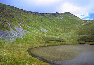
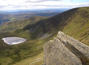
The mountain lies on main ridge of the Berwyns which runs north–south. The eastern side of the ridge is characterised by steep drops and crags including Craig Berwyn north of the summit and Craig y Llyn to the south. Craig y Llyn forms the headwall of a curved corrie, and it is to this that the word cadair (chair in Welsh) presumably refers. Further north along the ridge is Cadair Bronwen, whilst to south the ridge continues to Moel Sych.
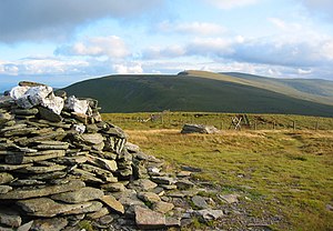
The highest point of the Berwyns has been a matter of which the understood position has twice been overtuerned by later measurement. It was long held that Moel Sych was the highest point, but later Ordnance Survey measurement showed it to be of equal height to the marked summit of Cadair Berwyn less than a mile to the north, at 2,713 feet. However a later walker discovered that the marked summit of Cadair Berwyn, where the trig point stands, is overtopped by another point on the ridge about 200 yards to the south which is over 10 feet higher; the South Top or "Cadair Berwyn New Top".
Several other significant summits in the Berwyns are listed in the hill lists, including Foel Wen and Mynydd Tarw.
There is a standing stone in the area, located near the summit between Cadair Berwyn and Tomle. This was re-erected in June 2008 by High Sports at SJ080337.
Wildlife
The area supports substantial populations of upland birds including raptors, such as the hen harrier, merlin, and Peregrine falcon (about 14-18 breeding pairs of each species, 1%–2% of the total British population),[1] and for this reason it is a Special Protection Area. Other wild birds include the short-eared owl, raven, buzzard, and golden plover.
Polecats are native to the hills too.
Name of the range
The scholar T Gwynn Jones suggested that a possible origin of the term "Berwyn" was "Bryn(iau) Gwyn (ap Nudd)", where the Middle Welsh word "bre" (hill) had mutated to Ber + Gwyn, Gwyn ap Nudd being the mythological King of the Tylwyth teg (Fair Folk, or fairies). [2]
A more likely etymology is bar gwyn"' ("white sunmmit / crest"). [3]
Supposed UFO crash
At 8.38 p.m. on 23 January 1974, an earthquake of magnitude 3.5 was felt over a wide area of north Wales and as far as Liverpool. Since earthquakes are uncommon in Britain, it was not generally recognized for what it was, and since a number of unusual lights in the sky had been observed the same evening, it was considered possible that an aircraft had crashed, or a meteorite had struck.
Further confusion was caused by lights seen on the Berwyn Mountains, which subsequently turned out to have belonged to poachers.[4] The story spread that a Flying Saucer had crashed in the hills, a tale which did not quite subside even when the incident was shown to be no more than an earthquake.
References
- ↑ "Berwyn". Joint Nature Conservation Committee. http://jncc.defra.gov.uk/page-2057-theme=default. Retrieved June 29, 2011.
- ↑ T. Gwynn Jones, Welsh Folklore and Folk-Custom (1930; new edition 1979). Several other place names in the area also include the element 'Gwyn'.
- ↑ D. Geraint Lewis, Y Llyfr Enwau - Enwau'r Wlad: A check-list of Welsh Place Names (2007).
- ↑ Roberts, Andy (2001). "The Berwyn Mountain UFO Crash – A British Roswell?". Flying Saucery Presents ... The Real UFO Project. http://www.uk-ufo.org/condign/berwart.htm. Retrieved 12 October 2009.