Woodhall, Yorkshire
Jump to navigation
Jump to search
| Woodale | |
| Yorkshire North Riding | |
|---|---|
 Woodale and Coverdale | |
| Location | |
| Grid reference: | SE021793 |
| Location: | 54°12’34"N, 1°58’6"W |
| Data | |
| Postcode: | DL8 |
| Local Government | |
| Council: | North Yorkshire |
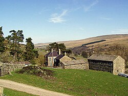
Woodale is a hamlet in Coverdale in the Yorkshire Dales in the North Riding of Yorkshire. The dale runs down in a straight line bearing the River Cover to Wensleydale, but Woodhall is high up in the dale. It is in the ancient area of the Riding known as Richmondshire.[1][2]
The name 'Woodale' stems from Old English and means 'Valley of the Wolves'.[3]
The hamlet should not be confused with the even smaller settlement of Woodale in the parish of Stonebeck Up in upper Nidderdale. The two places are only four miles apart.
References
- ↑ Information on Woodhall, Yorkshire from GENUKI
- ↑ A History of the County of York: North Riding - Volume 1 pp 214-225: Parishes: Coverham (Victoria County History)
- ↑ Ekwall, Eilert, The Concise Oxford Dictionary of English Place-Names. Oxford, Oxford University Press, 4th edition, 1960. p. 530 ISBN 0198691033