Wombourne
| Wombourne | |
| Staffordshire | |
|---|---|

| |
| Location | |
| Location: | 52°31’49"N, 2°11’8"W |
| Data | |
| Population: | 14,157 (2011) |
| Post town: | Wolverhampton |
| Postcode: | WV5 |
| Local Government | |
| Council: | South Staffordshire |
| Parliamentary constituency: |
South Staffordshire |
Wombourne (also spelt Wombourn) is a town and parish in southern Staffordshire, four miles south-west of Wolverhampton, lying just outside the conurbation.
Etymology and usage
The Old English word burna signifies a stream, and a stream is a notable feature of the village. Formerly the village name was thought to mean "Womb Stream", or stream in a hollow,[1] because this is a reasonable description of the situation. However, more recent scholarship explains the name as meaning a Crooked Stream,[2] which is at least as good a description.
Burna was one of the terms for a stream used in the earliest Anglo-Saxon place names, and the stream was presumably itself called the Wom Bourn. However, today it is always distinguished from the village by the name Wom Brook, from another, slightly later, Old English term for a stream: brōca. The Wom Brook, which has required considerable work to ameliorate its flooding, originates on Penn Common and is a tributary of the Smestow Brook, which it meets just south of Wombourne.
The spelling "Wombourne" is now preferred for official use. However, the village is marked "Wombourn" on the 1775 William Yates Map of the County of Stafford and as late as the 1945–48 series Ordnance Survey maps.[3] There has been considerable feeling about the issue and road signs were regularly amended unofficially with spray paint until the 1990s at least.
History
Origins

The village has Anglo-Saxon origins, and was part of the large central kingdom of Mercia, which was settled by Angles. The whole region was wooded when the Germanic settlers arrived, and hamlet names like Bratch ("newly-cleared-land) and Blakeley ("dark clearing") attest to the need to clear land for settlement. The settlers reared large herds of pigs, which were easily fed in the beech, oak and birch woods, which are the naturally-predominant vegetation in the region. Local toponyms like Kingswinford ("royal pig crossing") and Swindon ("pig hill") confirm the importance of pig rearing in Anglo-Saxon times.
The mediæval village
Wombourne is mentioned in Domesday Book and was clearly a medium-sized village by the standards of the time. Before the Norman Conquest, it was owned by an Anglo-Saxon nobleman called Thorsten. By the time of the survey, probably 1086, William, Fitz Ansculf, held seven hides of land, some of them let from him by one Ralph of Wombourne. William was an important landowner throughout the West Midlands, the son of Ansculf of Picquigny, a Picard baron who came to England with William the Conqueror and built a castle at Dudley. William's total holding at Wombourne supported 8 ploughs and was worth £3. There were 13 villagers (probably not including dependents, so perhaps thirty to forty people in total); a priest, and so perhaps some sort of church; as well as two mills, the first evidence for the importance of water power in the area. Wombourne was recorded as part of the Seisdon Hundred.
The Priors of Dudley built or rebuilt the Parish Church of St Benedict Biscop around 1170, the only parish church dedicated to this Anglo-Saxon cleric. The building as it is seen today, however, is the result of numerous reconstructions and refurbishments, particularly in the 18th and 19th centuries. The parish of Wombourne extended far from the village, taking in Orton and Swindon.

Industrial developments
For most of its history Wombourne was mainly an agricultural village. However, its involvement with industry began unusually early. From the Middle Ages, the Smestow Brook and the Stour were lined with small iron bloomeries and forges, using local reserves of charcoal and water. The Industrial Revolution brought coke-fired furnaces. In 1772, the Staffordshire and Worcestershire Canal was opened, with major canal locks at the Bratch and Bumble Hole, integrating the area more closely into industrial Britain. Iron production concentrated in a smaller number of centres – at Swindon, in the southern part of the Wombourn parish, at Gothersley, at the Hyde near Kinver, and increasingly in the nearby Black Country – using the canal to bring ore, coal and limestone to the works. Other villages, however, remained centres for smithing, with cheaper and more available iron greatly increasing the number of workers. Increasingly, Wombourne became a centre for nail-making. The Wom and the Smestow continued to provide both power and cooling water, with several large mills along each stream by the late 18th century.
Perhaps the largest water-driven forge was to the west of the village, where, an 1817 history remarks, "has been erected an iron-work called the Heath-forge, with genteel mansion".[4] This works had a large mill pool, supplied by the Merryhill Brook and by a contour canal from the River Smestow. Water fell thence in several stages to the Wom, which then joined the Smestow a short distance to the west. The forge mill was later converted into a corn mill, which functioned until the 1930s. The Heath Mill industrial estate on the main Bridgnorth road preserves the name of the complex. The mansion building, now converted into flats, is still to be seen in the Poolhouse estate, itself named after the poolhouse that stood at the dam. The water mill is clearly marked on the 1775 Yates map of Staffordshire, along with one at the Wodehouse, and another just south of the village centre, the remains of which are now the Pool Dam.
It was around the same time that the Hellier family reached the peak of their influence in the area. The Helliers lived at the Wodehouse, on the Wom Brook, to the east of the village. It was the fourth Samuel Hellier, knighted in 1762, who turned the Jacobean house into a centre of culture. He had the grounds laid out in fashionable style, with a hermitage, a temple to the memory of Handel, and a music room. He spent a fortune on musical instruments and books of music,[5] building up a private collection and endowing both the church at Wombourne and St John's, Wolverhampton. The family collection included the Stradivarius named after them. Dying without issue in 1784, he left his property to a family friend, the Reverend Thomas Shaw, on condition he change his name to Hellier. One of his descendents spent years as commandant of the Royal Military School of Music at Kneller Hall. It is claimed that the Wodehouse has not been sold for over 900 years.[6]
In 1851, Wombourne was described by William White as a large village, "occupied chiefly by nailors, who work for the neighbouring manufacturers".[7] Nail-making remained important into the 20th century. As White implies, it was mainly the preserve of outworkers, who operated small-scale machinery in, or attached to, their own homes, fetching iron sheet or rod from the foundries and returning the finished product.
White tells us that the main landowners in the area in the mid-19th century were John Wrottesley, 2nd Baron Wrottesley, a notable astronomer, and Lord Ward – at this time the Reverend William Humble Ward, the tenth Baron, a relative of the Earl of Dudley. The Wards made their wealth not merely from land, but what lay under it: the coal and limestone of the West Midlands. Another important landowner, the Reverend William Dalton, was an Evangelical clergyman from Ulster, but he owed his wealth to marriage to the widow of a Bilston iron master.[8]
The modern village
Although the parish had a population approaching 2000 by the mid-19th century, the village itself remained quite small – essentially confined to the area around the present village green. The hamlets of Giggetty, Blakeley, Ounsdale, and the Bratch were quite separate from the village and were only absorbed into it as suburban housing spread from the mid-20th century. This changed the whole character and structure of the village.
The area around the green, the original village of Wombourne, evolved as the commercial and cultural centre. The green was surrounded by small, independent shops, which remain a distinctive feature of the village's commercial life. A new civic centre, housing local council services, was constructed near Lower End, just south west of the centre. Suburban housing grew to form a wide ring around it, absorbing most of the hamlets.
In the 1950s, several hundred council houses were built around Wombourne by Wolverhampton council as part of an overspill rehousing programme for residents of the large town's slums.[9]
Large housing developments of the 1960s and 1970s around Giggetty and Brickbridge, to the west, were followed by a still larger westward extension in the Poolhouse estate of the 1980s, which absorbed the former Heath Mill. Meanwhile, light industry developed along the canal and the River Smestow, particularly beyond the main Bridgnorth Road, with industrial estates replacing former foundries. A new bypass was driven through to the south of the village in 1988, carrying Bridgnorth and Telford traffic around Wombourne and Himley, and clearly separating much of the industrial area from the residential section. Housing development continued into the new millennium, with building to the west of the canal between Ounsdale and the Bratch.
Today the village population works partly locally, and partly in the larger centres of Wolverhampton, the Black Country, Birmingham and Telford.
Amenities

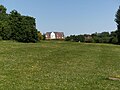
The Staffordshire and Worcestershire Canal runs north-south through the western side of the village and Bratch Locks are located just to the north-west. Another popular local spot is the South Staffordshire Railway Walk, which follows the path of a now disused railway (it served as a goods railway prior to the 1960s and as a passenger line for a few years between the two wars). Wombourne Village Green is considered to resemble an archetypal 'English village', as it is in the centre of the village and opposite St Benedict's Church. It regularly plays host to local cricket matches.
The main commercial area is around the village green and on the neighbouring streets. This contains a considerable range of small, independent shops, as well as banks, cafes and other services. There are also small developments of shops and services in the outlying areas of the village, particularly at Giggetty and Blakeley.
The village is served by a wide variety of churches, many based around the village green, which do much in the way of maintaining village traditions and in serving the more needy people in the parish. There was considerable volunteer support for the mental health centre in Planks Lane before it closed. The Hand in Hand Centre is well-supported by Christians and a number of activities for older members of the village are run and paid for by volunteers.
Walks and Local Countryside
-
 Lower End Bridge, just south-west of the village centre, marks the eastern edge of the Ham Meadow section.
 -
 Ham Meadow, south-west of the village centre, through which flows the Wom Brook.
 -
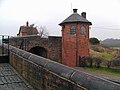 The nearby Bratch Locks.
 -
 Wombourne Railway Station on the South Staffordshire Railway Walk.


A number of important footpaths cross Wombourne, constituting an important leisure amenity as well as providing safe access to the village and surrounding countryside for walkers and cyclists.
The Wom Brook Walk

The Wom Brook Walk is a Local Nature Reserve entirely within the boundaries of the village. It stretches for about a mile and a half along both sides of the Wom Brook, traversing the village from east to west. It contains a mix of meadow and woodland. It was established after some years of work by a local conservation group, the Friends of Wom Brook. There has been great excitement over the arrival of Wombourne's very first Little Egret in October/November 2010. It was seen hunting and roosting around the Wombrook on a number of occasions and Daniel Traynor captured the very first image of the bird which was later shown in the Parish News.[10]
The South Staffordshire Railway Walk
The South Staffordshire Railway Walk is another Local Nature Reserve. It follows the course of the former Wombourne Branch Line, traversing Wombourne from north to south, before swinging east towards Himley and Dudley. It intersects with the Wom Brook Walk at the western end of Ham Meadow. To the north, it connects with the Wolverhampton Railway Walk, affording a pedestrian route into Wolverhampton via the Smestow Valley LNR. The former Wombourne station at the Bratch has car parking facilities, as well as a café and information.
The Staffordshire and Worcestershire Canal
The tow path of the Staffordshire and Worcestershire Canal also runs north-south through the western part of Wombourne, roughly parallel with the South Staffordshire Railway Walk and intersecting with the Wom Brook Walk at Giggetty. It forms part of a conservation area and can be followed as far as Kidderminster and Stourport-on-Severn to the south and Wolverhampton and Stafford to the north. It is said that once a year the phantom ghost train runs through Wombourne, with many of the local residents claiming they have both seen and heard it.
Sport
Wombourne V.C. was founded in 1995 and currently competes in the West Midlands Volleyball Association. The club has recently moved to train and compete at the brand new Evolve building near Dudley town centre. At the conclusion of the 2015 season the club was named "Volleyball England Club of the Year", topping competition from across England.[11]
References
- ↑ W. H. Duignan, Notes on Staffordshire Place Names, Henry Frowde, London, 1902.
- ↑ Margaret Gelling, Place-names in the Landscape, Dent, London, 1984, ISBN 0-460-86086-0, p.17-18, 325
- ↑ Viewed at Staffordshire Past Track
- ↑ William Pitt: A Topographical History of Staffordshire, Newcastle-under-Lyme, 1817, p.187.
- ↑ Catherine Frew and Arnold Myers, Sir Samuel Hellier's 'Musicall Instruments', Galpin Society Journal, vol. 56, June 2003.
- ↑ "Friends of Broadfield House". From the Stourbridge News, 18 May 2007
- ↑ William White, History, Gazetteer and Directory of Staffordshire, Sheffield, 1851
- ↑ Peter Hickman, The Remarkable Story of the Reverend William Dalton, Wolverhampton History and Heritage Web Site, accessed 9 February 2014.
- ↑ [1]
- ↑ South Staffordshire Council Web site, Wom Brook Walk Friends Group page, accessed 1 June 2009.
- ↑ http://www.blackcountrybugle.co.uk/Wombourne-crowned-country-s-best-volleyball-club/story-26440911-detail/story.html
Further reading
- May Griffiths. Around Pattingham & Wombourne in Old Photographs. 1992
- May Griffiths. Wombourne What Was. 1990
- WHiG (Wombourne History Group). Made in Wombourne. Ellingham Press, 2014
- WHiG (Wombourne History Group). "Wombourne Worthies and those who were not". Ellingham Press 2016
Outside links
| ("Wikimedia Commons" has material about Wombourne) |
- Wombourne.net Local Website for Wombourne
- Wombourne News Local Digital Newspaper for Wombourne
- Staffordshire Past Track Maps, photos and historic documents for all areas of the county.
- Genuki page for Wombourne, with links to local history resources.
- South Staffordshire District Council
- Wombourne Online Community Website for Wombourne