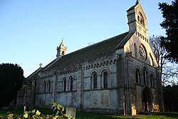
Thorney, Nottinghamshire
| Thorney | |
| Nottinghamshire | |
|---|---|
 St Helen's Church | |
| Location | |
| Location: | 53°14’50"N, -0°42’51"W |
| Data | |
| Population: | 248 (2011) |
| Post town: | Newark |
| Postcode: | NG23 |
| Local Government | |
| Council: | Newark and Sherwood |
| Website: | Thorney parish council] |
Thorney is a village and parish in the Newark Wapentake of Nottinghamshire, adjacent to the border with Lincolnshire. In 2011, the parish had a population of 248.[1] The civil parish is adjacent to those of Wigsley, Kettlethorpe, Newton on Trent, Saxilby with Ingleby, Harby, North Clifton, South Clifton and Hardwick.[2]
Features
There are six listed buildings in Thorney.[3]
History
The name "Thorney" means 'Enclosure of thorn-trees'.[4] Thorney was recorded in the Domesday Book as Torneshaie.[5] The ancient parish also includes the townships of Broadholme and Wigsley[6] which became separate civil parishes in 1866.[7][8] Iron Age, Bronze age and Roman settlements have been found. There was a Saxon settlement in around AD 500. In 1853 the manor belonged to Rev. Christopher Nevile but was previously owned by the Nevile family.
References
- ↑ "Thorney Parish". Noims. https://www.nomisweb.co.uk/reports/localarea?compare=E04007949. Retrieved 10 March 2019.
- ↑ "Thorney". Ordnance Survey. http://data.ordnancesurvey.co.uk/doc/7000000000007833. Retrieved 10 March 2019.
- ↑ "Listed Buildings in Thorney, Newark and Sherwood, Nottinghamshire". British Listed Buildings. https://britishlistedbuildings.co.uk/england/thorney-newark-and-sherwood-nottinghamshire. Retrieved 10 March 2019.
- ↑ "Thorney Key to English Place-names". The University of Nottingham. http://kepn.nottingham.ac.uk/map/place/Nottinghamshire/Thorney. Retrieved 10 March 2019.
- ↑ "Nottinghamshire S-Z". The Domesday Book Online. http://www.domesdaybook.co.uk/nottinghamshire3.html#thorney. Retrieved 10 March 2019.
- ↑ "Thorney". GENUKI. https://www.genuki.org.uk/big/eng/NTT/Thorney. Retrieved 10 March 2019.
- ↑ "Relationships and changes Broadholme Hmlt/CP through time". A Vision of Britain through Time. http://visionofbritain.org.uk/unit/10257281. Retrieved 10 March 2019.
- ↑ "Relationships and changes Wigsley CP/Hmlt through time". A Vision of Britain through Time. http://visionofbritain.org.uk/unit/10271381. Retrieved 10 March 2019.
Outside links
| ("Wikimedia Commons" has material about Thorney, Nottinghamshire) |
- "Parishes: Thorney". British History Online. https://www.british-history.ac.uk/thoroton-notts/vol1/pp382-384. Retrieved 15 March 2019.