South Hinksey
| South Hinksey | |
| Berkshire | |
|---|---|
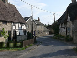
 Cottages in South Hinksey | |
| Location | |
| Grid reference: | SP5004 |
| Location: | 51°44’10"N, 1°15’50"W |
| Data | |
| Population: | 383 (2001) |
| Post town: | Oxford |
| Postcode: | OX1 |
| Dialling code: | 01865 |
| Local Government | |
| Council: | South Oxfordshire |
| Parliamentary constituency: |
Oxford West and Abingdon |
| Website: | southhinksey.org |
South Hinksey is a village in northern Berkshire found lying on the banks of the Hinksey Stream, a stream which parts from the Thames and rejoins it after a few miles. South Hinksey is close to the spread of the Oxford suburbs, trespassing over into Berkshire, and just over a mile south of the centre of Oxford. The parish includes the residential area of Hinksey Hill about half a mile south of the village.
The Oxford ring road's Southern By-Pass Road passes through the parish.
The only road access to the village is by way of the bypass. It is on the inside of the ring road and close to the Hinksey Stream. Pedestrian and cycle access to the village from Oxford is via the Devil's Backbone, a historic raised pathway across the neighbouring flood plains that features in Matthew Arnold's poem The Scholar Gipsy.
History
It has always been difficult to get between North Hinksey to the north-west and South Hinksey. In the 19th century John Ruskin tried to organize the making of a road between the two villages, as the ground between them was very boggy. Since the 1930s they have been connected by the Southern By-Pass Road.
South Hinksey originates as a chapelry in the ancient parish of Cumnor. A civil parish was created with the same boundaries in 1866, extending to the county border on the River Thames; but in 1889 the new suburb of New Hinksey, inserted between the Thames and Hinksey Stream, was placed in the care of the Oxford Corpooration. The ecclesiastical parish continues to include New Hinksey.
See also
Outside links
| ("Wikimedia Commons" has material about South Hinksey) |
References
Books
- Page, W.H.; Ditchfield, P.H., eds (1924). A History of the County of Berkshire, Volume 4. Victoria County History. pp. 408–410. http://www.british-history.ac.uk/report.aspx?compid=62739.
- Pevsner, Nikolaus (1966). Berkshire. The Buildings of England. Harmondsworth: Penguin Books. p. 222.