River Roch

The River Roch (roʊtʃ) is a river in southern Lancashire, a tributary of the River Irwell. It flows through Rochdale, but trather than giving the town its name, the Roch appears to have been named as a back-formation from that of the town.
Course
The Roch rises in the Pennines, on Chelburn Moor, south of Todmorden. It flows south through Littleborough towards Rochdale where it is joined by the River Beal at Belfield, and then by the River Spodden from Whitworth.
Turning west, the Roch runs past Heywood and Bury before meeting the River Irwell just to the east of Radcliffe.
History
The Domesday Book records the name of Rochdale as Recedham, from the Old English reced ham: "hall homestead". The river is not named, until much later on, and appears to have been derived from that of the town.
By the early twentieth century the river had an evil reputation for its heavy pollution from the mills. As early as 1857, one eminent visitor had described it as:
| “ | an imaginary stream in which there is nothing liquid but mud.
Its sluggish, smelly progress through the town can have been neither healthy nor pleasant. |
” |
In 1903, the Borough Surveyor proposed the covering of the Roch between the Butts, on the north bank, and South Parade to create an open space some 60 feet wide and 100 feet long. It was slow process, though by July 1904 the first stage of the river covering was complete. In 1910 more was carried out, between Yorkshire Street and Newgate, though progress further was halted by the First World War, and resumed in 1923, covering between Newgate and the Holme (the site of the present Police Station). Finally, in January 1926, the last length, running from the Wellington Bridge area at the bottom of Drake Street, to Weir Street, close by the old Yelloway Coach Company offices, was opened.
The result is a remarkable one: what appears to be one "bridge" is actually a set of seven bridges joined sideways. Starting near the entrance to the Police Station, they are: Town Meadows Bridge (1923); the Esplanade Bridge (1909); Rochdale Bridge (1600); and Rochdale Bridge (various dates up to 1866); the Butts Bridge (1904); the Wellington Bridge (1882, strengthened in 1931); and the Bus Station Bridge (1924).
This feat of engineering gave Rochdale an enviably wide town centre roadway – and for a time a place in the Guinness Record Book, as the town with the widest bridge in the world
Maintenance work was carried out on the bridge in the 1990s and the river was released from its chains temporarily.[1]
Tributaries
Moving upstream from the Irwell confluence, the tributaries include the following:
- Parr Brook
- Hollins Brook
- Gipsy Brook
- Tack Lee Brook
- Wrigley Brook
- Naden Brook
- Plumpton Wood Brook
- Millers Brook
- Primrose Hill Brook
- Sudden Brook
- River Spodden
- Moss Brook
- Hey Brook
- Stanney Brook
- River Beal
- Ash Brook
- Clegg Hall Brook
- Wuerdle Brook
- Stubley Brook
- Featherstall Brook
- Ealees Brook
- Town House Brook
- Greenvale Brook
- Chelburn Brook
Pictures
-
 The source on Chelburn Moor
 -
 Aqueduct across the Caldervale Railway
 -
 Looking downstream from Smallbridge
 -
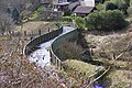
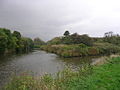
 Confluence of River Beal
 -
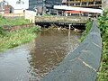 Flowing under one of the world's widest bridges
 -
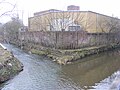
 Rochdale town centre section uncovered during bridge works
 -
 Confluence of River Spodden
 -
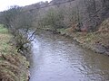 Upstream from Bottom o' th' Brow, Heywood
 -
 Confluence with River Irwell


