Llŷn

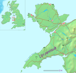
Llŷn or Lleyn is a peninsula of Caernarfonshire which extends 30 miles into the Irish Sea; a great jut of land the shape of an arm reaching out from north-western Wales. It is a place of timeless beauty of sea and land and is one of the strongholds of the Welsh language.
The name Llŷn is thought to be of Irish origin, and to have the same root (Laigin or Laighin in Irish language) as the name of Leinster. It formed a cantref up to King Edward's time, becoming then part of the new shire of Caernarfon.
Llŷn has a large number of protected sites, including a "National Nature Reserve" at Cors Geirch, a "National Heritage Coastline" and a "European Marine Special Area of Conservation", and 20 "Sites of Special Scientific Interest". The Llŷn Coastal Path, a long distance footpath, enables walkers to explore both coasts of the peninsula.

The Welsh Language and Heritage Centre of Nant Gwrtheyrn is found on the north coast. Much of the coastline and the volcanically formed hills are part of the Llŷn "Area of Outstanding Natural Beauty", confirming the peninsula as one of the most scientifically important in Britain. Though the volcanoes which formed the ancient hills are long since dead, in 1984 still there was an earthquake beneath the peninsula, which measured 5.4 on the Richter Scale and was felt in many parts of Ireland and western Britain.
Historically, the peninsula was used by pilgrims travelling to the Isle of Bardsey and the ancient inn at Aberdaron is still named the ‘’Y Gegin Fawr’’ after the big kitchen used to bake the pilgrims' supper before they set forth from the harbour over the treacherous sea to the island.
Welsh language
Llŷn’s relative isolation has helped to conserve the Welsh language and culture, for which the locality is now famous. This perceived remoteness from urban life has lent the area an unspoilt image which has made Llŷn a popular destination for both touring visitors and the owners of holiday home. Holiday homes remain a bone of contention among locals, many of whom are forced out of the housing market by incomers. From the 1970s to the 1990s, a shadowy group known as “Meibion Glyndŵr” claimed responsibility for several hundred arson attacks on holiday homes using incendiary devices. Some of these attacks took place in Llŷn.
Before 2001, there had been a decline in Welsh speakers in Caernarfonshire. According to the 2001 census the number of Welsh speakers in Wales increased for the first time in over 100 years, but the number of Welsh speakers declined in its heartland. Many who are concerned for the continuance of the language believe that that the influx of English speakers is damaging the standing of Welsh and threatening its future as a living community language in the area.
Tân yn Llŷn 1936
Concern for the Welsh language on Llŷn was ignited in 1936 when the United Kingdom government settled on establishing an aerial bombing school at Penyberth on the Peninsula. The events surrounding the protest became known as Tân yn Llŷn (Fire in Llŷn).[1] The government had settled on Llŷn as the site for its new bombing school after similar locations in Northumberland and Dorset were met with protests.[2] However, British Prime Minister Stanley Baldwin refused to hear the case against the bombing school in Wales, despite a deputation representing half a million Welsh protesters.
Protest against the bombing school was summed up by Saunders Lewis when he wrote that the British government was intent upon turning one of the "essential homes of Welsh culture, idiom, and literature" into a place for promoting a barbaric method of warfare. On 8 September 1936 the bombing school building was set on fire by Saunders Lewis, Lewis Valentine, and D J Williams, who immediately gave themselves up to the police and claimed responsibility. The trial at Caernarfon failed to agree on a verdict and the case was sent to the Old Bailey in London, where they were sentenced to nine months imprisonment in Wormwood Scrubs, and on their release they were greeted as heroes by 15,000 people at a pavilion in Caernarfon.[2] Three years later in 1939, the need for a bombing school became more apparent than in the pacifist days of the earlier 1930s.
Geography

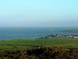
Llŷn is an extensive plateau dominated by numerous hills and mountains formed by ancient volcanoes. The largest of these is Yr Eifl, although Garn Boduan, Garn Fadrun and Mynydd Rhiw are also distinctive. Large stretches of the northern coast consist of steep cliffs and rugged rocks with offshore islands and stacks, while there are more extensive sandy beaches on the southern coast, such as Porth Neigwl and Castellmarch Beach. North of Abersoch a series of sand dunes has developed. The landscape is divided into a patchwork of fields, with the traditional field boundaries, stone walls, hedgerows and cloddiau, a prominent feature.
Bardsey Island is steeped in religion and holy traditions. The first monastery on the island was established before 542 AD, and it became a major centre of pilgrimage during mediæval times. There are numerous wells throughout the peninsula and to many some holy connotation was applied in the Middle Ages. They were important stops for pilgrims heading to the island.
The most rural parts are characterised by small houses, cottages and individual farms, resembling parts of south west Ireland. Small compact villages, built of traditional materials, are squeezed into the landscape. The only large scale industrial development was quarrying and mining, which has now largely ceased. The granite quarries of northern Llŷn have left a legacy of inclines and export docks, and were the reason for the growth of villages such as Llithfaen and Trefor. Copper, zinc and lead were mined around Llanengan, while 196,770 tons of manganese were produced at Y Rhiw between 1894 and 1945. Shipbuilding was important at Nefyn, Aberdaron, Abersoch and Llanaelhaearn, although the industry collapsed after the introduction of steel ships from 1880. Nefyn was also an important herring port, and crab and lobster fishing was carried out in most coastal communities.
Tourism developed after the construction of the railway to Pwllheli in 1867. The town expanded rapidly, with several large houses and hotels constructed, and a tramway was built linking the town to Llanbedrog. After the Second World War, Butlins established a holiday camp at Penychain, which attracted visitors from the industrial cities of South Lancashire and the Black Country. As car ownership increased, the tourist industry spread to the countryside and to coastal villages such as Aberdaron, Abersoch, Llanbedrog and Nefyn, where many families supplemented their income by letting out rooms and houses.[3]
The land and evocations of the land

There was that headland asleep on the sea
The air full of thunder and the far air
Brittle with lightning; there was that girl
Riding her cycle, hair at half-mast,
And the men smoking, the dinghies at rest
On the calm tide. There were people going
About their business, while the storm grew
Louder and nearer and did not break.
Farming was originally simple and what today would be described as "organic". Farming underwent major changes after Second World War as machines came into widespread use. Land was drained and fields expanded and reseeded. From the 1950s onwards, extensive use of modern methods led to great changes in the superficial appearance of the landscape.
R S Thomas served as vicar of Aberdaron from 1967 to 1978. A diligent and much loved clergyman and shepherd to his flock, if somewhat eccentric and outspoken, he was more famed as a poet, the author of many haunting or humour-laden poems of the Welsh countryside, many inspired by the landscape, villages and farmers of Lleyn.
Scarcely a street, too few houses
To merit the title; just a way between
The one tavern and the one shop
That leads nowhere and fails at the top
Of the short hill, eaten away
By long erosion of the green tide
Of grass creeping perpetually nearer
This last outpost of time past.[4]
Pwllheli has been the "capital" of Llŷn for over 700 years. It was a royal maerdref of the Kingdom of Gwynedd, and became a free borough following the English conquest. By the 1770s it was described as "the best town in this county", and in the 18th and 19th centuries over 400 ships were built there.[5]
Villages of Llŷn
|
|
|
Outside links
- Penllyn.com - Information sites for the communities of Llŷn
- Llyn.info - Your online guide to the Llŷn Peninsula
- Old postcard views and aerial views of the area
References
- ↑ John Davies, A History of Wales, Penguin, 1994, ISBN 0-14-014581-8, page 593
- ↑ 2.0 2.1 Davies, op cit, page 592
- ↑ Llŷn Area of Outstanding Natural Beauty : Management Plan : An Assessment of the Area and its Resources. Retrieved 14 January 2010.
- ↑ The Village by R S Thomas
- ↑ Gwynedd Archaeological Trust : Historic Landscapes : Pwllheli, Deneio and Penmaen. Retrieved 14 January 2010.


