Llandenny
| Llandenny | |
| Monmouthshire | |
|---|---|
 The Church of St John the Apostle and Evangelist | |
| Location | |
| Grid reference: | SO415035 |
| Location: | 51°43’38"N, 2°50’54"W |
| Data | |
| Population: | 316 |
| Post town: | Usk |
| Postcode: | NP15 |
| Dialling code: | 01291 |
| Local Government | |
| Council: | Monmouthshire |
| Parliamentary constituency: |
Monmouth |
Llandenny is a village and ancient parish in Monmouthshire, three miles south of Raglan and three miles north of Usk.[1] It forms part of the Raglan Hundred.
History and amenities
The little village of Llandenny is just a few houses, a pub (the Raglan Arms) and the Church of St John, named after St John the Apostle and Evangelist. The main south Wales to the Midlands road link, the A449, passes close to the village.
The Raglan Arms was promoted by Lord Raglan who owned, as the family still does, the large estate nearby. A landlord of the pub in the 1930s was Frank Wake who catered nearly always for the farm labourers and not the gentry so it became a 'thorn in the flesh' of the Raglan family.
The nearby Llandenny railway station building still exists though half demolished. It includes a ground frame signal box on the platform, a cattle dock and small goods sidings. It stood on the Coleford, Monmouth, Usk and Pontypool Railway line and closed in 1959.
-
 The Raglan Arms
 -
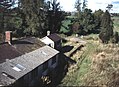 Disused railway station


Notes
- ↑ "Llanddenni / Llandenny, Monmouthshire". The National Gazetteer of Great Britain and Ireland. genuki.org.uk. 1868. http://www.genuki.org.uk/big/wal/MON/Llandenny/index.html. Retrieved 13 March 2012.
Outside links
| ("Wikimedia Commons" has material about Llandenny) |

This Monmouthshire article is a stub: help to improve Wikishire by building it up.