Haycock
| Haycock | |||
| Cumberland | |||
|---|---|---|---|
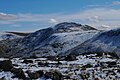
 The stony summit of Haycock (Scoat Fell and Steeple beyond) | |||
| Range: | Lake District Western Fells | ||
| Summit: | 2,614 feet; NY144107 54°29’4"N, 3°19’22"W | ||
Haycock is a mountain in Cumberland, in the western part of the Lake District. It rises to 2,614 feet between Scoat Fell and Caw Fell to the south of Ennerdale and the north of Wasdale. Haycock is an imposing dome shaped fell, its popularity with walkers diminished somewhat by its remoteness. It can be climbed from either valley and offers fine mountain views.
Landscape
The Western Fells of Lakeland occupy a triangular region, all in the bounds of Cumberland, bordered by the River Cocker to the north east and Wasdale to the south east. Westwards the hills diminish toward the coastal plain of Cumberland. At the central hub of the high country are Great Gable and its satellites, while two principal ridges fan out on either flank of Ennerdale, the western fells in effect being a great horseshoe around this long wild valley.[1] Haycock stands on the southern arm.
Little Gowder Crag is a subsidiary top on the fell, at NY140109 and itself 2,404 feet above sea level. It is found northwest of the main summit, on the ridge continuing to Caw Fell. Little Gowder Crag is listed as a 'Nuttall' hisll in its own right. It has its rock face to the north of the ridge, appearing as a prominent knuckle in views from that side.
The main watershed amongst hese hills runs broadly westwards from Great Gable, dividing the headwaters of Ennerdale and Wasdale. Travelling in this direction the major hills are Kirk Fell, Pillar, Scoat Fell, Haycock and Caw Fell. Haycock sends out a southern ridge to the neighbouring Seatallan.
The northern slopes of Haycock fall over crags into Great Cove, the birthplace of Deep Gill. This flows down through a belt of forestry into Ennerdale, just above the head of the lake. Great Cove is enclosed in the east by Tewit How, a rocky spur of neighbouring Scoat Fell. A similar spur closes in the other side, descending unnamed from Haycock.
Haycock's southern flanks are bisected by the ridge to Seatallan and Middle Fell. This begins steeply over Gowder Crag and then broadens over High Pikehow before finally reaching the depression at Pots of Ashness (1,640 feet). To the west is the head of the River Bleng, Haycock's daughter stream. This flows south west for some miles, remote from habitation. Finally it joins the River Irt and enters the sea at Ravenglass. On the opposite side of the south ridge is the valley of Nether Beck, making straight for Wast Water.
Geology
The summit area exhibits the plagioclase-phyric andesite lavas of the Birker Fell Formation. To the north are the siltstone, sandstone and tuff of the Eagle Crag Member, both containing andesite sills. Around High Pikehow are areas of Seatallan dacite.[2]
Summit
A wall, the Ennerdale Fence, runs along the watershed, crossing the top of the fell. There is a cairn on either side, that to the north being regarded as the nominal summit. The whole area is stony. Another cairn marks a viewpoint to the south.[1]
The view is good for a fell so removed from the centre of the District. The Scafells are seen in profile, with Helvellyn and Skiddaw in the distance. Ennerdale Water is in view from the summit and Wast Water from the southern cairn.[1]
Ascents
From Ennerdale the natural line follows the unnamed spur to the west of Deep Gill, footpaths having been created through the forestry. A longer route follows the opposing spur of Tewit How, turning right when the col is reached. Netherbeck Bridge provides access from the shore of Wast Water, following the stream around the base of Middle Fell. Once Ladcrag Beck is reached, a more direct line can be taken up Haycock. From below the lake, the valley of Greendale Beck provides another alternative. Haycock may also be ascended indirectly, having first climbed Seatallan, Middle Fell or Scoat Fell.[1][3]
Pictures
| ("Wikimedia Commons" has material about Haycock) |
-
 Haycock from Iron Crag
 -
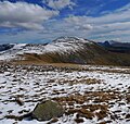 Haycock from Caw Fell


References
- ↑ 1.0 1.1 1.2 1.3 Wainwright, Alfred: A Pictorial Guide to the Lakeland Fells, Book Seven — The Western Fells (1966)
- ↑ British Geological Survey: 1:50,000 series maps, England & Wales Sheets 29 and 38: BGS (1999),(1998)
- ↑ Bill Birkett: Complete Lakeland Fells: Collins Willow (1994):ISBN 0-00-713629-3