East Cottingwith
Jump to navigation
Jump to search
| East Cottingwith | |
| Yorkshire East Riding | |
|---|---|
 St Mary's Church | |
| Location | |
| Grid reference: | SE703423 |
| Location: | 53°52’21"N, -0°55’52"W |
| Data | |
| Population: | 349 (2011) |
| Post town: | York |
| Postcode: | YO42 |
| Dialling code: | 01759 |
| Local Government | |
| Council: | East Riding of Yorkshire |
| Parliamentary constituency: |
East Yorkshire |
East Cottingwith is a village in the East Riding of Yorkshire. It stands by the former Derwent Navigation canal, nine miles north-west of the market town of Howden and seven miles south-west of Pocklington. York is to the north-west. The village is just to the east of the River Derwent.
The village church is St Mary's and is a Grade II listed building.[1]
Pictures
| ("Wikimedia Commons" has material about East Cottingwith) |
-
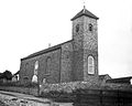 St Mary's Church, 1900–1912
 -
 The village street, 1900–1912
 -
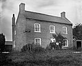 Ferry Boat Inn, 1900–1912
 -
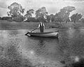
 Narrowboat at Cottingwith Lock, near East Cottingwith
 -
 View of the river near East Cottingwith, 1900–1912


Outside links
- East Cottingwith in the Domesday Book
References
- ↑ National Heritage List 1309872: Church of St Mary (Grade II listing)
- Gazetteer — A–Z of Towns Villages and Hamlets. East Riding of Yorkshire Council. 2006. p. 5.