Cusher River

Cusher River is a river in County Armagh. It is formed by the junction, near Mountnorris, of two small streams (the Creggan and the Blackwater), flows by Tandragee, and joins the River Bann one mile above Portadown.[1]
A short distance south of Portadown is the start of the Newry Canal inland navigation. Here the canal is between two rivers: the Cusher River and the Upper River Bann. The Cusher River supplemented water to the lower part of the system.[2] The Point of Whitecoat is where three waterways meet: the Bann, the Cusher River and the Newry Canal, the first inland canal in the British Isles.[3]
History
In the 19th century there were many flax mills, as well as mills for flour, oats and cornmeal on the Cusher River in the Tandragee area.[4]
Pollution
In June 2008, at Tandragee, hundreds of trout and roach died after pollution was released into the Cusher River[5]
Pictures
| ("Wikimedia Commons" has material about Cusher River) |
-
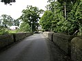 Bridge over the River Cusher at Clare
 -
 Cusher River at Loughgilly
 -
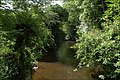 The Cusher in Clare Glen


References
- ↑ "Armagh - Atlas and Cyclopedia of Ireland (1900)". Library Ireland. http://www.libraryireland.com/Atlas/Armagh.php. Retrieved 27 February 2009.
- ↑ "The Newry Canal from Portadown to Newry". Inland Waterways Association of Ireland - Waterways Heritage. http://heritage.iwai.ie/waterways/newry_canal1.shtml. Retrieved 27 February 2009.
- ↑ "The Craigavon Trail". Discover Northern Ireland. http://www.discovernorthernireland.com/The-Craigavon-Trail-Craigavon-P2134. Retrieved 27 February 2009.
- ↑ "The Davisons from Tandragee". Davisons website. http://history.davison.ca/. Retrieved 27 February 2009.
- ↑ "Five years of fish kills and the causes behind them". Belfast Telegraph - 18 July 2008. http://www.belfasttelegraph.co.uk/news/local-national/five-years-of-fish-kills-and-the-causes-behind-them-13912448.html. Retrieved 27 February 2009.
Coordinates: 54°23′N 6°24′W / 54.383°N 6.4°W