Clifton, Derbyshire
| Clifton | |
| Derbyshire | |
|---|---|
 Clifton | |
| Location | |
| Grid reference: | SK165448 |
| Location: | 53°0’4"N, 1°45’14"W |
| Data | |
| Population: | 500 (2011) |
| Post town: | Ashbourne |
| Postcode: | DE6 |
| Local Government | |
| Council: | Derbyshire Dales |
Clifton is a village in Derbyshire, sitting just over a mile south-west of Ashbourne, and close to the border with Staffordshire.
History and notable buildings
Margery Bower is a round barrow assumed to date from the Bronze Age.[1] It lies on the southern side of the village on the road to Snelston.
Clifton Hall was built in the late 18th century, altered in the 19th and 20th centuries.[2] It stands close to the centre of the village on Chapel Lane.
Holy Trinity church was designed by Henry Isaac Stevens of Derby, and built in 1845.[3] Opposite the church stands the Cock Inn public house.
The village formerly had a railway station, opened in 1852 as Clifton and renamed in 1893 as Clifton (Mayfield), on a branch of the North Staffordshire Railway between Rocester and Ashbourne.[4] Passenger services ended in 1954 with the line closing for freight services in 1964.
Sport and recreation
- Clifton recreation ground
- Clifton Cricket club
- Ashbourne Golf Course
At the site of the old corn mill lies a stone which acts as the Down'ards goal in the annual traditional Royal Shrovetide Football match. There are two adjacent stone markers, the old and the new.
Pictures
| ("Wikimedia Commons" has material about Clifton, Derbyshire) |
-
 Clifton Church
 -
 Clifton recreation ground
 -
 Ashbourne Golf Course, near Clifton
 -
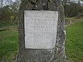 Plaque on the Clifton Goal
 -
 The "New" Clifton Goal


References
- ↑ Gill Stroud (2001), Derbyshire Extensive Urban Survey - Architectural Assessment Report - Ashbourne
- ↑ National Heritage List 1158395: Clifton Hall and attached wall and railings (Grade II listing)
- ↑ National Heritage List 1158352: Church of the Holy Trinity (Grade II listing)
- ↑ Butt, R.V.J. (1995). The Directory of Railway Stations. Yeovil: Patrick Stephens Ltd. p. 63. R508. ISBN 1-85260-508-1.