Thornton Watlass
| Thornton Watlass | |
| Yorkshire North Riding | |
|---|---|
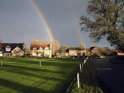
 Thornton Watlass village green | |
| Location | |
| Grid reference: | SE235855 |
| Location: | 54°15’54"N, 1°38’18"W |
| Data | |
| Population: | 240 (2016 est.) |
| Post town: | Ripon |
| Postcode: | HG4 |
| Dialling code: | 01677 |
| Local Government | |
| Council: | North Yorkshire |
Thornton Watlass is a small village in the North Riding of Yorkshire, to the north of Masham and south of Bedale on the eastern slopes of the vaslley of the River Ure at the entrance to Wensleydale and of the Yorkshire Dales National Park.[1] It is eleven miles north of Ripon, four miles from the A1(M) motorway, and eleven miles from the main railway line at Northallerton. Its population was recorded as 224 in 2011.
The village stands at the junction of Watlass Lane and Watlass Moor Lane. At the centre of the village is the triangular village green with its trees, cricket pitch and children's playground, surrounded by houses, some of which are built from local stone. Thornton Watlass Church dates from the 11th century and the village also has a primary school and a public house called the Buck Inn. The village forms part of the Thornton Watlass Estate, and Thornton Watlass Hall, an ancient two-storey gabled stone house, lies just to the north of the village.
History
A prehistoric feature in the Thornton Watlass area is Gospel Hill tumulus, a Scheduled Ancient Monument, at SE228862 about half a mile north-west of the village. The site of the priory is now a scheduled ancient monument.[2]
Anglo-Saxon remains of two cross-heads are evidence that people lived in the area before the Norman Conquest in 1066. They are on display in Thornton Watlass Church.
The Domesday Book of 1086 mentions the separate villages of Thornton and Watlass.[3] Before the Norman conquest the Saxon owners of these villages were Ulward and Stan; however Thornton is shown in the Domesday Book as being owned by Ribald, brother of Alan Earl of Richmond. Thornton Watlass Hall and estate have been owned by the Dodsworth family since 1415.
The parish church, St Mary the Virgin stands a little way outside the village to the south-west. It was rebuilt, with the exception of the tower, in 1868 in the Perpendicular style.[4] The tower contains some living accommodation (including a toilet) and was probably used as a place of safety in times of strife.
The village school was built in 1872.[4]
Outside links
| ("Wikimedia Commons" has material about Thornton Watlass) |
References
- ↑ Cally (2007). "Buck Inn". A1 Tourism. http://www.a1tourism.com/uk/buckinn.html. Retrieved 15 April 2007.
- ↑ National Heritage List 1018922: Round barrow known as Gospel Hill, south west of Pasture House (Scheduled ancient monument entry)
- ↑ Sir John Smith-Dodsworth, Bt (1987). "History". Thornton Watlass Hall. Archived from the original on 6 March 2005. https://web.archive.org/web/20050306234650/http://www.dodsworth.demon.co.uk/history.html. Retrieved 15 April 2007.
- ↑ 4.0 4.1 Colin Hinson (2007). "Thornton Watlass: Geographical and Historical information from the year 1890, from Bulmer's History and Directory of North Yorkshire (1890)". GENUKI. http://www.genuki.org.uk/big/eng/YKS/NRY/Thorntonwatlass/Thorntonwatlass90.html. Retrieved 16 April 2007.
