Difference between revisions of "Tay Bridge, Aberfeldy"
(Created page with "{{Infobox bridge |county=Perth |name=Wade's Bridge |picture=Wade's Bridge Aberfeldy.jpg |picture caption=The bridge in 2022 |crosses=River Tay |town=Aberfeldy |architect=Willi...") |
(No difference)
|
Revision as of 10:13, 28 June 2023
| Wade's Bridge | |
| Perthshire | |
|---|---|
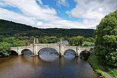
 The bridge in 2022 | |
| Location | |
| Crossing: | River Tay |
| Location | |
| Location: | 56°37’17"N, 3°52’25"W |
| Structure | |
| Length: | 367 ft |
| History | |
| Built 1733 | |
| Architect: | William Adam |
| Information | |
The Tay Bridge or Wade's Bridge is five-arch bridge crossing the River Tay at Aberfeldy, Perthshire. A Category A listed structure built in 1733,[1] to a design by William Adam, it carries the pedestrian and vehicle traffic of Poplar Avenue.[2] Erected for the Board of Ordnance, to the order of Lieutenant General George Wade, its original purpose was as a military road linking the garrisons at Ruthven, Fort George, Fort Augustus and Fort William.[3]
The stone was quarried, cut and tooled at nearby Bolfracks. In 1932, two tablets with copies of Wade's original inscriptions were let into the stonework of two obelisk plinths; one in English and one in Latin. These state that the bridge was begun in April 1733 and finished by January; however, this is not strictly true, as General Wade stopped work for the winter, leaving the bridge without parapets over the side arches. These were added the following year.[2]
References
- ↑ Ordnance Gazetteer of Scotland: A Graphic and Accurate Description of Every Place in Scotland, Francis Hindes Groome (1901)
- ↑ 2.0 2.1 Tay Bridge – Historic Environment Scotland
- ↑ Mackenzie, Sir Kenneth (13 April 1897). Paper entitled General Wade & his Roads. Inverness Scientific Society.
Outside links
- General Wade's Roads – Historic Environment Scotland
- Aberfeldy Conservation Area Appraisal – Perth and Kinross Council, November 2008
This Perthshire article is a stub: help to improve Wikishire by building it up.