Difference between revisions of "Cwmdu, Brecknockshire"
m (Owain moved page Cwmdu to Cwmdu, Brecknockshire) |
|||
| Line 1: | Line 1: | ||
| − | [[Image:View of Cwmdu, Powys from Cwmdu Caravan and Camping Site.JPG|thumb|300px|A picture of Cwmdu | + | {{county|Brecon}} |
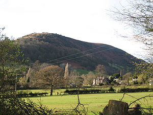
| − | '''Cwmdu''' or '''Llanfihangel Cwmdu''' is a small village situated in the heart of the [[Black Mountains]] in [[Brecknockshire]]. Its name is derived from the Welsh language "Cwm Du", which means 'Black Valley'. It is located on the A479 [[Talgarth]] to Tretower road. | + | [[Image:View of Cwmdu, Powys from Cwmdu Caravan and Camping Site.JPG|thumb|300px|A picture of Cwmdu from the campsite. In the picture you can see the school and the church]] |
| + | '''Cwmdu''' or '''Llanfihangel Cwmdu''' is a small village and ancient parish situated in the heart of the [[Black Mountains]] in [[Brecknockshire]]. Its name is derived from the Welsh language "Cwm Du", which means 'Black Valley'. It is located on the A479 [[Talgarth]] to Tretower road. | ||
== Amenities == | == Amenities == | ||
| Line 19: | Line 20: | ||
==Outside links== | ==Outside links== | ||
| + | *Location map: {{wmap|51.90389|-3.19361|zoom=14}} | ||
*[http://www.maplandia.com/united-kingdom/wales/wales/powys/cwm-du/ Satellite map at Maplandia] | *[http://www.maplandia.com/united-kingdom/wales/wales/powys/cwm-du/ Satellite map at Maplandia] | ||
*[http://www.breconcottages.com/index.cfm/areas/cwmdu Description of the Cwmdu area from a local tourist website] | *[http://www.breconcottages.com/index.cfm/areas/cwmdu Description of the Cwmdu area from a local tourist website] | ||
| Line 24: | Line 26: | ||
*[http://www.megalithic.co.uk/article.php?sid=15268 The prehistory and history of the locality] | *[http://www.megalithic.co.uk/article.php?sid=15268 The prehistory and history of the locality] | ||
| − | |||
[[Category:Towns and villages in Brecknockshire]] | [[Category:Towns and villages in Brecknockshire]] | ||
| − | |||
{{stub}} | {{stub}} | ||
Latest revision as of 11:39, 26 May 2019
Cwmdu or Llanfihangel Cwmdu is a small village and ancient parish situated in the heart of the Black Mountains in Brecknockshire. Its name is derived from the Welsh language "Cwm Du", which means 'Black Valley'. It is located on the A479 Talgarth to Tretower road.
Amenities
Cwmdu has several public facilities, including a park, a garage, a campsite,[1] a village pub, the Farmers Arms [1] and a cafe, the Mynydd-Ddu Tea Room.
Its primary school, which opened in 1873 and was visited by Prince Charles in 2006, closed in 2012.
Cwmdu attracts many tourists every year, who mainly consist of hikers hillwalking through on the Beacons Way [2]. Cwmdu is an attractive hiking destination as it is situated in the heart of the Black Mountains, and is only about 12 miles away from the Brecon Beacons; the highest mountain range in South Wales and within the region's National Park.
The Church of the Archangel Michael is a grade II* listed building, largely rebuilt in 1830. [2]
Nearby towns include Crickhowell; a small market town which is famous for its beautiful 16th century river bridge across the River Usk and a range of quaint shops. Abergavenny is also found nearby over the border with Monmouthshire; a larger market town than Crickhowell, it is also popular with ramblers because of its 'Three Peaks'; the Sugar Loaf, the Blorenge and the Skirrid.
In 2012 Cwmdu was selected as the site for the bi-annual AstroCamp, the first of which took place on the weekend of September 7-9, 2012. This saw a large gathering of astronomers at the campsite and Farmers Arms Pub and was televised by the BBC The Sky at Night programme the following October.[3]
References
Outside links
- Location map: 51°54’14"N, 3°11’37"W
- Satellite map at Maplandia
- Description of the Cwmdu area from a local tourist website
- Cwmdu on Genuki website
- The prehistory and history of the locality
This Brecknockshire article is a stub: help to improve Wikishire by building it up.
