Difference between revisions of "Crichton"
m |
|||
| Line 1: | Line 1: | ||
{{county|Midlothian}} | {{county|Midlothian}} | ||
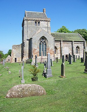
[[File:Crichton Collegiate Church - geograph.org.uk - 827148.jpg|thumb|right|300px|Crichton Collegiate Church]] | [[File:Crichton Collegiate Church - geograph.org.uk - 827148.jpg|thumb|right|300px|Crichton Collegiate Church]] | ||
| − | '''Crichton''' is a parish on the eastern border of [[Midlothian]] on the A68 road from [[Edinburgh]] to [[Lauder]], five miles south-east of [[Dalkeith]]. The parish contains, at its northern extremity, the village of [[Pathhead, Midlothian|Pathhead]]. Tynehead and Fala Dam hamlet (2¾ miles south-east of Pathhead) also belong to Crichton, which is bounded to the north-east by [[Cranston]] and by [[Humbie]] in [[East Lothian]]; south-east by [[Fala and Soutra]] and | + | '''Crichton''' is a village and parish on the eastern border of [[Midlothian]] on the A68 road from [[Edinburgh]] to [[Lauder]], five miles south-east of [[Dalkeith]]. The parish contains, at its northern extremity, the village of [[Pathhead, Midlothian|Pathhead]]. Tynehead and Fala Dam hamlet (2¾ miles south-east of Pathhead) also belong to Crichton, which is bounded to the north-east by [[Cranston]] and by [[Humbie]] in [[East Lothian]]; south-east by [[Fala and Soutra]] and [[Heriot]]; and west by [[Borthwick]]. The village itself is located to the south of Pathhead on the B6367 road. |
| + | |||
| + | The rising ground at Longfough, commanding a wide and beautiful prospect, is crowned by remains of a fort, supposed to be a Roman camp; but Crichton's chief antiquities are [[Crichton Castle]] and [[Cakemuir Castle]], the former a massive ruin, forming the grand feature in the landscape. | ||
| + | |||
| + | ==Outside links== | ||
| + | *Location map: {{wmap|55.84731|-2.98683|zoom=14}} | ||
| − | |||
[[Category:Towns and villages in Midlothian]] | [[Category:Towns and villages in Midlothian]] | ||
{{stub}} | {{stub}} | ||
Latest revision as of 19:06, 3 November 2016
Crichton is a village and parish on the eastern border of Midlothian on the A68 road from Edinburgh to Lauder, five miles south-east of Dalkeith. The parish contains, at its northern extremity, the village of Pathhead. Tynehead and Fala Dam hamlet (2¾ miles south-east of Pathhead) also belong to Crichton, which is bounded to the north-east by Cranston and by Humbie in East Lothian; south-east by Fala and Soutra and Heriot; and west by Borthwick. The village itself is located to the south of Pathhead on the B6367 road.
The rising ground at Longfough, commanding a wide and beautiful prospect, is crowned by remains of a fort, supposed to be a Roman camp; but Crichton's chief antiquities are Crichton Castle and Cakemuir Castle, the former a massive ruin, forming the grand feature in the landscape.
Outside links
- Location map: 55°50’50"N, 2°59’13"W
This Midlothian article is a stub: help to improve Wikishire by building it up.
