Difference between revisions of "Arbury Hill"
(Created page with '{{Infobox hill |name=Arbury Hill |county=Northamptonshire |picture=Arbury Hill, Northamptonshire 17th April 2008 (1).JPG |picture caption=Arbury Hill from the west |height=738 fe…') |
|||
| Line 5: | Line 5: | ||
|picture caption=Arbury Hill from the west | |picture caption=Arbury Hill from the west | ||
|height=738 feet | |height=738 feet | ||
| − | |os grid ref=SP5401558770 | + | |os grid ref=SP5401558770 |
| + | |latitude=52.224495 | ||
| + | |longitude=-1.210663 | ||
}} | }} | ||
| − | '''Arbury Hill''' in [[Northamptonshire]] is a distinctly shaped hill found 5½ miles | + | '''Arbury Hill''' in [[Northamptonshire]] is a distinctly shaped hill found 5½ miles south-west of [[Daventry]]. At 738 feet, Arbury Hill’s summit is the [[County top|highest point]] in Northamptonshire. |
The hill is part of a three-way watershed. Northamptonshire has the remarkable distinction that no river nor stream however small enters the county from elsewhere, though it is the source of several rivers issuing from the county. On the slopes of Arbury Hill are the sources of: | The hill is part of a three-way watershed. Northamptonshire has the remarkable distinction that no river nor stream however small enters the county from elsewhere, though it is the source of several rivers issuing from the county. On the slopes of Arbury Hill are the sources of: | ||
| − | *The [[River Nene]], which flows | + | *The [[River Nene]], which flows north-west and ultimately to [[the Wash]]; |
*The [[River Leam]] (from the Leam Pool, [[Hellidon]]) flowing west to the [[River Avon, Warwickshire|Warwickshire Avon]] and whose waters ultimately reach the [[River Severn|Severn Estuary]] and the Atlantic; and | *The [[River Leam]] (from the Leam Pool, [[Hellidon]]) flowing west to the [[River Avon, Warwickshire|Warwickshire Avon]] and whose waters ultimately reach the [[River Severn|Severn Estuary]] and the Atlantic; and | ||
*The [[River Cherwell]] flowing due south to the [[River Thames|Thames]] at [[Oxford]], its waters taken thence to the [[North Sea]]. | *The [[River Cherwell]] flowing due south to the [[River Thames|Thames]] at [[Oxford]], its waters taken thence to the [[North Sea]]. | ||
| Line 21: | Line 23: | ||
==Pictures== | ==Pictures== | ||
<gallery> | <gallery> | ||
| − | File:Headwater of the River Nene near Arbury Hill 17th April 2008 (1).JPG|The headwater of the Nene, on the north east slope of Arbury Hill | + | File:Headwater of the River Nene near Arbury Hill 17th April 2008 (1).JPG|The headwater of the Nene, on the north-east slope of Arbury Hill |
File:Arbury Hill from the south 17th April 2008 (1).JPG|The southern side of the Hill | File:Arbury Hill from the south 17th April 2008 (1).JPG|The southern side of the Hill | ||
</gallery> | </gallery> | ||
Revision as of 17:04, 9 March 2018
| Arbury Hill | |
| Northamptonshire | |
|---|---|
.JPG) Arbury Hill from the west | |
| Summit: | 738 feet SP5401558770 52°13’28"N, 1°12’38"W |
Arbury Hill in Northamptonshire is a distinctly shaped hill found 5½ miles south-west of Daventry. At 738 feet, Arbury Hill’s summit is the highest point in Northamptonshire.
The hill is part of a three-way watershed. Northamptonshire has the remarkable distinction that no river nor stream however small enters the county from elsewhere, though it is the source of several rivers issuing from the county. On the slopes of Arbury Hill are the sources of:
- The River Nene, which flows north-west and ultimately to the Wash;
- The River Leam (from the Leam Pool, Hellidon) flowing west to the Warwickshire Avon and whose waters ultimately reach the Severn Estuary and the Atlantic; and
- The River Cherwell flowing due south to the Thames at Oxford, its waters taken thence to the North Sea.
The hill is privately owned and not generally accessible.
Earthworks
On the summit of Arbury Hill there are the vestiges of an fortification, which is usually identified as an Iron Age Fort although this was disputed by the Royal Commission in 1981. The remains are in the form of a square ditch and embankment about 200 yards across; rather an unusual formation for an Iron Age fort.
Pictures
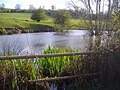
The headwater of the Nene, on the north-east slope of Arbury Hill
The southern side of the Hill
.JPG)
.JPG)