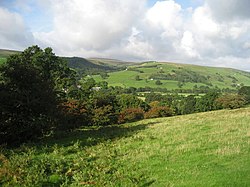
Bouthwaite
| Bouthwaite | |
| Yorkshire West Riding | |
|---|---|
 Upper Nidderdale near Bouthwaite | |
| Location | |
| Grid reference: | SE123712 |
| Location: | 54°8’13"N, 1°48’46"W |
| Data | |
| Post town: | Harrogate |
| Postcode: | HG3 |
| Local Government | |
| Council: | Harrogate |
Bouthwaite is a tiny hamlet in the West Riding of Yorkshire, sitting in Nidderdale, at the edge of the Pennines, to the north of Pateley Bridge and close to the village of Ramsgill.
The Nidderdale Way and Six Dales Trail both pass through the hamlet.
The place is first mentioned in 1184 as Burtheit. The name means "cottage or store-house clearing", from the Old Norse búr þveit.[1] Fountains Abbey owned the land in the Middle Ages and established a grange at Bouthwaite.[2]
Between 1907 and 1930 Bouthwaite was the site of Ramsgill railway station on the Nidd Valley Light Railway.[3]
Outside links
| ("Wikimedia Commons" has material about Bouthwaite) |
References
- ↑ Smith, A. H. (1961). The Place-names of the West Riding of Yorkshire. 5. Cambridge University Press. p. 202.
- ↑ Jennings, Bernard (1992). A History of Nidderdale. p. 88. ISBN 1-85072-114-9.
- ↑ Suggitt, Gordon (2010) [2005]. Lost Railways of North & East Yorkshire. Newbury, Berkshire: Countryside Books. ISBN 9781853069185.
