Belchalwell
| Belchalwell | |
| Dorset | |
|---|---|
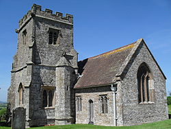
 St Aldhelm's Church, Belchalwell | |
| Location | |
| Grid reference: | ST791097 |
| Location: | 50°53’12"N, 2°17’55"W |
| Data | |
| Local Government | |
| Council: | Dorset |
| Parliamentary constituency: |
North Dorset |
Belchalwell is a small village by Okeford Fitzpaine in the Blackmore Vale of northern Dorset. The village is to be found two and a half miles south of Sturminster Newton and six miles north-west of Blandford Forum.
The village is sited on greensand.[1] beneath the north slopes of Bell Hill, part of the Dorset Downs.
Belchalwell is of Saxon origin, with a mediæval church, St Aldhelm's Church, much renovated.
The name of the village describes a cold well on a hillside.[2] The village has approximately 30 properties with fewer than a hundred residents, and is much reduced in size from former times, largely due to reductions in agricultural employment, which has always been the primary industry.
Outside links
| ("Wikimedia Commons" has material about Belchalwell) |
- https://www.okeford-fitzpaine.org/parish-information/belchalwell-village/ Okeford Fitzpaine Parish Council: Belchalwell]
- Information on Belchalwell from GENUKI
References
- ↑ Ralph Wightman (1983). Portrait of Dorset (4 ed.). Robert Hale Ltd. p. 16. ISBN 0-7090-0844-9.
- ↑ Roland Gant (1980). Dorset Villages. Robert Hale Ltd. p. 81. ISBN 0-7091-8135-3.
