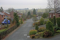
Thorpe, Westmorland
| Thorpe | |
| Westmorland | |
|---|---|
 Thorpe Field | |
| Location | |
| Grid reference: | NY499266 |
| Location: | 54°37’57"N, 2°46’39"W |
| Data | |
| Post town: | Penrith |
| Postcode: | CA10 |
| Dialling code: | 01768 |
| Local Government | |
| Council: | Westmorland & Furness |
| Parliamentary constituency: |
Penrith and The Border |
Thorpe is a hamlet in northern Westmorland, adjoining Sockbridge, which is on the south bank of the River Eamont, forming here the border with Cumberland. The closest town is Penrith in the latter county, two and a half miles to the north-north-east.
The two hamlets of Thorpe and Tirril have grown together with Sockbridge so that they are in effect one with the latter village. Thorpe stands to the west, barely distinguishable today.