Wells
| Wells | |
| Somerset | |
|---|---|
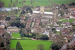 Wells from the air | |
| Location | |
| Grid reference: | ST545455 |
| Location: | 51°12’26"N, 2°39’7"W |
| Data | |
| Population: | 10,406 (2001) |
| Post town: | Wells |
| Postcode: | BA5 |
| Dialling code: | 01749 |
| Local Government | |
| Council: | Mendip |
| Parliamentary constituency: |
Wells |
Wells is a cathedral city in Somerset, on the southern edge of the Mendip Hills. Though the town has but 10,000 souls or thereabouts, it is a city and has held that status since 1205; one of the smallest cities in Britain.
The name Wells derives from the three wells dedicated to St Andrew, one in the market place and two within the grounds of the Bishop's Palace and cathedral.[1] There was a small Roman settlement around the wells, but its importance grew after King Ine of Wessex founded a minster church in 704, around which the settlement grew. Wells became a trading centre and involved in cloth making before its involvement in both the English Civil War and the Monmouth Rebellion during the 17th century. In the 19th century, transport infrastructure improved with stations on three different railway lines.
The cathedral and the associated religious and architectural history have made Wells a tourist destination, which provides much of the employment. The city has a variety of sporting and cultural activities and houses several schools including The Blue School, a state coeducational comprehensive school originally founded in 1654 and the independent Wells Cathedral School, which was founded in 909 and is one of the five established musical schools for school-age children in Britain. The historic architecture of the city has also been used as a location for several films and television programmes.
The lie of the land
Wells lies at the foot of the southern escarpment of the Mendip Hills where they meet the Somerset Levels. The hills are largely made of carboniferous limestone, which is quarried at several nearby sites. In the 1960s, the tallest mast in the region, the Mendip UHF television transmitter, was installed on Pen Hill above Wells, reaching even higher at its tip that Somerset’s county top, Dunkery Beacon.
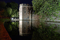
The water from the springs fills the moat around the Bishops Place and then flows into Keward Brook, which carries it for approximately a mile west to the point where the brook joins the River Sheppey in the village of Coxley.[2]
Churches
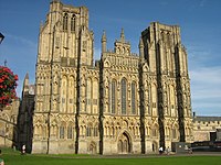
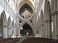
Wells Cathedral
Wells Cathedral is the seat of the Diocese of Bath and Wells. A walled precinct, the Liberty of St Andrew, encloses the twelfth century Cathedral, the Bishop's Palace, Vicar's Close and the residences of the clergy who serve the cathedral. Entrances include the Penniless Porch[3] The Bishop's Eye[4] and Brown's Gatehouse[5] which were all built around 1450.
Wells has been an ecclesiastical city of importance for hundreds of years. Parts of the building date back to the tenth century, and it is a Grade I listed building.[6] It is known for its fine fan vaulted ceilings, Lady Chapel and windows, and the scissor arches which support the central tower. The west front is said to be the finest collection of statuary in Europe,[7] retaining almost 300 of its original mediæval statues,[8] carved from the cathedral's warm, yellow Doulting stone.[9]
The Chapter House, at the top of a flight of stone stairs, leading out from the north transept is an octagonal building with a fan-vaulted ceiling.[10] It is here that the business of running the cathedral is still conducted by the members of the Chapter, the cathedral's ruling body. Wells Cathedral clock is famous for its 24-hour astronomical dial and set of jousting knights that perform every quarter hour.
The cathedral has the heaviest ring of ten bells in the world. The tenor bell weighs just over 56 cwt (6,272 lb).[11]
The Bishop's Palace has been the home of the Bishops of Bath and Wells for 800 years. The hall and chapel date from the 14th century.[12] There are 14 acres of gardens including the springs from which the city takes its name. Visitors can also see the Bishop's private chapel, ruined great hall and the gatehouse with portcullis and drawbridge beside which mute swans ring a bell for food.[13] The Bishop's Barn was built in the 15th century.[14]
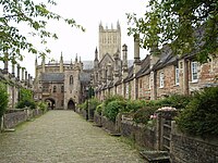
The Vicars' Close is the oldest residential street in Europe.[15] The Close is tapered by 10 feet to make it look longer when viewed from the bottom. When viewed from the top, however, it looks shorter.[16][17][18][19][20][21]
The Old Deanery dates from the 12th century,[22][23][24] and St John's Priory from the 14th.[25]
St Cuthbert's
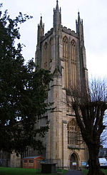
The Church of St Cuthbert (which tourists often reportedly mistake for the cathedral) has a fine Somerset stone tower and a superb carved roof. Originally an Early English building (13th century), it was much altered in the Perpendicular period (15th century).[15] The nave's coloured ceiling was repainted in 1963 at the instigation of the then Vicar's wife, Mrs Barnett.[26][27] Until 1561 the church had a central tower which either collapsed or was removed, and has been replaced with the current tower over the west door.[28] Bells were cast for the tower by Roger Purdy.[29]
History
The city was a Roman settlement but only became an important centre when King Ine of Wessex founded a minster church in 704.[30] Two hundred years later, this became the seat of the local bishop; but in 1088, this had been removed to Bath.[31] This caused severe arguments between the canons of Wells and the monks of Bath until the bishopric was renamed "Bath and Wells", to be elected by both religious houses. Wells became a borough some time before 1160 when Bishop Robert granted its first charter. Fairs were granted to the City before 1160.[31]
Wells was listed in the Domesday Book of 1086 as Welle.[32] which was not listed as a town, but included four manors with a population of 132, which implies a population of 500–600.[33]
An established market had been created in Wells by 1136, and it remained under episcopal control until its city charter from Elizabeth I in 1589.[33]
During the English Civil War, Parliamentarian troops used the cathedral to stable their horses and damaged much of the ornate sculpture by using it for firing practice.[34] William Penn stayed in Wells shortly before leaving for America, spending a night at The Crown Inn. Here he was briefly arrested for addressing a large crowd in the market place, but released on the intervention of the Bishop of Bath and Wells.[35]
During the Monmouth Rebellion the rebel army attacked the cathedral in an outburst against the established church and damaged the west front. Lead from the roof was used to make bullets, windows were broken, the organ smashed and horses stabled in the nave.[36] Wells was the final location of the Bloody Assizes on September 23, 1685. In a makeshift court lasting only one day, over 500 men were tried and the majority sentenced to death.[37]
There was a port at Bleadney on the River Axe in the 8th century that enabled goods to be brought to within 3 miles of Wells. In the Middle Ages overseas trade was carried out from the port of Rackley. In the 14th century a French ship sailed up the river and by 1388 Thomas Tanner from Wells used Rackley to export cloth and corn to Portugal, and received iron and salt in exchange.[38] Wells had been a centre for cloth making, however in the 16th and 17th centuries this diminished, but the town retained its important market focus.[39]
Wells has had three railway stations: Priory Road opened in 1859 on the Somerset Central Railway (later the Somerset and Dorset Joint Railway), one on the East Somerset Railway, and Tucker Street on the Cheddar Valley line branch of the Bristol and Exeter Railway from Yatton. In 1878 the East Somerset station closed. Priory Road closed to passenger traffic in 1951 but remained the city's main goods depot until closed in 1963 under the Beeching Axe.
During Second World War, Stoberry Park in Wells was the location of a Prisoner of War camp, housing Italian prisoners from the Western Desert Campaign, and later German prisoners after the Battle of Normandy. Penleigh Camp on the Wookey Hole Road was a German working camp.[40]
City status had been enjoyed for many centuries but at the abolition of the old borough on 1 April 1974 it was confirmed and formalised by Queen Elizabeth II by letters patent issued under the Great Seal.[41][15]
In books, film and television
- City of Bells by Elizabeth Goudge fictionalises Wells as the cathedral city of Torminster.
- The Canterbury Tales (1973)
- A Fistful of Fingers (1994)
- The Gathering (2002)
- The Libertine (2005)
- The Golden Age (2007)
- Hot Fuzz (2007)
The cathedral interior stood in for Southwark Cathedral during filming for the Doctor Who episode The Lazarus Experiment.
Outside links
| ("Wikimedia Commons" has material about Wells) |
References
- ↑ "The Well House". Images of England. http://www.imagesofengland.org.uk/details/default.aspx?id=483263. Retrieved 24 August 2006.
- ↑ "Nutricia, Glastonbury Rd Wells, Draionage Infrastructure Report". Robert West Consulting. 2008. pp. 6–7. http://www.mendip.gov.uk/pods/documents/documents%5C076028_032%5Cforms%5C076028_032_Drainage%20Infrastructure%20Report.pdf. Retrieved 16 March 2010.
- ↑ Images of England — details from listed building database (483442) Penniless Porch Gateway to Cathedral Green, Wells
- ↑ Images of England — details from listed building database (483444) The Bishop's Eye, Wells
- ↑ Images of England — details from listed building database (483519) Brown's Gatehouse, Wells
- ↑ Images of England — details from listed building database (483287) Cathedral Church of St Andrew, Chapter House and Cloisters
- ↑ "Stop 5: Wells, Somerset". Britannia's Magical History Tour. Britania Travels. http://www.britannia.com/travel/magical/magic6.html. Retrieved 4 February 2010.
- ↑ "The West Front". Wells Cathedral. http://www.wellscathedral.org.uk/history/architecture/westfront.shtml. Retrieved 4 February 2010.
- ↑ Ashurst, John & Dimes, Francis G: "Conservation of building and decorative stone", 1998
- ↑ Images of England — details from listed building database (483286) Chapter House to Cathedral Church of St Andrew
- ↑ "Bells". Wells Cathedral. http://www.wellscathedral.org.uk/worship/bells.shtml. Retrieved 4 August 2008.
- ↑ Images of England — details from listed building database (483259) The Bishop's Palace and Bishop's House
- ↑ "Bishop receives Royal swan gift". BBC News. 19 September 2006. http://news.bbc.co.uk/1/hi/england/somerset/5359808.stm. Retrieved 10 November 2007.
- ↑ Images of England — details from listed building database (483576) The Bishop's Barn, Wells
- ↑ 15.0 15.1 15.2 Leete-Hodge, Lornie (1985). Curiosities of Somerset. Bodmin: Bossiney Books. pp. 29. ISBN 0906456983.
- ↑ Images of England — details from listed building database (483615) Nos.1-13 Vicars Close, Wells
- ↑ Images of England — details from listed building database (483617) Nos.14-27 Vicars Close, Wells
- ↑ Images of England — details from listed building database (483616) Boundary walls to Nos.1-13 Vicars Close, Wells
- ↑ Images of England — details from listed building database (483618) Boundary walls to Nos.14-27 Vicars Close, Wells
- ↑ Images of England — details from listed building database (483619) The Vicars' Chapel Vicars Close, Wells
- ↑ Images of England — details from listed building database (483620) The Vicars' Hall Vicars Close, Wells
- ↑ Images of England — details from listed building database (483311) Gatehouse and south boundary wall to the Old Deanery, Wells
- ↑ Images of England — details from listed building database (483310) Old Deanery Court, with link wall along east side The Old Deanery, Wells
- ↑ Images of England — details from listed building database (483309) The Old Deanery, Wells
- ↑ Images of England — details from listed building database (483533) No.2 St John's Priory, with front boundary wall and railings, Wells
- ↑ "Church of St Cuthbert". Images of England. http://www.imagesofengland.org.uk/details/default.aspx?id=483529. Retrieved 24 August 2006.
- ↑ Images of England — details from listed building database (483617) Nos.14-27 Vicars Close
- ↑ "Our Church". St Cuthbert, Wells. http://www.stcuthbertswells.co.uk/our_church.html. Retrieved 5 March 2008.
- ↑ Bells in St Cuthberts Tower, Wells, Somerset. s2-IV(93). 1857. 284–285. doi:10.1093/nq/s2-IV.93.284-b.
- ↑ "Wells Cathedral". Britania.com. http://www.britannia.com/history/somerset/churches/wellscath.html. Retrieved 23 January 2010.
- ↑ 31.0 31.1 Gathercole, Clare. "An archaeological assessment of Wells". English Heritage Extensive Urban Survey. Somerset County Council. http://www1.somerset.gov.uk/archives/hes/downloads/EUS_WellsText.pdf. Retrieved 4 February 2010.
- ↑ Robinson, Stephen (1992). Somerset Place Names. Wimbourne: The Dovecote Press Ltd. ISBN 978-1874336037.
- ↑ 33.0 33.1 Havinden, Michael (1982). The Somerset Landscape. The making of the English landscape. London: Hodder and Stoughton. pp. 210. ISBN 0340201169. Cite error: Invalid
<ref>tag; name "havinden" defined multiple times with different content - ↑ "Changes of Monarch". History. Wells Cathedral. http://www.wellscathedral.org.uk/history/presentbuilding/changesofmonarch.shtml. Retrieved 15 March 2009.
- ↑ Clarkson, Thomas (1827). Memoirs of the Private and Public Life of William Penn. S.C. Stevens. pp. 57. http://books.google.com/?id=02elBDTaOA8C&pg=RA1-PA51&lpg=RA1-PA51&dq=william+penn+wells. Retrieved 28 November 2009.
- ↑ "The Monmouth Rebellion and the Bloody Assize". Aspects of Somerset History. Somerset Archive & Record Service. http://www.somerset.gov.uk/archives/ASH/Monmouthreb.htm. Retrieved 1 March 2009.
- ↑ "The Bloody Assize". Somerset Archive & Record Service. http://www.somerset.gov.uk/archives/ASH/Bloodyassize.htm. Retrieved 9 October 2007.
- ↑ Toulson, Shirley (1984). The Mendip Hills: A Threatened Landscape. London: Victor Gollancz. ISBN 057503453X.
- ↑ "Mediæval town, Wells". Somerset Historic Environment Record. Somerset County Council. http://webapp1.somerset.gov.uk/her/details.asp?prn=24810. Retrieved 4 February 2010.
- ↑ Thomas, Roger JC. "Prisoner of War Camps(1939–1948)". English Heritage. http://www.english-heritage.org.uk/upload/pdf/Prisoner_of_War_Camps.pdf. Retrieved 4 February 2010.
- ↑ London Gazette, issue no. 46255, April 4, 1974
| Cities in the United Kingdom |
|---|
|
Aberdeen • Armagh • Bangor (Caernarfonshire) • Bangor (County Down) • Bath • Belfast • Birmingham • Bradford • Brighton and Hove • Bristol • Cambridge • Canterbury • Cardiff • Carlisle • Chelmsford • Chester • Chichester • Colchester • Coventry • Derby • Doncaster • Dundee • Dunfermline • Durham • Ely • Edinburgh • Exeter • Glasgow • Gloucester • Hereford • Inverness • Kingston upon Hull • Lancaster • Leeds • Leicester • Lichfield • Lincoln • Lisburn • Liverpool • City of London • Londonderry • Manchester • Milton Keynes • Newcastle upon Tyne • Newport • Newry • Norwich • Nottingham • Oxford • Perth • Peterborough • Plymouth • Portsmouth • Preston • Ripon • Rochester • Salford • Salisbury • Sheffield • Southampton • St Albans • St Asaph • St David's • Southend-on-Sea • Stirling • Stoke-on-Trent • Sunderland • Swansea • Truro • Wakefield • Wells • Westminster • Winchester • Wolverhampton • Worcester • Wrexham • York |
