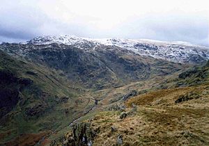
Tarn Crag (Easedale)
| Tarn Crag | |||
| Westmorland | |||
|---|---|---|---|
 Tarn Crag from Gibson Knott | |||
| Range: | Lake District Central Fells | ||
| Summit: | 1,804 feet NY301093 54°28’23"N, 3°4’34"W | ||
Tarn Crag is a fell in the Central Fells of the Lake District, within Westmorland. (Another Tarn Crag is to be found in the 'Far Eastern Fells', also in Westmorland.)
Strictly the name 'Tarn Crag' applies only to the rock face looking down upon Easedale Tarn, but Alfred Wainwright applied it to the entire ridge lying between the Easedale and Far Easedale valleys in his Pictorial Guide to the Lakeland Fells
Landscape
The spine of the Central Fells runs north from High Raise, forming the watershed between Thirlmere and Borrowdale. A number of lesser ridges radiate out eastwards from High Raise, centred upon the subsidiary top of Sergeant Man. One of these runs between the valleys of Far Easedale and Easedale, terminating at their confluence above Grasmere village.
The ridge is narrow to the east of the summit, rising over a series of knolls between the gradually diverging valleys. Westward it broadens considerably, swinging southward around the head of Codale Tarn before becoming indistinct in the general rising ground towards Sergeant Man and the High Raise massif. Codale Tarn is a shallow pool, its original outlet blocked by a moraine so that it now overflows by a rock lip.[1]
The southern flank of the fell comprises Tarn and Greathead Crags, the backdrop to the popular picnic spot of Easedale Tarn. Much larger than Codale, this tarn is around 70 feet deep and contains perch, eel and trout.[1] Across the tarn are the crags of Blea Rigg. On the northern side of the ridge Deer Bields Crag broods over Far Easedale, with Calf Crag beyond.
Geology
The summit area is composed of the dacitic welded lapilli-tuff and volcaniclastic sandstone of the Lincomb Tarns Formation. The southern crags reveal andesite sills and the pebbly sandstone and breccia of the Pavey Ark Member.[2]
Summit
The highest point is a peaked outcrop, topped by a small cairn. The views eastward are extensive and Easedale Tarn can be brought into view from a subsidiary top to the south.[3]
Ascents
Tarn Crag is generally climbed from Grasmere by its eastern ridge, where a path winds among the rocks. This can be reached from Easedale Tarn, the top of the Sour Milk Gill cascades, or from Stythwaite Steps in Far Easedale. Ascents from the base of Deer Bield Crag or by way of Codale Tarn are also possible, although pathless.[4]
References
- ↑ 1.0 1.1 Blair, Don: Exploring Lakeland Tarns: Lakeland Manor Press (2003): ISBN 0-9543904-1-5
- ↑ British Geological Survey: 1:50,000 series maps, England & Wales Sheet 29: BGS (1999)
- ↑ Wainwright, Alfred: A Pictorial Guide to the Lakeland Fells, Book Three — The Central Fells (1958)
- ↑ Mark Richards: The Central Fells: Collins (2003): ISBN 0-00-711365-X