Thorne
| Thorne | |
| Yorkshire West Riding | |
|---|---|
 St Nicholas's Church, Thorne | |
| Location | |
| Grid reference: | SE6891212950 |
| Location: | 53°36’30"N, -0°57’30"W |
| Data | |
| Population: | 16,592 (2001) |
| Post town: | Doncaster |
| Postcode: | DN8 |
| Dialling code: | 01405 |
| Local Government | |
| Council: | Doncaster |
| Parliamentary constituency: |
Don Valley |
Thorne is a modest market town in the West Riding of Yorkshire, with a population of 16,592 recorded in 2001. It lies close to Doncaster, on the very eastern edge of the West Riding, close up against Yorkshire's boundary with Lincolnshire, the Isle of Axholme in the latter county lying against it.
Thorne lies east of the River Don, on the Stainforth and Keadby Canal, and is at around 16 feet above sea level, on the Yorkshire side of the border with Lincolnshire.
History
The land which is now Thorne was once inhabited by Neolithic, Bronze Age and Iron Age people. It is believed that the village itself was settled in the Anglo-Saxon period. Thorne is listed in the Domesday Book.
The main industries in and around the town have traditionally been coal mining and farming.
Culture and community
Thorne Memorial Park is the location for the Thorne Memorial Park Miniature Railway and the annual Thorne Festival. During the summer months, free brass band concerts are held at the park's bandstand.
Bunting's Wood is a community woodland created from agricultural land by Thorne-Moorends Town Council, and The Peatlands Way, a circuitous walk around the wildlife areas of Thorne and Hatfield Moors, passes to the north of the town.[1]
Thorne's Farmers' Market is a monthly event. The area now has its own Community Radio station, TMCR 95.3.
Parish church
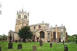
The parish church is St Nicholas. It was built in the 12th century but added to and rebuilt in later centuries so that it contains elements from the 12th to 15th centuries with some later additions and repairs. It is Grade I listed.[2]
Sights of the town
Notable buildings in the town include the parish church and Peel Hill Castle. Peel Hill Castle is the earthwork remains of a Norman motte built by the de Warenne family. Although no structure remains, the foundations indicate that it had a circular keep. It might have been used as a hunting lodge, connected with Hatfield Chase, and prisoners were kept in its tower in the 16th century. The castle was demolished in the 17th century.[1] The monument is in the care of Thorne-Moorends Town Council.[3]
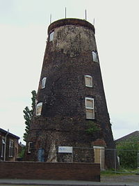
There are Dutch-style bridges over local canals, such as the Wykewell bridge. There are two large water towers. Nearby are the extensive Thorne Moors.
Transport links
The town is served by two railway stations: Thorne North, and Thorne South.
Junction 6 of the M18 motorway and Junction 1 of the M180 are close by. The A614 runs through the town, crossing the canal. Many residents commute to Doncaster.
Sport
- Rugby league: Moorends-Thorne Marauders RLFC
- Rugby union: Thornensians RUFC
- Football:
- Moorends Hornets
- Stingers Junior Football Club.
Speedway racing, earlier known as Dirt track racing, was staged at a track on the southern edge of the town in 1930. Billed as "The Wembley of the North" the track followed the edge of the football pitch on the inside of the track. (Rather than two sweeping bends, the track is shown on contemporary Ordnance Survey maps as having four corners and four straights.)

Outside links
| ("Wikimedia Commons" has material about Thorne) |
- Thorne and Moorends Town Council
- Friends of Buntings Wood
- Thorne Memorial Park Miniature Railway
- Thornensians Rugby Union Football Club
- 750 (Thorne) Squadron Air Training Corps; Thorne Air Cadet Squadron
References
- ↑ 1.0 1.1 "Thorne-Moorends Town Council: The Peatlands Way 50 Challenge Walk; Thorne-moorends.gov.uk. Retrieved 28 April 2012
- ↑ Images of England — details from listed building database (334690) Church of St Nicholas, Thorne
- ↑ "Peel Hill Thorne". Castle UK. http://www.castleuk.net/castle_lists_north/111/thornecastle.htm. Retrieved 2012-04-07.
