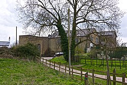
Tringford
| Tringford | |
| Hertfordshire | |
|---|---|
 Tringford Pumping Station | |
| Location | |
| Grid reference: | SP915137 |
| Location: | 51°48’54"N, -0°40’22"W |
| Data | |
| Post town: | Tring |
| Postcode: | HP23 |
| Local Government | |
| Council: | Dacorum |
| Parliamentary constituency: |
South West Hertfordshire |
Tringford is a hamlet in western Hertfordshire, to the north of Tring. It consists of a scatter of houses and industrial buildings along the lanes and the B489, to the west of three adjoining reservoirs which supply the Grand Union Canal at its highest point - Startop's End Reservoir, Tringford Reservoir and Marsworth Reservoir.
The Grand Union Canal itself is just to the north, and two of its arms branch off here: the Aylesbury Arm to the north of Tringford at Startop's End and the Wendover Arm to the east of Tringford.
Little Tring, which is much the same size as Tringford, lies to the south. The Buckinghamshire boundary is close by to the northeast and to the southwest: this is the narrowest part of the Tring Salient.