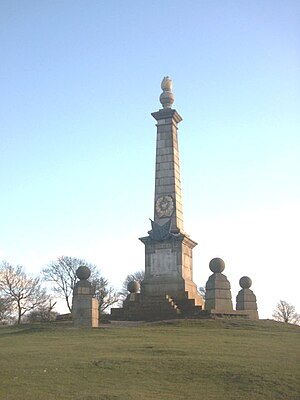
Coombe Hill, Buckinghamshire
| Coombe Hill | |||
 The monument on Coombe Hill | |||
|---|---|---|---|
| Range: | Chilterns | ||
| Summit: | 852 feet SP849067 51°45’9"N, -0°46’17"W | ||
Coombe Hill is a hill in the Chilterns, in Buckinghamshire, standing next to the hamlet of Dunsmore and nearby Wendover. It overlooks the Aylesbury Vale, and rises to a summit at 852 feet above sea level. (Another 'Coombe Hill' is a subsidiary rise on the flank of Haddington Hill, just two miles to the northeast.)
The majority of the hill - an area of 106 acre - once formed part of the Chequers Estate but was presented to the National Trust by the Government when they were given the Estate in the 1920s.
The Coombe Hill Monument
Coombe Hill Monument is one of the first and largest examples of a war memorial erected to honour the names of individual men who fell whilst fighting for their country, in this case those who fell in the Boer War. The monument is an iconic Buckinghamshire landmark and a Grade II Listed monument. At 853 feet above sea level, it sits on one of the highest and most striking spurs of the Chilterns, commanding a wide view of the Vale of Aylesbury. On a clear day the monument can be seen from the Berkshire Downs and Salisbury Plain to the south-west and the Cotswolds to the west. The view overlooks Chequers, the country residence of the Prime Minister.
The monument was erected in 1904, by public subscription, in memory of 148 men from Buckinghamshire who died during the Second Boer War. Coombe Hill Monument was almost totally destroyed by lightning in 1938 and was rebuilt in the same year. The original bronze plaque and decorations were stolen in 1972 and replaced with a stone plaque and iron flag. The new stone plaque was also inscribed with the additional names of nine men believed to have been missing on the original. The monument was again badly damaged by a lightning strike in the early 1990s and spent several months in repair. It is now equipped with conductors to prevent the mishap happening again. The monument and a few square yards of surrounding land are owned by Buckinghamshire County Council.
On 21 October 2010 the monument was rededicated after substantial restoration work. The work was done by the Council with funds raised by the Coombe Hill Monument Appeal Committee. A new plaque corrects spelling errors in the original and adds 2 names that were previously omitted [1]
Triangulation point and plaque
In front of the monument is a rectangular concrete pillar that is the trig point and it is topped with a metal plaque donated in 1988 that points to true north and to the following distant features: The Cotswolds (53 miles), Brill Hill (13 miles), Waddesdon Manor (10 miles), Calvert Chimneys (15 miles), Aylesbury Church (5 miles), Mursley Water Tower (15 miles), Wingrave Church (8 miles), Leighton Buzzard (12 miles), Mentmore (9 miles), Edlesborough Church (11 miles) and Ivinghoe Beacon (9 miles).
Flora and fauna
Coombe Hill has 3 different types of land including acid heathland, chalk grassland and deciduous woodland. It is home to much interesting wildlife — including Red Kites, Yellowhammers and Firecrests. It also holds the habitat to many rare plants such as heather, orchids and the Chiltern gentian. Due to its rarity the acid moorland is a Site of Special Scientific Interest (SSSI).
Coombe Hill Run
A 6km running race organised by the Vale of Aylesbury Athletic Club which includes 620 feet of climbing up to the monument on Coombe Hill, the Coombe Hill Run is a rare example of a fell race in southern Britain. First held in 1973, and now held on the first Sunday in June, it attracts more than 200 runners.
Outside links
References
- ↑ Dunhill, Lawrence (24 Aug 10), "Spelling errors on Coombe Hill war memorial to be corrected", Bucks Free Press, http://www.bucksfreepress.co.uk/news/8348318.Spelling_errors_on_war_memorial_to_be_corrected/, retrieved 24 Dec 10