Finchley
| Finchley | |
| Middlesex | |
|---|---|
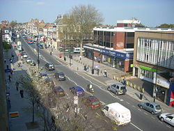 Ballards Lane, Church End, Finchley | |
| Location | |
| Grid reference: | TQ255905 |
| Location: | 51°35’56"N, 0°11’13"W |
| Data | |
| Post town: | London |
| Postcode: | N2, N3, N12 |
| Dialling code: | 020 |
| Local Government | |
| Council: | Barnet |
| Parliamentary constituency: |
Finchley and Golders Green |
Finchley is a town in Middlesex, all within the northern reaches of the metropolitan conurbation. Finchley is predominantly a suburban, residential town with three distinctive town centres.
The town is on high ground, about 7 miles north of the heart of London.
The name of the town is from Old English, and probably means "Finch Clearing"; the name though is first recorded in the early 13th century.[1]
History
Finchley is not recorded in the Domesday book, but by the 11th century its lands were already included in those of the Bishop of London.[2]
In the early mediæval period the area was sparsely populated woodland. During the 12th and 13th century proper farming began, and by the 15th and 16th century the woods on the eastern side of the parish were cleared to form Finchley Common.[3]
The mediæval Great North Road, which ran through the common, was notorious for highwaymen until the early 19th century.[1]
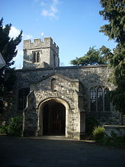
In the 1270s the parish church of St Mary is first recorded. The settlement at Church End grow up around it.[4] Near the northern gate to the Bishop of London's park the hamlet of East End, later East Finchley had begun to develop by 1365.[5][6]
The Edgware, Highgate and London Railway (later the Great Northern Railway) reached Finchley in 1867.[7] The route ran from Finsbury Park in London via Finchley to Edgware. The High Barnet branch opened from Finchley in 1872. All this encouraged the suburban growth of the town.
In 1905 tram services were established in Finchley, and extended shortly after to Barnet.[8] They were eventually replaced by trolley buses.[9]
In 1933, the Underground New Works Programme, 1935-1940 was announced, to electrify the lines through Finchley, and connect the Northern Line from Archway to East Finchley, by way of a new tunnel.
Much of the work was carried out, with East Finchley station being completely rebuilt, until stopped by the Second World War. All passenger services from Finchley to Edgware ended in September 1939. Nevertheless, Underground trains began running from central London to High Barnet in 1940, and to Mill Hill East, to reach the large army barracks, in 1941.
After the war, the introduction of London's Metropolitan Green Belt undermined pre-war plans, and the upgrading between Mill Hill East and Edgware (the 'Northern Heights' project) was abandoned, although the line continued to be used by steam trains for goods traffic through Finchley, until it closed completely in 1964.
Geography
Finchley is on a plateau 300 feet above sea level, about 4 miles south of Barnet. To the west is the Dollis valley formed by Dollis Brook which is the natural western boundary of Finchley.[1] Mutton Brook forms the southern boundary, joining the Dollis Brook to become the River Brent.
Geologically, Finchley is formed of three layers. Most of Finchley is on Boulder clay or glacial moraine, skirted by a layer of gravel, then the underlying layer of London clay. This roughly triangular gravel line was the most fertile area; hamlets grew at the three corners, which evolved into Finchley's early population centres[5] corresponding to the three town centres in the area:
- Church End, often known as "Finchley Central" (particularly since the tube station was renamed), the area north and west of the North Circular Road, centred around Ballards Lane and Finchley Central tube station;
- East Finchley, roughly the area between Highgate and the North Circular Road; and
- North Finchley, the area surrounding Tally-Ho Corner, stretching west to and the Northern Line.
The residential areas West Finchley and Woodside Park are centred on their respective tube stations to the west of the area.
The area of the Middlesex known as Finchley Road, around Finchley Road tube station, is not part of Finchley, but instead refers to a commercial district in Swiss Cottage, much further south along the Edgware Road. The area is named after a section of the A41 road, which eventually runs north to Finchley.
Sights of the town
St Mary's at Finchley is the parish church, with parts dating from the 13th century. Avenue House, built in 1859, is a large Victorian house (Grade II listed) with ten acres of parkland situated on East End Road. It was formerly the home of ink magnate and local MP Henry Charles Stephens and houses a small museum relating to the Stephens family, the Stephens company and the history of writing materials.
College Farm is the last farm in Finchley; it was a model dairy farm, then a visitor attraction. The Phoenix Cinema in East Finchley with its 1930s art deco facade is one of the oldest purpose-built cinemas in the UK.
The Sternberg Centre for Judaism located in the old Manor House (formerly the convent and school of St Mary Auxiliatrice) at 80 East End Road in Finchley is a Jewish cultural centre. It was founded to facilitate a number of important Reform and Liberal Jewish institutions, attached to the Movement for Reform Judaism.
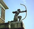
The Archer, located on East Finchley tube station, is a 10-foot statue by Eric Aumonier of a kneeling archer depicted as if having just released an arrow. The statue La Délivrance depicts a naked women holding a sword; it stands at the approach to Finchley from the south, in Regent's Park Road, just north of Henly's Corner.
Transport
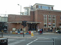
Finchley is served by four London Underground stations, all on the High Barnet branch of the Northern Line:
- East Finchley tube station in zone three, serves East Finchley and is 21 minutes from Charing Cross.
- Finchley Central tube station in zone four, serves Finchley, Church End and is 25 minutes from Charing Cross.
- West Finchley tube station in zone four, serves North Finchley and is 27 minutes from Charing Cross.
- Woodside Park tube station in zone four, serves North Finchley and is 29 minutes from Charing Cross.
Two of London's major roads, the east-west A406 North Circular Road and the north-south A1 meet and briefly merge at Henly's Corner at the southern edge of Finchley.
Sports
- Cricket: Finchley Cricket Club, founded 1832
- Football: Wingate & Finchley. The team was founded as a specifically Jewish football club in 1946.
- Golf: Finchley Golf Club on Frith Lane
- Rugby: Finchley RFC
Cultural references
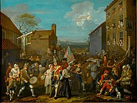
William Hogarth painted his satirical 'March of the Guards to Finchley' in 1750. It is a depiction of a fictional mustering of troops on the Tottenham Court Road to march north to Finchley to defend the capital from the second Jacobite rebellion of 1745.
A number of fictional characters have been associated with the area, including:
- In Charles Dickens' The Old Curiosity Shop Mr Garland, one of the principal characters, lives in "Abel Cottage, Finchley".
- Bluebottle, a character in the 1950s BBC radio series The Goon Show, hails from East Finchley, where Peter Sellers who played Bluebottle used to live at one time.
- In various episodes of the Channel 4 comedy Peep Show Finchley is used as an on-site shooting location.
- In the 2005 film The Chronicles of Narnia: The Lion, the Witch and the Wardrobe, Susan Pevensie says that she and her siblings, Peter, Edmund, and Lucy, are from Finchley, despite no mention of Finchley being made in C S Lewis's books - it is only mentioned that they are from London.
- The Monty Python's Flying Circus comedy sketch, The Funniest Joke in the World, is set in Finchley.
Pictures
-
Dollis Brook Viaduct
-
Art Deco 'Archer' Statue at East Finchley Tube Station by Eric Aumonier
-
The Phoenix Cinema
-
Route of Edgware, Highgate and London Railway highlighted on a 1900 map
Outside links
- The Finchley Society
- The Finchley Arrow
- Finchlinks - For the bits of Finchley outside the North Circular
References
- ↑ 1.0 1.1 1.2 A History of the County of Middlesex: Volume 6 (Victoria County History) pages=38–55
- ↑ A short history of Finchley – Heathfield, John (The Finchley Society)
- ↑ Nurse, Richard (2007-11-20). "Finchley and Friern Barnet". LB Barnet. http://www.barnet.gov.uk/index/leisure-culture/libraries/archives/archives-histories/archives-finchleyhistories.htm. Retrieved 2009-09-23.
- ↑ Nurse, Richard (13/02/2008). "Finchley N3 Hendon Lane". LB Barnet. http://www.barnet.gov.uk/index/leisure-culture/libraries/archives/archives-histories/archives-finchleyhistories/archives-finchley-hendonlane.htm. Retrieved 2009-09-23.
- ↑ 5.0 5.1 Weinreb, Ben; Christopher Hibbert. The London Encyclopedia. Julia Keay, John Keay (3rd ed.). Macmillan. pp. 290–291. ISBN 978-1-4050-4924-5.
- ↑ Nurse, Richard (13/02/2008). "Finchley N2 East End Road". LB Barnet. http://www.barnet.gov.uk/index/leisure-culture/libraries/archives/archives-histories/archives-finchleyhistories/archives-finchley-eastendroad.htm. Retrieved 2009-09-23.
- ↑ Clive's Underground Line Guides, Northern Line, Dates
- ↑ London Transport Museum Tram in Finchley, dated 1905 to 1915
- ↑ London Transport Museum Trolley bus at North Finchley

