Meall na h-Eilde
| Meall na h-Eilde | |
| Inverness-shire | |
|---|---|
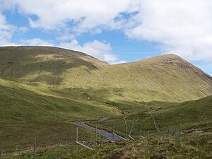
 Meall na h-Eilde from the head of Gleann Cia-aig | |
| Summit: | 2,749 feet NN185946 57°0’23"N, 4°59’24"W |
Meall na h-Eilde is a mountain in Inverness-shire, in the high ground between the Great Glen and Glen Garry, 14 miles north of Fort William.
Overview
Meall na h-Eilde reaches a height of 2,749 feet. It has only been included on the list of Corbetts since 1981 when resurveying by the Ordnance Survey raised its height to 838 metres and above that of the nearby Meall Coire nan Saobhaidh which before that was regarded as the Corbett summit.
The name Meall na h-Eilde means "Hill Of The Hinds".
History
The hills outlying top Meall an Tagraidh which lies a mile southeast of the main summit has some historical interest. This summit was used as a hideout for several days and nights by the fugitive Charles Edward Stuart, the Young Pretender, during his flight following the Battle of Culloden in April 1746. The fugitive prince was supplied with whisky, cheese and bread by Cameron of Clunes during his stay on the hill.[1]
The name "Hill of the Hinds" is so called because the hills steep walled eastern corrie, Coire an Tagraidh, gave good shelter from the western gales and was a good place for hinds to protect and rear their young.[2]
Geography
Meall na h-Eilde has only one distinctive ridge which goes northerly towards Glen Garry, it runs for a mile, passing several small lochans before reaching a shoulder on the ridge known as Gearr Leacann (Short Steep Ridge) (1,696 feet). From here it descends steeply to the Glen Garry forestry plantation where it broadens out into the valley floor. A broader ridge goes southwest for a mile to a spot height at 2,234 feet (681 m) where it narrows and steepens considerably to reach the head of Gleann Tarsuinn. Meall na h-Eilde is connected to its two outlying tops Meall Coire nan Saobhaidh and Meall an Tagraidh by high cols.
Meall Coire nan Saobhaidh lies just over half a mile to the northwest across the Bealach Choire a’ Ghuirein (The Pass of the Corrie of the Pimple) which has a height 2,369 feet.[3]
The hill is connected to Meall an Tagraidh, an attractive conical hill, by the Bealach an Easain (The Pass of the Little Waterfall)[4] which has an approximate height of 2,070 feet. A ruined iron fence runs along the skyline ridge between the main summit and these two outliers which formerly marked the old parish boundary and this can be an aid to navigation in poor weather.
The hill stands on the main watershed; its southern flowing streams reaching the Great Glen and going by Loch Lochy and Loch Linnhe to reach the west coast while drainage from its northern slope goes by way of the River Garry to reach the Great Glen at Loch Oich and then goes eastward via Loch Ness to reach the sea at Inverness.[5]
Ascents
Meall na h-Eilde is often climbed in conjunction with another Corbett, Geal Charn which lies 2½ miles to the west. Approaches to the hill are possible from the north (Glen Garry) and the south (eastern end of Loch Arkaig) although the southern approach is shorter and more poplar.
The southern route starts at the car park at the Eas Chia-aig waterfall at grid reference NN176888 and follows a track north through the trees of Gleann Cia-aig to reach open moorland after 2½ miles where the hill comes fully into view. A footbridge is crossed and it is a steep climb to the Bealach an Easain from where the summit is easily reached. The northern approach starts at Greenfield in Glen Garry (NH200005) and takes a path south west through the forest for three km to reach the Allt Coire nan Saobhaidh stream from where the northern ridge can be gained which leads to the summit cairn which stands on the northern side of the old fence.
The hill's considerable prominence of 1,486 feet gives a good uninterrupted view of the surroundings.[6]
References
- ↑ "Hamish‘s Mountain Walk / Climbing The Corbetts", Hamish Brown, ISBN 1-898573-08-5, Page 248 Gives details of Charles Edward Stuart.
- ↑ "The Call Of The Corbetts", Irvine Butterfield, ISBN 0-7153-2754-2, Page 74 Gives details of name meaning.
- ↑ www.clan-cameron. Gives translation of Bealach Choire a’ Ghuirein.
- ↑ Online Gaelic-English Dictionary. Gives other Gaelic translations.
- ↑ www.sub3000. Gives details of geography and some history.
- ↑ "The Corbetts And Other Scottish Hills", Scott Johnstone et al (editors), ISBN 0-907521-29-0, Page 143 Gives details of routes of ascent.