Great Gaddesden
| Great Gaddesden | |
| Hertfordshire | |
|---|---|
 St John The Baptist | |
| Location | |
| Grid reference: | TL023110 |
| Location: | 51°47’19"N, -0°31’3"W |
| Data | |
| Postcode: | HP1
LR |
| Local Government | |
| Council: | Dacorum |
Great Gaddesden is a village spread across the borders of Hertfordshire and Buckinghamshire; the county border here has a tortured course amongst the hills and the village is broken into sections. It has no obvious centre, but the parish church stands in a section which is in Hertfordshire albeit close by the border.
The village lies amongst the Chiltern Hills, close to and in part along the A4146, north of Hemel Hempstead. Nearby are Flamstead, Hemel Hempstead, Nettleden and Little Gaddesden and also to Studham in Bedfordshire.
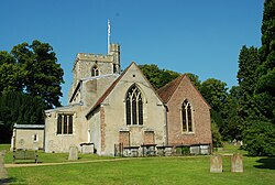
The parish church is St John the Baptist. The church shows features of every period since the 12th century. Part of the chancel has Roman bricks but in construction it dates back to the early 12th century. The old church was extended by the south aisle in the 13th century and the north aisle in the 14th century, the west tower was built in the 15th century and the north chapel in the 18th.
The medieval convent of St Margaret's stood northwest of the village.
Gaddesden Place, positioned east of the small village was built from 1768 to 1773 for the Halsey family. It is surrounded by a huge park. In 1905 a fire destroyed the interior of the main house.
The River Gade has its name from Gaddesden or Gaddesden from the Gade. Its clear water is used for watercress beds along the river and at Water End south of Great Gaddesden is an old corn mill provided by the stream. The bridge over the river at Water End has a medieval appearance but was built in the 19 century.
Outside links
| ("Wikimedia Commons" has material about Great Gaddesden) |
