Blencarn
| Blencarn | |
| Cumberland | |
|---|---|
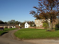
 The village green, Blencarn | |
| Location | |
| Grid reference: | NY637312 |
| Location: | 54°40’30"N, 2°33’43"W |
| Data | |
| Post town: | Penrith |
| Postcode: | CA10 |
| Dialling code: | 01768 |
| Local Government | |
| Council: | Westmorland & Furness |
| Parliamentary constituency: |
Penrith and The Border |
Blencarn is a village in Cumberland, on the Blencarn Beck in the east of the county and just half a mile north of the Crowdundle Beck which forms the border with Westmorland.
Blencarn is stands beneath the Pennines, which rise to the north. Just a few hundred yards east of the village is the course of a Roman road, which runs north up to Kirkland. The remains of mediæval strip lynchets are found on the slopes here close to this road to the north-east of the village: once assumed to be Roman earthworks, they are known anachronistically as the Hanging Walls of Mark Anthony.[1] A long-distance trail, A Pennine Journey runs along the slopes here too, past the Hanging Walls and on to Cross Fell (2,930 feet).
The Blencarn Beck runs north-west to Skirwith to join the Skirwith beck, whose waters flow to the River Eden to the west.
There is fly fishing centre here, at the 15-acre Blencarn Lake.
Outside links
| ("Wikimedia Commons" has material about Blencarn) |
References
- ↑ National Heritage List /1007135: The Hanging Walls of Mark Anthony
