Cushendun
| Cushendun Scots: Cushenduin | |
| County Antrim | |
|---|---|

| |
| Location | |
| Grid reference: | D2432 |
| Location: | 55°7’31"N, 6°2’34"W |
| Data | |
| Population: | 138 (2001) |
| Post town: | Ballymena |
| Postcode: | BT44 |
| Dialling code: | 028 |
| Local Government | |
| Council: | Causeway Coast & Glens |
| Parliamentary constituency: |
North Antrim |
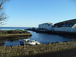
Cushendun is a small coastal village in County Antrim. It sits off the A2 coast road between Cushendall and Ballycastle. It has a sheltered harbour and lies at the mouth of the River Dun and Glendun, one of the nine Glens of Antrim. In the 2001 it had a population of 138 people.
The Mull of Kintyre in Argyllshire is only about 15 miles away across the North Channel and can be seen easily on clear days.
The nearby hamlet of Knocknacarry, which is closely related to Cushendun, is located approximately half a mile to the west.
History

Cushendun village, was built for Ronald McNeill, the Conservative MP and author later Lord Cushendun, in the style of a Cornish village and it was designed by the architect Clough Williams-Ellis. He is buried in the Church of Ireland graveyard near his nationalist cousin Ada or Ide McNeill, Roger Casement's friend and admirer who died in 1959.
Since 1954 most of the village and the parkland around Glenmona to the north has been owned by the National Trust. Cushendun's picturesque coastal setting in the heart of the “Antrim Coast and Glens Area of Outstanding Natural Beauty”, together with its unique architectural inheritance, resulted in designation as a Conservation area in 1980.
The poet John Masefield and his wife, Constance, younger daughter of Nicolas Crommelin of nearby Rockport, spent many holidays in the town.
Outside links
| ("Wikimedia Commons" has material about Cushendun) |
