Littleborough, Lancashire
| Littleborough | |
| Lancashire | |
|---|---|
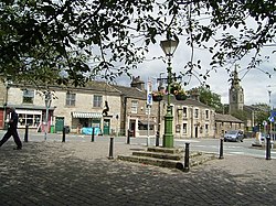
 Church Street, Littleborough | |
| Location | |
| Grid reference: | SD9316 |
| Location: | 53°38’38"N, 2°5’53"W |
| Data | |
| Population: | 13,807 (2001) |
| Post town: | Littleborough |
| Postcode: | OL15 |
| Dialling code: | 01706 |
| Local Government | |
| Council: | Rochdale |
| Parliamentary constituency: |
Rochdale |
Littleborough is a mill town in southern Lancashire, standing in the upper Roch Valley by the foothills of the Pennines. The rural uplands of Blackstone Edge are to the east.
The town is found 3 miles northeast of Rochdale and 12½ miles north of Manchester, within the Salford Hundred.
Littleborough is a town created by the Industrial Revolution and hewn from local Pennine stone. While once a busy weaving town, during the mid-20th century cheap, foreign goods forced a gradual deindustrialisation of Littleborough, but its commercial diversity allowed it to repel the ensuing economic depression experienced elsewhere in Lancashire. Littleborough endures as a commuter town with a distinct community, and remains the pretty, stone town which the mill owners raised on these hills. Littleborough's stone-built town centre is designated as a Conservation Area for its special architectural qualities.
Littleborough's Civic Trust works to preserve and enhance the town's historic character. Other societies exist to utilise the surrounding countryside for recreational activities and all the doings of our big society.
Name of the town
Littleborough became a noteworthy town only in the Industrial Age. Its name is from Old English and may be from Lytelburg ("little fort") or Lytelbroc ("little brook").
History
Around Littleborough have been found archaeological remains bearing evidence of many ages; Neolithic, Iron Age, Roman and Anglo-Saxon. Stone Age flint tools and arrowheads have been found, and an early Iron Age bracelet made of a shale from Kimmeridge in Dorset, which was found in 1929 on Flint Hill, east of Blackstone Edge, and which now sits in Rochdale Museum. A torque (or necklet) with ornamentation of a late-Celtic design was found in the Mawrode area of Littleborough in 1832.
Littleborough is supposed to have been the site of a small station along the Roman road from Mamucium (Manchester) to Eboracum (York) whose route skirts the town. Roman coins and pottery have been found, and the right arm of a silver statue of Victory.[1]
During the Middle Ages, Littleborough was a hamlet in the manor of Hundersfield and Parish of Rochdale.[2][3] It stood at the junction of two ancient routes over the Pennines, one of which may have been a Roman road, which joined to cross the River Roch.
By 1472, Littleborough consisted of a chapel, a cluster of cottages, and an inn, and its inhabitants were broadly farmers who were spurred to weave wool by merchants who passed between the markets at Rochdale and Halifax. When cotton was introduced as a base to make textiles, Littleborough experienced an influx of families, mostly from the neighbouring West Riding of Yorkshire.[3] Affluent homes and estates were established on Littleborough's fringes.
In the late-18th century, the Summit Gap between Littleborough and Walsden was approved as the best route through the Pennines for the Rochdale Canal and then for the Manchester to Leeds railway. Hollingworth Lake was built at Littleborough's south side as a feeder reservoir to regulate the waters of the canal. This infrastructure encouraged industrialists to modify Littleborough's traditional handloom cloth workshops with a mechanised form of textile production. Attracted to the area's natural resources and modern infrastructure, coal mining, engineering ventures and increasingly large textile mills contributed to Littleborough's population growth and urbanisation, sealing its status as a mill town.
In 1848 the population was chiefly employed in three flannel-mills, four cotton-factories, in bleachworks, six coal-pits, a stone-quarry, and in brick-making.[1]
Deindustrialisation struck in the twentieth century as the mills could no longer compete, and Littleborough readjusted herself to the new age.
Outside links
| ("Wikimedia Commons" has material about Littleborough, Lancashire) |
- Littleborough Civic Trust
- www.link4life.org A history of Littleborough
- Littleboroughlocal.co.uk - News, events, directory and discussion forum
References
- ↑ 1.0 1.1 Lewis 1848, pp. 101–104.
- ↑ Hignett 1991, p. 2.
- ↑ 3.0 3.1 "Rochdale Towns". spinningtheweb.org.uk. http://www.spinningtheweb.org.uk/m_display.php?irn=240&sub=nwcotton&theme=places&crumb=Rochdale. Retrieved 20 April 2008.
Books
- Brownbill, John; Farrer, William (1911). A History of the County of Lancaster. 5. Victoria County History. ISBN 978-0-7129-1055-2.
- Clark, David M. (1973). Greater Manchester Votes: A Guide to the New Metropolitan Authorities. Redrose.
- Hignett, Tim (1991). Milnrow & Newhey: A Lancashire Legacy. Littleborough: George Kelsall Publishing. ISBN 0-946571-19-8.
- Lewis, Samuel (1848). A Topographical Dictionary of England. Institute of Historical Research. ISBN 978-0-8063-1508-9.
- Rochdale Metropolitan Borough Council (N.D.). Metropolitan Rochdale Official Guide. London: Ed. J. Burrow & Co. Limited.
- Rochdale Metropolitan Borough Council (1985). Official Guide to Rochdale Metropolitan Borough. Gloucester: The British Publishing Company. ISBN 978-0-7140-2276-5.
